I think in our time Broad Street and Dale End was considered to be one. At least that's how I always saw it. Anyway the end of Dale End/Broad St. opened out which I always thought was to provide space for the open Welsh/Welch market. As you can see the Welsh market had it's own version of the Cross (not shown on this map) but right in the middle of that junction. I travelled through there every week day for years, tram and bus,...wish I had paid more attention. Actually the map post #33 also shows the run of the stream down from Temple Row and bridges over it at High St., Moor St., and Park St. I thought there was a stream somewhere but this is the first time I have seen it in this detail. It also shows the location of the Manor Mill on Upper Mill Lane...in the courtyard outside the manor gate. We have a sketch with this mill on it which I feel we can identify now with a little bit of conviction. Nicely done.
-
Welcome to this forum . We are a worldwide group with a common interest in Birmingham and its history. While here, please follow a few simple rules. We ask that you respect other members, thank those who have helped you and please keep your contributions on-topic with the thread.
We do hope you enjoy your visit. BHF Admin Team
You are using an out of date browser. It may not display this or other websites correctly.
You should upgrade or use an alternative browser.
You should upgrade or use an alternative browser.
Lost streets of birmingham
- Thread starter Astonian
- Start date
These are screenshots extracted from Judy's post #34 youtube clip (Bernard Sleigh's 1923 map) showing the junction of The New Street with High Town and another of The Market Cross area. Viv.


Celia Dillworth
Spencer Street Pupil
Anyone Born or lived in St Helen's Passage of Vittoria Street ? Names I recall Are The Praters, Gilberts, Frosts, Bishops,Georges, Small,
Mountneys, Mc Court's, I went to St Paul's School, Spencer Street, Anyone else have memories ?????
Love to hear from you .
Mountneys, Mc Court's, I went to St Paul's School, Spencer Street, Anyone else have memories ?????
Love to hear from you .
Dancing Queen 15
knowlegable brummie
I remember Godwin St where I was born and Lupin St where my mom went to school. My parents married st St Mathews Church and I was christened there 1940Thanks Phil, at least I can now see exactly where it was.
jeannette smith harrison
Brummie babby
My g grandparents & many of my Canal boatmen married at st Gabriels giving the address of his sister in barn st does a map exist where I can locate where in barn st their house was this was in 1895
pjmburns
master brummie
Maygladwin8
New Member
Found this interesting site whilst searching for information on Alfred Daniel James , my grandfather.
Though brought up in Pontypridd Glamorgan ,he was recruited to the Royal Engineers at the beginning ofWW1. His address was given as St John Street Lozells, the home of a relative.
Later in 1918 he was an absent voter from 59 Gordon Street Aston, or 59 Bristol Terrace . Not sure if the latter was a mistake or if Bristol Terrace was part of Gordon Street. Does anyone have any idea ?
Found this interesting site whilst searching for information on Alfred Daniel James , my grandfather.
Though brought up in Pontypridd Glamorgan ,he was recruited to the Royal Engineers at the beginning ofWW1. His address was given as St John Street Lozells, the home of a relative.
Later in 1918 he was an absent voter from 59 Gordon Street Aston, or 59 Bristol Terrace . Not sure if the latter was a mistake or if Bristol Terrace was part of Gordon Street. Does anyone have any idea ?
i would need to double check but i am pretty certain that there is not a st john st in lozells....however there is a john st
lyn
Phil
Gone, but not forgotten.
Does anyone have a map with Inkerman St and Coleman St on the same page please?
Hi Mizzyjo
Sorry about the delay but I've only just seen your request. To get these two roads on the same map you have to go back to the 1950's as Colman Street was one of the first streets to go in the redevelopment of Nechells. Inkerman Street is in the bottom right quadrant and Colman Street is in the upper left one.

A complete set of 1/500 maps for Birmingham 1888 are available on Midland Ancestors web site https://midland-ancestors.shop/Warwickshire/BHAMMAP
choccy7843
New Member
would anyone know of long acre or hingeston street
choccy7843
New Member
wow. my great grandparents live there 1930-1935 from what I have found so far. trying to find pictures of the street.Yes, my brother and sister in law lived in Long Acre!! They were robbed one night while they were in bed and my sister in law refused to continue to live there!!
mizzyjo
master brummie
thank you for this Phil. It's my mom's old stamping ground! Put's it all in perspective! xxxxHi Mizzyjo
Sorry about the delay but I've only just seen your request. To get these two roads on the same map you have to go back to the 1950's as Colman Street was one of the first streets to go in the redevelopment of Nechells. Inkerman Street is in the bottom right quadrant and Colman Street is in the upper left one.
View attachment 128515
Maygladwin8
New Member
would anyone know of long acre or hingeston street[/QUOTE
Yes Hingestion is still there though much changed. I found it near the English Heritage Silver Factory, not far from the Pen Factory. My g grandparents are on 1881 in the old Hingestion.Someone sent me this image.
Gill

choccy7843
New Member
Fantastic Picture, and appreciate the information, thank you x
Radiorails
master brummie
A lot of information here:
https://birminghamhistory.co.uk/forum/index.php?threads/hingeston-street.13746/page-9#post-609433
Do a search for the pubs in Hingeston Street as there is probably more there as well.
Also a search for Long Acre produces much of interest.
https://birminghamhistory.co.uk/forum/index.php?threads/hingeston-street.13746/page-9#post-609433
Do a search for the pubs in Hingeston Street as there is probably more there as well.
Also a search for Long Acre produces much of interest.
choccy7843
New Member
A great thread, lots of interesting information and loved showing my family the photos xA lot of information here:
https://birminghamhistory.co.uk/forum/index.php?threads/hingeston-street.13746/page-9#post-609433
Do a search for the pubs in Hingeston Street as there is probably more there as well.
Also a search for Long Acre produces much of interest.
Williamstreeter
master brummie
Hello Maygladwin8 and welcome, I as a lad used to fetch errands for a woman in our st , her mother used to live in Hingeston St her name was Tranter that was way back in the late 50's though . I married a young lady from Winson Green and used to go up and down Hingeston St regularly on the number 96 bus
Holytrinity
New Member
Hi, I'm brand new to the site so be gentle with me!! I'm looking back to my Mom and Dad's early years. Mom born in Water Street opposite a lock keepers cottage, have found some old pics of Water Street but not many. Any ideas of whereabouts the lock keeper might have lived?
Dad born in Gordon Street in Small Heath. His family were bombed out during the blitz and he says that Gordon Street was all demolished. I know there is a Gordon Street still in that area but Dad says that the one he lived in was just at the back of the Blues ground, does anyone have any info about this one?? Thanks
Dad born in Gordon Street in Small Heath. His family were bombed out during the blitz and he says that Gordon Street was all demolished. I know there is a Gordon Street still in that area but Dad says that the one he lived in was just at the back of the Blues ground, does anyone have any info about this one?? Thanks

On the Midland Ancestors web site Birmingham 1888 maps it lists Gordon Street in the index with house numbers.
It also lists Water Street and Farmers Bridge Locks
Birmingham maps c.1888 - Download
Midland Ancestors was given about 400 very detailed street maps of Birmingham and its surroundings that were surveyed by The Ordnance Survey around 1887-1888. Each map covers an area of about 500 yards by 350 yards, and the scale of 1:500
midland-ancestors.shop
It also lists Water Street and Farmers Bridge Locks
Last edited:
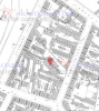
AS far as I can see , the lock keepers cottage must have been one of the two below, marked by red arrow.. These seem to be still there (at least when Streetview last visited) at https://goo.gl/maps/bWFqGgK1Jc12


oldMohawk
gone but not forgotten
Complementary to the map in post#54, two aerial views dated 1939Dad born in Gordon Street in Small Heath. His family were bombed out during the blitz and he says that Gordon Street was all demolished. I know there is a Gordon Street still in that area but Dad says that the one he lived in was just at the back of the Blues ground, does anyone have any info about this one?? Thanks
View 1 and Gordon Street runs diagonally across the pic from Garrison Lane on the left to Garrison Street on the right.
View 2 shows the area with Gordon Street between the red lines.

source https://britainfromabove.org.uk
A 1945 aerial view on Google Earth suggests that the east side of Gordon Street was heavily bombed. Compare the lighter colour to the dark colour of nearby intact housing.

Holytrinity
New Member
Thank you all for this info, its amazing that you have come up with thus so quickly! I'm planning to take Mom to Water St soon for a look round and I can show Dad these pics and see if he can tell me which house he lived in. Really grateful!
