-
Welcome to this forum . We are a worldwide group with a common interest in Birmingham and its history. While here, please follow a few simple rules. We ask that you respect other members, thank those who have helped you and please keep your contributions on-topic with the thread.
We do hope you enjoy your visit. BHF Admin Team
You are using an out of date browser. It may not display this or other websites correctly.
You should upgrade or use an alternative browser.
You should upgrade or use an alternative browser.
Passages, Alleyways Gulletts and Snickets of Old Brum
- Thread starter Dennis Williams
- Start date
Dennis
The Paternoster Row name actually seems to appear around 1876. It is not listed previously in directories, even in the lists of small terraces etc at the beginning of the directories. The only listed occupant then is Cund Bros.lithographers & printers, which will be the Moor St printing works which is shown in hte 1890 map as running down the south side of the Row. Just a thought. The London Paternoster Row was apparently known as a centre for the publishing, stationers and bookselling trades (https://www.british-history.ac.uk/report.aspx?compid=45042 ). Could the presence of a large printing works be the reason for naming the birmingham one the same?
Mike
To add to my last comment on Paternoster Row and publishing, stationary connections. The Row came out between 31 and 35 Moor St. the following were nearby;
Court 6 (between 20 & 21) Osborn Wm. lithographic printer
( No number but around 32 ) White & Pike, printers & account hook makers
White & Pike's Railway Guide, White & Pike, publisher
35 & 36 Evans & Adlard, paper makers
39 Shipway Geo.& John Henry, printers
Also.For some reason i put Orme St instead of Orwell passage in post 156. getting a bit befuddled. Have corrected it
Mike
Dennis Williams
Gone but not forgotten
Yes Dek, sorry I should have known it had been trawled before, but there is still nothing to beat Mike's theory of a link to the Printing Trade methinks to explain the name? Some clever clogs will do it though, I have no doubt - there are some astonishing researchers on this Site.
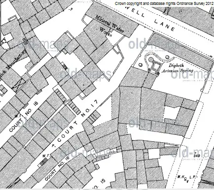
Interesting Mike. Great map. The Artesian well marked would fit in with the original map I got from another site showing the fault line that fed the wells around Digbeth and presumably the nearby de Bermingham Moat and the River Rea. I know that the area of High Street from the Bull Ring to the Police Station (Allison St) was first called Cock or Well Street (see map). And of course in Well Street was Assinder’s famous Tripe House, from which of course Aston Villa developed their perennial football style. Not many people know that…
Sorry if I've deviated a little from Thread topic.
Last edited:
dek carr
gone but not forgotten
Assinder’s famous Tripe House, from which of course Aston Villa developed their perennial football style. Not many people know that…
Dennis i am so impressed with your vast knowledge i am learning so much off you whoever i must question the above statement to my knowledge for the last 120 years all the tripe has been played at St Andrews.Dek
Dennis i am so impressed with your vast knowledge i am learning so much off you whoever i must question the above statement to my knowledge for the last 120 years all the tripe has been played at St Andrews.Dek
Dennis Williams
Gone but not forgotten
And just to add a little more to the Castle Street file, already mentioned by Dek, Moss and Aidan in posts 49, 50, and 51 plus Phil's picture in post 61 shows it when it may have been a continuation of Shut Lane. There is a horse and cart in the shot, and sign for Wines on the right. I looked in the Census for any Pub or Inn of note and found this reference to The Golden Elephant in the 1901 Census. I doubt that any decent Elephant of whatever colour could fit down that narrow Street in practice, but what do I know?
In olden days, evidently it was also in this vicinity that the first theatre was built in Castle Yard, were you could watch a performance for 3 pennies. Birminghams first theatre was the Moor Street Theatre which opened in 1740 but was not evidently very fit for purpose, and it moved into a disused building in a back yard between Moor Street and Park Street shortly after in 1747. It closed in 1763. Interestingly, but surely not connected, the News Theatre was built in High Street somewhere near there much later.View attachment 80824


In olden days, evidently it was also in this vicinity that the first theatre was built in Castle Yard, were you could watch a performance for 3 pennies. Birminghams first theatre was the Moor Street Theatre which opened in 1740 but was not evidently very fit for purpose, and it moved into a disused building in a back yard between Moor Street and Park Street shortly after in 1747. It closed in 1763. Interestingly, but surely not connected, the News Theatre was built in High Street somewhere near there much later.View attachment 80824
Last edited:
Dennis
The golden elephant has come up before ( https://forum.birminghamhistory.co.uk/showthread.php?t=31411 ) and we/ I decided that it was likely that the wines & spirits sign on the picture was from Anderton & Glover, wine merchants at no 4 Castle St, with the elephant further down
mike
The golden elephant has come up before ( https://forum.birminghamhistory.co.uk/showthread.php?t=31411 ) and we/ I decided that it was likely that the wines & spirits sign on the picture was from Anderton & Glover, wine merchants at no 4 Castle St, with the elephant further down
mike
Thylacine
master brummie
Just for reference, I've unearthed the old Paternoster Row thread.
Dennis Williams
Gone but not forgotten
Another two candidates, already discussed on another Thread, St Peters Place and St Martins Place (Broad Street). Some pictures and a map. The 'St Peters' Thread is well worth a visit I think. Can't do links yet...sorry.


Last edited:
Dennis Williams
Gone but not forgotten
GOTHIC ARCADE Snow Hill. Never heard of it but it looks cool...

Last edited:
Thylacine
master brummie
Here is the link to the old thread: St Peter's Chapel, St Peter's Place, Broad Street, B'ham.
Last edited:

Thanks for the photo Phil, i see the sweet shop has disappeared next to that was the record shop,Greens?,happy days then ,used to leave for school from Newton Road down Stratford Road then go up the Gullett along Showell Green Lane to the park and through the park to St Johns...ah well
Dennis Williams
Gone but not forgotten
Burlington Passage 1960
In addition to Frothy's cracking picture in Post 90, here are a couple more, plus the back end in Stephenson Place today. I remember it was a special 'calling place' in the Midland Hotel Bar on Christmas Eve lunchtime when we finished work. Then into Town to buy Christmas prezzies for the Missus and kids with a few 'on board'. Marvellous memories.View attachment 81055


Last edited:
Dennis Williams
Gone but not forgotten
Two more from Old Favourites already mentioned Christchurch and Colonnade Passages.


Last edited:

My wife was born in Ashley Passage in 1951 and lived there for 8 years before in was demolished about 1960, i believe it was formally called a gullet.
Would like more info on Ashley Passage and photo's if possible. Have one photo of wife and her sister standing in Ashley Passage
Ashley passage was close to Corporation Street, Stafford Street , Silver Street.
Would like more info on Ashley Passage and photo's if possible. Have one photo of wife and her sister standing in Ashley Passage
Ashley passage was close to Corporation Street, Stafford Street , Silver Street.
Dennis Williams
Gone but not forgotten
Just to finish off Colonnade Passage, it ran down the side of the Colonnade Hotel, which was at the junction of New Street and Ethel Street. The Hotel was obviously far too gothic and beautiful for the City PLanners so they knocked it down and built something really ugly instead.

Last edited:
Dennis Williams
Gone but not forgotten
My wife was born in Ashley Passage in 1951 and lived there for 8 years before in was demolished about 1960, i believe it was formally called a gullet.
Would like more info on Ashley Passage and photo's if possible. Have one photo of wife and her sister standing in Ashley Passage
Ashley passage was close to Corporation Street, Stafford Street , Silver Street.
There is a great Thread with pictures and Maps here bowler https://forum.birminghamhistory.co.uk/showthread.php?t=3245&highlight=Ashley+Passage
plus a few good pictures earlier on this Thread. Welcome aboard. Hope you enjoy the ride. Please publish your photo, would love to see such a rare shot! I trust they are not the ladies in the front of Lyn's spooky photo in Post 35???
Last edited:
Dennis Williams
Gone but not forgotten
My Last of Christchurch Passage. Before and after....

Last edited:
Thylacine
master brummie
Wonderful stuff for an exile! Keep 'em coming folks. View attachment 58482
Dennis Williams
Gone but not forgotten
Just wanted to keep your indexing skills up to date! Good on yer Thylie.
Dennis Williams
Gone but not forgotten
And today's puzzler is Beak Street. No, I've never heard of it either. Its only claim to fame seems to be that it contains the back entrance to the old Skin Hospital in John Bright Street. Here are some before and after photos and a map. The very evocative one from 1951 shows its junction with Suffolk Place. You can se on the right the premises of Associated British Pathe, advertising rental of films made at both Elstree and Welwyn Studios, and the Central Motors Garage. The shop on the corner G.B Kalee were cinema furnishers. You can see the Chrstadelphian Hall opposite in Suffolk Street quite nicely. The car is a Standard Vanguard if anyone asks.


Last edited:
Dennis Williams
Gone but not forgotten
One more for luck. A favourite shot of Phillips Street, by the side of the Market Hall. You can also just make out the entrance to Swan Passage further up on the same side.

Last edited:
Dennis Williams
Gone but not forgotten
Yes, I do believe you are right Terry. Greens Village, the Inkleys and other tough old area of poverty were demolished to make way for John Bright Street in 1881. Carl Chinn states Greens Village was a mainly peopled by Irish immigrants from Shannon and Roscommon. As he says so rightly, reputations for violence and thuggery are often imposed upon areas of great poverty without any real just cause. I'll try and find an old map of the area circa that date and post later. Cheers.
Dennis Williams
Gone but not forgotten
Hi Terry. Found a map of sorts dated 1808, but nothing showing The Greens Village. Perhaps Mikejee will oblige, he has a map for every occasion. I've marked Beak Street, which comes off Cross St which is now Lower Severn Street. You can see the infamous New and Old Inkleys nearby. I've also marked Summer Street, a short distance away where all my old rellies lived mid 1800s.

Last edited:
