• Welcome to this forum . We are a worldwide group with a common interest in Birmingham and its history. While here, please follow a few simple rules. We ask that you respect other members, thank those who have helped you and please keep your contributions on-topic with the thread.

    We do hope you enjoy your visit. BHF Admin Team

Gosta Green Through Duddeston

Hello Dek, Off the top of my head I had a feeling that Coleman Street or the part near Windsor Street changed to Kellet Road, Flats were built along Henry Street which covered the area that was that end of Coleman Street.

Ernie

The new flats (new then) took in a square bounded by Great Lister St, Heneage St, Henry St & Windor St. Colman St disappeared under the flats and was a continuation of Lupin St and if I remember correctly Kellet Rd was then a dead end Grove with a few shops such as a newsagent, grocer, and post office.

Phil
 
Thanks Phil, I did not see all the changes as I only travelled to Mum's house in Lupin Street.
Dek Carr I stand corrected, Hope you will forgive me.
 
Ernie no problem i can,t say that i can remember it that well myself now i assumed it ran from Bloomsbury St at one time i must be wrong as Phil says it was a continuation of Lupin St i cann,t remember it on Dartmouth St so it must have been a short St between Henry St and Windsor St. Dek
 
Dek

Older maps show Colman St running through from Lupin St The Dartmouth St, but later maps show it terminating at Windsor St. See these two.

Phil

ColemanSt.jpg
ColmanSt2.jpg
 
my pleasure ernie...although not my neck o the woods i do follow this thread as i am always keen to learn about other areas of brum and the knowledge that yourself and other members have helps a great deal...

keep on posting...

lyn
 
ok ernie...i am just going to go through some old brum mags so maybe i will turn up a couple of pics to post on this thread...

ttfn

lyn
 
That would be lovely Lyn.
Not sure what this attachment is, silly me. When I click to open it downloads it instead,
Should be 1904 Kelly's list for Coleman Street, Weston's shop was around in the late 1940's but not that address.

Coleman street, 219 Windsor
street to 108 Henry
street. MAP H 4 & I 4.
SOUTH SIDE.
.,6. Nutting Jobri? shopkeeper
' " 9 Westqn Charles, dairyman
,. 25 ghort Thos. H. beer retlr
27 GraingerMrs.Lydia,shpkpr
::.•..- •• .N.ORTH.SIDE. ,
here is Albert iei\
....<*',.,here is Haqeltev
40 Harris CharJ.es-, shopkeeper

THE ABOVE IS THE SAME AS THE FILE BELOW.
 
same thing happend when i click on it ernie so i think i will leave well alone ...lol...ok then i am off now to trawl though the mags....hoping to find some pics that have not already been posted....

take care

lyn
 
Ernie

Its an extract from Kelly's, don't try to upload it like an image. Just copy and paste it to the thread.

Phil
 
Thank you Phil, but not sure how I get rid of my first one before I cut and paste.
Hope I get this next attachment right. Map of Coleman Street Dated 1866
Did not mean it to be this big.
 
Earnie thats an interesting map theres no sign of Lupin St or Loxton st does this mean that Coleman St originally ran from Dartmouth St to Gt Francis St??

i.ve been browsing the old post on this thread way back post~4 phil put a photo attachment labeled Heanage St like you both i don,t think it,s right and i think i might have the right location. Dek
 
Dek

Concerning post #4 on this thread, I was never too sure about the location and quite a while after I came across another similar photo that made me alter my mind where the photo was taken from. I think there is a post among the many hundreds on this thread where I state that I now think the photo was taken from the junction of Rupert St & Great Lister St. looking up what would have once been Henry St.

Phil
 
Ernie

As you were mentioning Kellet Rd earlier today, I thought you might like to see this photo of the shops in Kellet Rd taken in 1966.

Phil

NechellsKelletRdShops.jpg
 
Dek

Concerning post #4 on this thread, I was never too sure about the location and quite a while after I came across another similar photo that made me alter my mind where the photo was taken from. I think there is a post among the many hundreds on this thread where I state that I now think the photo was taken from the junction of Rupert St & Great Lister St. looking up what would have once been Henry St.


Phil i think it,s the other end of Henry St and the road that runs across is Ashted Row the block of flats are partly built on Gr Brook St. Dek
 
Dek

If you look at these two photos you will see what I mean. I think they were both taken from more or less the same position. The one that shows the old buildings is the earlier one and the one looking up Nechells Parkway toward the Dog & Partridge is the later one. You can even see the workmans huts in both photos.

Phil

NechellsRupertSt.jpg


NechellsNechellsParkway.jpg
 
Phil i,ve got where you are, looking at the oldest photo it shows 2 lamp post one the old type gas lamp convertable the other buy the shop is the type they had on main roads so i assume this must be Gt Lister St if so that put the position of the photographer in Rupert St would i be correct. Dek
 
Just to butt in chaps, there were no shops on the corner of Rupert Street, Pub on one corner, and railway goods yard on the other.
Regards John.
 
John

You butt in where ever you like, If anybody knows this area then you should. The problem is I don't think it could have been taken from anywhere else. Was there not a shop ever on that little closed off street at the junction of Rupert St and Great Lister street where the goods yard was. See where I have marked X on the map.

I don't think that there is any disputing the fact that the two original photos were taken from roughly the same spot. If you look at the aerial map you will see that where I have marked X there is the only position the photo could have been taken from so that you would get the view up the Parkway that it shows. I don't think it could have been taken much further down what was Great Lister St as it would show the bend in the road.

John, do you have another suggestion where it could be?

Phil

GreatListerSt.jpg
 
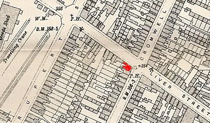
phil..looking at your second map...am i right in thinking that rupert st was never on the corner of cromwell st....think ive posted this pic before but is the caption correct.... it says wimbushes on the corner of cromwell and rupert st...

after a bit of research from mike this pic is on the corner of oliver st and cromwell st...thanks mike

lyn
 
Last edited:
Lyn
Cromwell st and rupert st never met . I think the picture must be of john wimbush, grocer at 60 oliver st, on the corner of Cromwell st. , as shown on the map. On a larger size map the gasometers are in about the right position, and the only other wimbush grocer (obviously not the bakers) is in a line of shops, not a corner. the shop stopped being listed between 1950 and 1955, so picture was after 1950.
Mike

map__john_wimbush__60_oliver_st_c_1914.jpg
 
Heres a photo of Oliver St that I don't think we have seen on here before. Its where it crosses over Rupert St and becomes Avenue Rd. I have many memories of walking down this road to my mate's house in Upper Thomas St.

I thought it was one of the creepiest roads in Birmingham, I don't think I ever saw another person on my many journeys up and down this road. It was always deathly quiet especially at night.

Phil

NechellsOliverStRupertStAvenueRd.jpg
 
Have just got back from a long day, Phil, not convinced it's Rupert St. , but there you go could be wrong.
I thought it may be Oliver St........
The junction of Rupert St. and Gt. Lister St, was at an angle which doesn't quite tie up with the photo.
I'm aware of the short stretch at the end of Rupert St., but still not convinced, I'm going to sleep on it.
Regards John.
 
Back
Top