• Welcome to this forum . We are a worldwide group with a common interest in Birmingham and its history. While here, please follow a few simple rules. We ask that you respect other members, thank those who have helped you and please keep your contributions on-topic with the thread.

    We do hope you enjoy your visit. BHF Admin Team

Gosta Green Through Duddeston

I ranted on not so long ago about a farm at the lower end of Henry Street, I think this is the one.
From " Images of England " Saltley, Duddeston and Nechells" by Maria Twist which has a wealth of Photographs.
ISBN 0-7524-2279-0
 
Last edited:
It definitely says Stevenberg in the directory, both the street and name section, but it wouldn't surprise me that they put it in wrong. Sometimes I've seen a different spelling in the street and th ename section, and in this case an r written quickly could very easily look like a v. It is only mentioned in 0ne directory I have, in 1921. In 1915 it was Parsons 7 wood, glassmakers, and in 1932 it was something completely different.
Mike
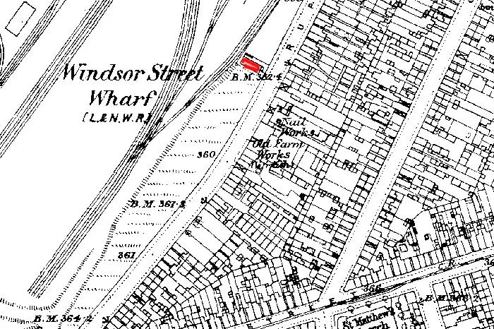
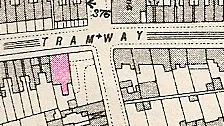
That's the street the name is spelt wrong, the "v" is a "n" Sterenberg that was New John Street,my mothers family were Dutch/Swiss .Rowlands was the Bakery where my aunt used to be a van driver, taking the bread to the bakers on the horse & carts. As a child I use to love the lst May when the bakery dressed the cart horses up in ribbons. The pub the New Inns was my uncles' favourite local, many a day I would have to go to the pub for a glass of bear for one of my uncles. My! that has brought back a few memories. I use to catch the bus outside the pub to school. Mike this is a reply from my friend,thank you
 
Ernie
It doesn’t exactly fit, but it is nearby and sort of fits with comment under photograph about being Farmer Garbutts, later occupied by the Perkins Family. In the 1880 directory there is;
Perkins John, varnish & paint manufacturer, Old Farm Varnish works, Rupert street.
This is shown on the street list (though there it just calls it the varnish works, no mention of old farm) as unnumbered but between nos 34 and 39, which should be roughly half way between Oliver st and Gt Lister st. this is marked “Old farm works" on the 1890 map. Might not the building in red be the old farm referred to below the picture (Perkin's house near the factory). It would fit with the factory being named “old farm”, as it was nearby, and I can’t see any other buildings on the map in the area which would have a rail line running so close (and at approx the right distance and angle) to rail lines, as shown in the picture. John Perkins varnish works first appears between 1868 and 1872 . I can’t find mention of an old farm before that , or a Garbutt farmer.
I think this fits the building in the picture, though it may not be the one you were thinking of.
Mike

perkins_varnish__works__c_1890_aspx.jpg
 
Lyn, I think it may have been on before , but then what's it matter. A lovely Photograph with lots of information on it.
I think it is an Italian family of the area.
 
ernie...at the back of my mind i thought it may have...yes you are right the family is italian...

lyn
 
I thought the picture looked pre WW1, but apparently not. Joseph is listed 1932-3, but not 1921 or 1936
mike
 
I was always a bit confused as to where I came from. Was it Nechells, Duddeston or Ashted , now I can see how close Nechells and Duddeston are.
 
These are two photographs of Ashted Row in 1961. I guess they are between the areas of Willis Street in the distances and Windsor Street or Heneage Street that crossed Ashted Row.( Saltley, Duddeston and Nechells) ISBN 0-7524-2279-0
 
Ernie if I remember correctly Dr O Keefe's surgery was the second house up past Willis St. He was our family doctor for all the time that we lived in Nechells.

Phil
 
Phil, My memory fades me now and I know he was along there, later to move down by the Clock ? pub near Bloomsbury Street.
I forget what he looked like all those years ago but he was such a nice Doctor.
 
Ernie

The way I remember it was he moved from the location in your photo to the new Health Centre in Denby Close off Oliver St in the early 60's. So did Dr Tighe who had moved his surgery in with Dr Topping. But as I remember he remained living in his house at the Junction of Ashted Row and Great Brook St until it was demolished. What a wonderful house it was. I still say it was a crime to demolish any of those houses on Ashted Row.

You can see how big Dr Tighe's house was in your photo (post 1719). Behind the wall was a courtyard garden and steps up to a large formal entrance. Through the double doors was an entrance hall with a double staircase to the upper apartments. I think today in another area you would be talking millions to purchase it.

Phil
 
Ashted row 1895

Ashted row,96 Belmont row ??????
to 1 Blooinsbury street.
MAP H 4, I 4.
1 Williams Edwd.furn.dealr
 
Last edited:
That a good old photo Ernie . Parliament Brewery on the pub don,t remember them but the building seems to ring a bell by the shape of the road i would say it was between Willis St and Henry St. Dek
 
The actual name of the pub is The Parliament House at 39 Ashted Row between Windsor St and Lawley St. It is marked in red on the map. Mr Green, who the picture refers to is Mr. West Green, shopkeeper at no 44 , which must be the house after the archway further up the street
Mike

map_c_1913_Parliament_house_pub_.jpg
 
I seemed to think it was in that area, what put me off was the pub that still stands today with the Ashted Row name plate on its wall. Also Ashted Row crossed over Dartmouth Street later to become Jennings Row.
 
This puzzles me as it says " Stood at the corner of Ashted Row and Great Lister Street.
Perhaps that can be corrected .
 
Ernie another great photo i must have walked up Ashted Row a 1000 times the best houses were down the bottom by Gt Francis St this one appears to have a small front garden. the only ones that i remember having front gardens were on the Bloomsbury St side between the Ashsted Cinema and the bottom of the Row.but the memory fades through time. Dek
 
Yes Dek, I seem to remember those gardens but thought they were more into Bloomsbury Street, I cannot say that I remember Ashted House too well. I cannot see that it would have been demolished before our time as I cannot think there would have been any waste ground where it would have stood.
 
Sorry about the spelling of the title.
This is a photograph of Great Lister Street with Saint Matthews Church in the distants.
 
Ernie

I certainly never heard of where Ashted Row met Great Lister St. Maria Twist must have got confused with Bloomsbury St. It could have been at the junction of Ashted Row and Bloomsbury St or the junction of Bloomsbury St and Great Lister St.

What you need is to get Mikejee to see if he can find it on one of his OS maps.

Phil
 
Another nice old one Ernie at first i couldn,t get my bearings but now i see that the site cleared is the position of one of the first tower block to be built in B,ham (not sure of the name i know South Tower stands on its own but always get mixed up with the other three). Dek
 
Dek. I could be wrong but I feel that the first tower block was built across the road from LIoyds on the corner in the photograph, I too could not tell you the names of the Tower Blocks.
I feel this site may well have been the beginnings of the Nechell's Parkway.
Come on mike get those maps out as Phil says, kick me if I am not asking you correctly.
 
Only a few early directories list an Ashted House, but it is no 90 Ashted Row. there seems to be some disagreement as to whether it was on the corner of or close to the corner of Ashted row with Willis St. the 1867 directoryis copied below, whereas the 1873 version is:

96 Tolley Mr William, gentleman

99 Popham Matthew, portrait paintr

90 Hands John (engineer)


........... Willis street.. .........

91 Cowney Frederick C. railway carriage body maker


The 1890 and 1914 maps are virtually identical, the 1914 map is given below, with what i think must be Ashted house in red.the numbering is consecutibve along the south side from left to right along ashted row

mike

90_ashted_row__c_1914.jpg
 
Back
Top