-
Welcome to this forum . We are a worldwide group with a common interest in Birmingham and its history. While here, please follow a few simple rules. We ask that you respect other members, thank those who have helped you and please keep your contributions on-topic with the thread.
We do hope you enjoy your visit. BHF Admin Team
You are using an out of date browser. It may not display this or other websites correctly.
You should upgrade or use an alternative browser.
You should upgrade or use an alternative browser.
Commonwealth Games, Birmingham 2022
- Thread starter Radiorails
- Start date
- Status
- Not open for further replies.
NoelleO 64
knowlegable brummie
Approaching the flyover from the aldridge rd, to wards the city. The walsall road traffic meets the now single lane aldridge traffic .who thought this one up?.40mph meets 20mph ? ???? .think l will go around the old crown and cushion island instead its saferThey are assuming everyone will want to cycle, or will now all be home-working
The outside of Selfridges is to be revamped for the Games.

 www.ikon-gallery.org
I prefer the old version, I think. this looks like something from a comic ( or graphic novel as the more illiterate members of the community call them)
www.ikon-gallery.org
I prefer the old version, I think. this looks like something from a comic ( or graphic novel as the more illiterate members of the community call them)
Osman Yousefzada designs a striking new installation for Selfridges at Bullring | Ikon
The iconic Selfridges building at Bullring is set for major renovation work beginning in Autumn 2020 with completion expected ahead of the Commonwealth Games in 2022. During this time, the building will be covered in a striking installation created by Birmingham-born artist
Brookfields Lad
master brummie
Isn't this a temporary covering for the scaffolding that has been erected?The outside of Selfridges is to be revamped for the Games.
I prefer the old version, I think. this looks like something from a comic ( or graphic novel as the more illiterate members of the community call them)Osman Yousefzada designs a striking new installation for Selfridges at Bullring | Ikon
The iconic Selfridges building at Bullring is set for major renovation work beginning in Autumn 2020 with completion expected ahead of the Commonwealth Games in 2022. During this time, the building will be covered in a striking installation created by Birmingham-born artist
Radiorails
master brummie
Certainly need dark tinted glasses when you look at that ghastly combination of colours. 
Isn't this a temporary covering for the scaffolding that has been erected?
thats the way i read it bob...its just a temporary covering..
lyn
What I cannot understand a decision which I now believe has been put back to December, and may well be put back further Is to have the clean air zone enforced by a congestion charge. One point of the zone I believe
starts around the inner ring road by the Newtown swimming, and fitness centre.m
So Perry Barr has all this so called up grade, but what ever way you come into the centre of Birmingham via Walsall Road or even College Road you will have to pay a congestion fee if your car is too old.
starts around the inner ring road by the Newtown swimming, and fitness centre.m
So Perry Barr has all this so called up grade, but what ever way you come into the centre of Birmingham via Walsall Road or even College Road you will have to pay a congestion fee if your car is too old.
Brookfields Lad
master brummie
Clean air zone won't start at Newtown baths on the Walsall road. The outer border for the zone is the A 4040 ring road.What I cannot understand a decision which I now believe has been put back to December, and may well be put back further Is to have the clean air zone enforced by a congestion charge. One point of the zone I believe
starts around the inner ring road by the Newtown swimming, and fitness centre.m
So Perry Barr has all this so called up grade, but what ever way you come into the centre of Birmingham via Walsall Road or even College Road you will have to pay a congestion fee if your car is too old.
Bob Davis
Bob Davis
Golly gosh, bright!!!!Isn't this a temporary covering for the scaffolding that has been erected?
Bob
Brookfields Lad
master brummie
The A4040 is the inner ring road.Bob I can be thick lol. So where is the A4040 Can you give me a landmark.
New John st, Icknield st, Ladywood middleway, Five Ways island to Bristol St, up Belgrave middleway, left to Camp hill island, Watery Lane, Lawley st to the end of Dartmouth st and the island where TK MAX is at New John st.
There is a detailed map on the Birmingham council website.
Brookfields Lad
master brummie
Big mistake on my part. The ring road number is A4540 not 4040.The A4040 is the inner ring road.
New John st, Icknield st, Ladywood middleway, Five Ways island to Bristol St, up Belgrave middleway, left to Camp hill island, Watery Lane, Lawley st to the end of Dartmouth st and the island where TK MAX is at New John st.
There is a detailed map on the Birmingham council website.
Brookfields Lad
master brummie
Glad to help.Thanks Bob I have been known to get lost when I drive especially with the Husband, by myself I stop and ask !!
 i am always losing my way
Brookfields Lad
master brummie
Yes to the old number 8 bus route.I think it Matalan Lyn, now I know what Bob’s talking about lol
So the old number 8 bus route was that at one time a ring road route?
Matalan..could be.
Places and road names cha he so quickly it can be confusing.
I think it Matalan Lyn, now I know what Bob’s talking about lol
So the old number 8 bus route was that at one time a ring road route?
hi diane here is a map of the inner circle 8 route...think i grew up on this bus lol...the route has not really changed that much..i would always catch it at the nursery road stop which is at the bottom of villa st where i grew up

Bob Davis
Bob Davis
Thanks, clearest map of the route I have seen.hi diane here is a map of the inner circle 8 route...think i grew up on this bus lol...the route has not really changed that much..i would always catch it at the nursery road stop which is at the bottom of villa st where i grew up
View attachment 148456
Bob
Brookfields Lad
master brummie
Here's a map of the A4540 ring road. This will be the congestion charge zone.
You will be able to drive on the A4540 without incurring a charge.
You will be able to drive on the A4540 without incurring a charge.
SmethwickGirl
Boing Boing!!
I live in Smethwick where the swimming centre is being built, in fact from my living room window I can see it, as I'm on the 10th floor of a tower block.
Sandwell council decided that, despite having plenty of brownfield sites locally with so many factories having been demolished, to put the swimming centre on a playing field in the middle of a housing estate, with no main roads nearby. It's been chaos since the start, traffic holdups, you name it in fact they have had to demolish a island and are, we think putting traffic lights there because it's been too difficult for the lorries to negotiate the island.
Because of the new centre, two well used and popular baths are to be closed, the one Thimblemill Baths is a beautiful building and also has a lot of local history as well, I'll find some links and post them.
Most residents round here were against the playing fields being used, but the council rode roughshod over what we wanted as usual. No doubt when it's all over, the council tax payers of Sandwell will be left with another huge white elephant because where it is just isn't practical. I can't see it being used for many major events, the car park isn't going to be that big and the bus that runs directly outside it, is half hourly during the day, hourly at night and Sundays and goes round the Wrekin to get tbere.
I'd take some photos, but I use a Kindle Fire to access the site and my phone runs with Google pictures and I can't see how to get them on here, if I can work it out, I'll take some.
Some links and pictures of Thimblemill Baths.
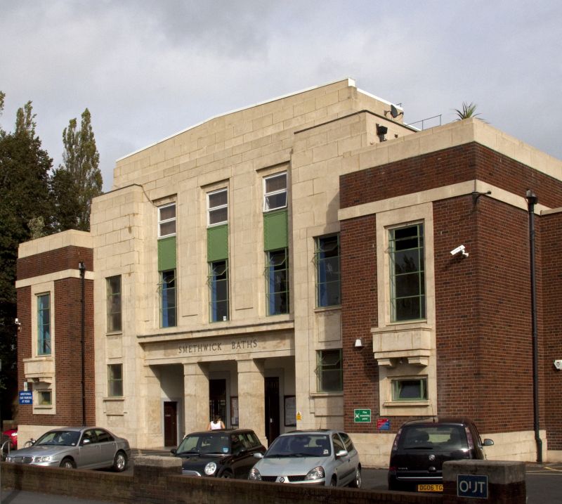
Smethwick Baths, Smethwick, Sandwell
Smethwick Baths is a Grade II listed building in Smethwick, Sandwell, England. See why it was listed, view it on a map, see visitor comments and photos and share your own comments and photos of this building.
britishlistedbuildings.co.uk
Radiorails
master brummie
The new Perry Barr station - what it will look like. As usual not everyone is happy.

 www.birminghammail.co.uk
Incredible new images revealed for Perry Barr railway station
The new station is set for a complete overhaul ahead of the 2022 Commonwealth Games
all of these sturdy houses from the entrance to the bus depot (which will also be demolished) on wellhead lane to aldridge road are all boarded up ready for demo...not counted them yet but looks like about 30

 www.google.com
Google Maps
Find local businesses, view maps and get driving directions in Google Maps.
Last edited:
Bob Davis
Bob Davis
Presumably compulsory purchase and the people had no option but to probably take the loss and find somewhere else, was there an outcry about it?all of these sturdy houses from the entrance to the bus depot (which will also be demolished) on wellhead lane to aldridge road are all boarded up ready for demo...not counted them yet but looks like about 30
Google Maps
Find local businesses, view maps and get driving directions in Google Maps.
Bob
not sure bob...those houses are directly in front of the bus depot which originally was all to be cleared for the games including building the olympic village but as we now know the council recently called time on that idea so they are just going to build new housing now. on the site of the old uni..i guess the deals with the owners of those houses was done well before the council pulled the plug on building the village...
lyn
lyn
perry barr flyover gone today
 www.birminghammail.co.uk
Watch - Perry Barr flyover reduced to rubble after 50 years of service
Controversial work is underway to remove the Perry Barr flyover as part of a £500 million regeneration scheme for the wider area
Makes me feel old. I came to Birmingham a couple of years before it was built
makes me feel even older mike...i was born in birmingham many years before it was built lol
lyn
- Status
- Not open for further replies.