
-
Welcome to this forum . We are a worldwide group with a common interest in Birmingham and its history. While here, please follow a few simple rules. We ask that you respect other members, thank those who have helped you and please keep your contributions on-topic with the thread.
We do hope you enjoy your visit. BHF Admin Team
You are using an out of date browser. It may not display this or other websites correctly.
You should upgrade or use an alternative browser.
You should upgrade or use an alternative browser.
Birchfield Road Perry Barr
- Thread starter debi
- Start date
The new school was in Livingstone Road and is still there. As for Enid I have been told that she went to
live in Cyprus. I have many happy memories of Enid Goodwins, took all my medals up to first Gold Bar standard and am still dancing now in my 70's. There are a lot of interesting posts on the Forum which make interesting reading.
live in Cyprus. I have many happy memories of Enid Goodwins, took all my medals up to first Gold Bar standard and am still dancing now in my 70's. There are a lot of interesting posts on the Forum which make interesting reading.
sophietherat
proper brummie kid
Hi All, I live at 367b Birchfield Road, above what is now Indigo Blue hairdressing (next door but one to where Dodds once was!) It's amazed me looking through this thread, and others. I've discovered that the wonderful "crown avenue" had once been a proper road instead of just an alleyway leading to my flat! I've found articles on other sites about Victorian ladies dying in my flat (which made for some sleepless nights!!). If anyone has anymore information on Crown Avenue, I'd be really grateful as I'd love to know what it was like as a road and not just a dead end!

oldMohawk
gone but not forgotten
I walked through Perry Barr hundreds of times well before the underpass was even thought of, in fact so long ago I caught the No 6 tram there. I must have seen that passageway and never knew it was called Crown Avenue. It just behind the car.
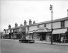
Photo date 1959
Photo date 1959
Last edited:
sophietherat
proper brummie kid
The map in post #106 shows it running parallel to the railway oldMohawk. I know old maps are a totally different proportion, but it looks like it's lined with houses! I know it was even narrower at one time, since the terrace at the edge was demolished. There's a lovely old bricked up archway just inside crown avenue. I'll get a few photos in the morning when I'm out and about!

The map in post #106 shows it running parallel to the railway oldMohawk. I know old maps are a totally different proportion, but it looks like it's lined with houses! I know it was even narrower at one time, since the terrace at the edge was demolished. There's a lovely old bricked up archway just inside crown avenue. I'll get a few photos in the morning when I'm out and about!
look forward to seeing the photos sophie..
lyn

Hi Sophie. I too would be interested to see any photos. I wonder if some of the Crown Avenue buildings on the map (above the words 'Crown Avenue') might have been connected to the railway. There's a group of 4 houses just below 'Crown' so there were residential buildings along there too at one time. But it's interesting how the Avenue peters out just before the allotments on the map. The allotments area - in fact that whole corner formed by the junction of Aston Lane and Wellhead Lane - was acquired by George Ellison's, which later became Tufnol's. Be great to see what we can find out about the Avenue. Posting the map section again so it's easy to see what I'm referring to. Viv.
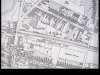

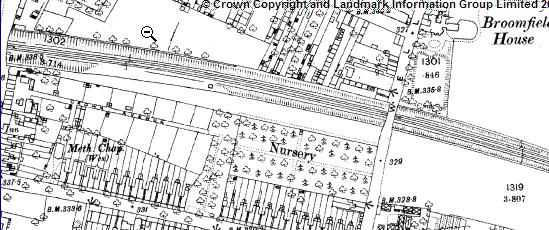
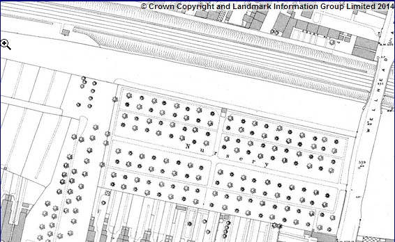
That's great Mike. I think we've discussed that nursery somewhere else on the Forum. Think it was an advert that described trips to visit it. Maybe it was in your 150 years ago thread. Sure it will come to me. Viv.
Thanks Mike. Here's your post (from the thread "From Birmingham Post 150 years ago").
The nursery was Mr J Cole's with it's entrance on Aston Lane. Looks easy to get to for a day trip if coming by train on the Grand Junction Railway to Perry Bar ( spelt with one 'r' only until Perry Barr station with two 'r' s was renamed - in 1894 when it became LNWR - info supplied by David Grain on the same thread). Excursions to buy strawberries, how sophisticated!
Now wondering if exclusionists were able to use Crown Avenue as an approach to Mr Cole's nursery. Looking at Mike's map, the main entrance would obviously have been on Aston Lane between, what is now, Tufnol's and the Cash & Carry Warehouse. But Crown Ave would have provided a quicker route from the station if it was possible to use it. Viv
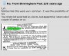
The nursery was Mr J Cole's with it's entrance on Aston Lane. Looks easy to get to for a day trip if coming by train on the Grand Junction Railway to Perry Bar ( spelt with one 'r' only until Perry Barr station with two 'r' s was renamed - in 1894 when it became LNWR - info supplied by David Grain on the same thread). Excursions to buy strawberries, how sophisticated!
Now wondering if exclusionists were able to use Crown Avenue as an approach to Mr Cole's nursery. Looking at Mike's map, the main entrance would obviously have been on Aston Lane between, what is now, Tufnol's and the Cash & Carry Warehouse. But Crown Ave would have provided a quicker route from the station if it was possible to use it. Viv
Yes, think you're right Mike, difficult to tell.
Here we have a glimpse of the houses/cottages on Crown Avenue, behind the Chapel on Aston Lane (see red dot). I extracted this from the very first photo on this thread posted by Astoness. (A brilliant aerial photo showing the major changes to allow for the widening of Birchfield Road). Also posting a section of the map showing position of cottages (red dot). Viv.
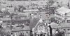
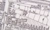
Here we have a glimpse of the houses/cottages on Crown Avenue, behind the Chapel on Aston Lane (see red dot). I extracted this from the very first photo on this thread posted by Astoness. (A brilliant aerial photo showing the major changes to allow for the widening of Birchfield Road). Also posting a section of the map showing position of cottages (red dot). Viv.
sophietherat
proper brummie kid
Viv, that's fantastic, I would never have spotted that! I've got a couple of photos of where I presume they would have been! I'll post them up when I'm at the computer!
sophietherat
proper brummie kid
Here's where my back garden should have been, Looking towards Tufnols. The long wall at the left of the photo is the back of Dodds. I presume this would have been a stockroom at some point?

That mystery archway! Bear in mind, the terrace at the end has been knocked down, so this would have been between 2 back gardens!?

Looking out onto Birchfield Road.

And finally, here's where I presume those little cottages were, where NTI is now.

That mystery archway! Bear in mind, the terrace at the end has been knocked down, so this would have been between 2 back gardens!?
Looking out onto Birchfield Road.
And finally, here's where I presume those little cottages were, where NTI is now.
That's great Sophie. So far I've had a look at the cottages/houses in relation to the NTI building and I think they're under the new building at this point - here's a comparison, not exact but gives you a rough idea. I think Crown Avenue would have continued right down the middle of the NT I building. I assume it now covers most of the original avenue. Viv.
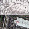
sophietherat
proper brummie kid
Viv, that looks about right. When Indigo Blue was next door to where it is now, before that god awful NTI building was there (I think it was built in about 2004) there were some smaller factory units, which I guess were part of tufnols. I've got an aerial view from then, which shows Crown Avenue going on a little bit further.

The line is Crown Avenue, although it doesn't really lead anywhere interesting, the dot is my flat, for reference with my photos from earlier, and the really badly drawn box is where I guess those cottages were!
The line is Crown Avenue, although it doesn't really lead anywhere interesting, the dot is my flat, for reference with my photos from earlier, and the really badly drawn box is where I guess those cottages were!
And here's the front view of those cottages/houses. Four in the terrace, with entrances fronting onto Crown Avenue. I expect the residents were gutted when Bill Switchgear built that factory next door. Canterbury Road School is in the foreground, now demolished.
Viv.
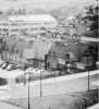
Viv.
Think we were posting at the same time Sophie. A good aerial view helps to get my bearings. Can't quite get my head around the bricked up arch yet but will give it some more thought. Finding it interesting. I can't draw squares either! Viv.
sophietherat
proper brummie kid
Ah Yes, it's Switchgears factory i'm thinking of being there until fairly recently, I think i'm pretty much spot on, as I think the big building behind that one that my wobbly box is on top of, is the old Switchgears?? I could be totally wrong, but I remember what was there before looking pretty similar. Having said that, i'm only a baby, and would have only been about 13 when that awful NTI building went up.
sophietherat
proper brummie kid
Viv, Having had a good look at your photo and my aerial view, I'm certain it's the old Switchgear factory I'm thinking of being there until about 2003, judging by the pattern on the roof, and that fire escape, that's between the 2 buildings in the aerial view.
Edited to add this link: https://ahistoryoftufnol.org/companyhistory/index.html
"In the early part of the 1960s a major investment in research and development led to the introduction of a whole series of new types of TUFNOL laminate, based largely on cloth woven from glass fibres bonded into laminates with new types of resin such as epoxy and silicone. To process these, a completely new impregnation plant had to be installed, a major new investment."
Could the unit that in 2003 covered the site of those cottages be this Impregnation plant?? In which case, i'd take a guess that those houses weren't there for much longer after the photo in post #349 was taken.
Edited to add this link: https://ahistoryoftufnol.org/companyhistory/index.html
"In the early part of the 1960s a major investment in research and development led to the introduction of a whole series of new types of TUFNOL laminate, based largely on cloth woven from glass fibres bonded into laminates with new types of resin such as epoxy and silicone. To process these, a completely new impregnation plant had to be installed, a major new investment."
Could the unit that in 2003 covered the site of those cottages be this Impregnation plant?? In which case, i'd take a guess that those houses weren't there for much longer after the photo in post #349 was taken.

sophietherat
proper brummie kid
Charlie, I presume you'd have been working at Switchgears at the time those cottages were there then!
I keep calling them cottages. They're actually quite big houses by the looks of them!
I keep calling them cottages. They're actually quite big houses by the looks of them!
I think the school shown is Birchfield Road Boys, Viv. Canterbury Road School is further up (towards Aston) and is still standing.
My first job was at Bill Switchgear c1957.
Oops thanks Charlie. Do you know if Bill Switchgear's was taken over by George Ellison/Tufnol? My dad worked for Ellison's and Bill S used to often pop up in conversations. I didn't think they were connected, but Geo Ellison's made switchgear too. And given their proximity, maybe they merged. But not sure. Can't find any reference to their connection. I remember passing Bill S's on the #11 bus down Aston Lane towards Erdington, but Ellison's/Tufnol's various buildings were further down at the junction with Wellhead Lane. Viv.
Viv, that looks about right. When Indigo Blue was next door to where it is now, before that god awful NTI building was there (I think it was built in about 2004) there were some smaller factory units, which I guess were part of tufnols. I've got an aerial view from then, which shows Crown Avenue going on a little bit further.
Sophie, I think you can just see the Bill Switchgear buildings in this ad to the right of your aerial view. Looks pretty big. Viv.

sophietherat
proper brummie kid
Viv, I'm pretty sure a lot of the old buildings are still there, now in use as Tufnols. You can see a lot from the train!
Edited to add: Ignore me, I've had a look at google earth and they're definitely not there anymore. I think I'm thinking of further up!
Edited to add: Ignore me, I've had a look at google earth and they're definitely not there anymore. I think I'm thinking of further up!
Hi Sophie. The arrangement of buildings behind the Birchfield Road shops is very confusing, so it's difficult to tell what's still there and what's not! I've been looking at the bricked up arch. Now I don't have a concrete answer, but looking at the Crown Avenue exit onto Birchfield Road, I think originally this exit was much narrower. Returning to the map 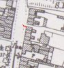
I think the building with the red (poorly drawn ! ) arrow, has been reduced or there's one less building. If you look at the roofline it seems incomplete.
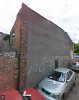
So I'm assuming the archway was part of the single level structure attached to the back of the building. Maybe the arch was cut in for a doorway into the neighbouring single level structure after the building was removed and the Avenue width was increased. Just a theory, wonder if anyone can add to this. Viv.
I think the building with the red (poorly drawn ! ) arrow, has been reduced or there's one less building. If you look at the roofline it seems incomplete.
So I'm assuming the archway was part of the single level structure attached to the back of the building. Maybe the arch was cut in for a doorway into the neighbouring single level structure after the building was removed and the Avenue width was increased. Just a theory, wonder if anyone can add to this. Viv.
sophietherat
proper brummie kid
1959
Viv, looking at this photo posted a couple of years ago, it looks like all of the end was Wilkins, so I presume as it was all one shop, they'd knocked through the yard too?
That's interesting Sophie, the chimney stacks have gone So I think that section of the terrace most probably was reduced. Viv.