• Welcome to this forum . We are a worldwide group with a common interest in Birmingham and its history. While here, please follow a few simple rules. We ask that you respect other members, thank those who have helped you and please keep your contributions on-topic with the thread.

    We do hope you enjoy your visit. BHF Admin Team
  • HI folks the server that hosts the site completely died including the Hdd's and backups.
    Luckily i create an offsite backup once a week! this has now been restored so we have lost a few days posts.
    im still fixing things at the moment so bear with me and im still working on all images 90% are fine the others im working on now
    we are now using a backup solution

John Street Dale End

W

Wendy

Guest
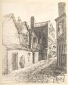
Here is a lovely drawing from Dent's book Old and New Birmingham. These were demolished around 1850 I think.

John_Street.jpg
 
Thanks for posting this picture Wendy, my g. grandparents gave John Street as their address on their marriage certificate 6th May 1867. No numbers though. I expect their homes were just as bad as those shown. It never ceases to amaze me what turns up on the Forum.
 
Sylvia
You do know, I take it that there were 3 John Streets in 1867, off Dale end, off Mosely road and in lozells. I'm pretty sure the state of the court in the picture would make it from the Dale end one, because it would be much older
Mike
 
Hi Wendy.
Thanks for the picture of John St. My Ancester Elizabeth Peters died at No 3 court John St in 1849 from Phithisis age just 55.
Malta.
 
Thanks for that info Mike I couldn't find in the book exactly where John Street was, I assumed it was replaced by New John Street
.
 
Wendy
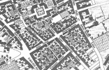
Below is a map c 1939 showing John St. court 2 was on the north side (counting from Dale End) . there were at least 5 courts on the north side, and i would guess court 2 was probably the one I ave marked in red (only an educated guess though)
Mike

map_c_1839_John_St__possible_court_2.jpg
 
Interesting to see where John Street was, and to see the sketch that Wendy posted as I found my 2 x great grandfather lodging in that street in 1841, when he was only 15 and (I presume) just come over from Ireland. He later moved to London Prentice Street which runs off John Street, as shown by Mike's map.

Judy
 
Thanks for the Map Mike I am sure you are right about the location. Not that far from the other picture I posted from Dents book in Steelhouse Lane.
 
I had several relations living just down the road in Court 1 in the 1850s. I have seen another picture of John Street which looks absolutely desolate; this one looks almost pleasant
 
Mike, it would be the John Street, Dale End, as on the 1861 census my g.g. grandparents, and family including my g.grandfather were living at 3 Dale End. My g.g. grandparents were born in Ireland, my g.g. grandmothers family were living at 9 Dale End in 1871 and they too were born in Ireland.
 
In 1862 3 Dale end was Thomas Walford, cheesemonger. Never heard that term before
 
my great-grandfather Thomas Brislin and his (widowed it seems) mom, Mary, and his wife-to-be (who was then a lodger), are on the 1871 census as at John St. - and it says 9 Court 5 House (I think).
There is a 10 further down the page, so I think it is 9.
But there is a 34 and a 35 in between on the page (confusing)
I'm sure it must be the Aston 'John St.' as all the back to backs, and dwelling places, they were at were in Aston.
Thomas is also in Court 6 John St. as a lodger in the 1861 census.
 
No Mazbeth, it was the John St in the city centre, as other streets in that district were Bull St, London Prentice St & Lower Priory. In the middle 19th century there were courts more to the centre of the town. It is Court 9 house 6, and the entrance to court 9 seems to be between no 34 and no 34. Possibly the entrance was through an archway through one building which was all no 34. I have no detailed map of that time, and by the 1889 map, the street was vvery different after the demolition and building which went with corporation st. However below is a 1839 map where the approximate position of court 9 entrance is in the area of the red line on the south west side of the street.

map_c_1839_John_St_showing_approx_position_in_st_of_court_9.jpg
 
.... It is Court 9 house 6, and the entrance to court 9 seems to be between no 34 and no 34. Possibly the entrance was through an archway through one building which was all no 34. ...

thanks Mike, that's very helpful.
I suppose I think of John St. (or at least New John St.) as being near the border of Aston and town (city centre), (like Staniforth St. was) as we used to walk it from Aston into town.
But it must be over the border then, into the city centre - or I may be completely mixed up about where it is.
Thanks for all your efforts in looking this up.
 
At the time you were talking about there was New John St and New john St West, which are both still there, and also the John St above, which later became part of Newton St, and also a John St off the Alcester Road.. The John St in Lozells did exist also, but as it was well outside hte city boundaries at that time, it was not mentioned in directories. Similarly there was a John St in Smethwick, though I am not sure if it was there that early.
 
My Great (x3) grandfather, John McLoughlin, lived in John Street in 1841 (Court 6, House 4). Close by lived my Great (x3) great-uncle (?), Roger Moraghan (writted as Morgan on the census) who lived at Court 6, House 5. My great (x2) grandfather, James Moraghan from County Roscommon, appears to have left Roscommon at the height of the famine in the early 1840's to live with Roger and his family in John Street. James married John McLoughlin's daugher, Ann, in 1850 at St. Chads Cathedral and on the 1851 census they are shown as living at Court 6, House 4 John Street (Morgan, rather than Moraghan, on the census). On the 3rd April 1854 James and Ann had their first child, Henry, who was born at Court 6 John Street. John McLoughlin died in 1849 and my Great (x3) grandmother, Mary McLoughlin, was shown as living at House 2, Court 10, John Street. On the 1861 census Mary is shown as now living at House 5, Court 11 John Street and on the 23rd January 1867 Mary died in Court 5, John Street of chronic bronchitis.

Sadly, Roger Moraghan (aka Morgan) and his family moved from John Street to Court 1, Steelhouse Lane where he died in 1871. The reason I use the word 'sadly' is that Court 1, Steelhouse lane was even worse than John Street and it also appears in the same book by Robert K Dent (mentioned at the beginning of this thread).

Court 1, Steelhouse Lane

134754

There's a very good 1750 map of Birmingham by Samuel Bradford which shows John Street following on from Newton Street ... http://mappingbirmingham.blogspot.com/2012/06/1750-map-of-birmingham.html

1750 Map of Birmingham
 
Last edited:
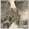
This drawing, possibly by James Burgoyne, is labelled as John Street on Alamy. On the corner is the Queens Head which is discussed on the Steelhouse Lane thread. I know from reading this thread that the section of this lane shown in the drawing, nearest Steelhouse Lane was Newton Street. The section nearest Dale End was known as John Street. So was Newton Street ever formerly part of John Street ? Personally I think it's probably a labelling error by Alamy.
Screenshot_20231024_132343_Chrome.jpg


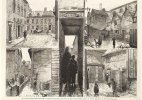
Some other info to add to this thread about John Street for those interested. This second image - and doubtless other drawings on this thread came with the caption ....

Screenshot_20231024_132612_Chrome.jpgScreenshot_20231024_132718_Chrome.jpg
A composite of the various views of courts on John Street
Screenshot_20231024_132242_Chrome.jpg
 
Last edited:
This drawing, possibly by James Burgoyne, is labelled as John Street on Alamy. On the corner is the Queens Head which is discussed on the Steelhouse Lane thread. I know from reading this thread that the section of this lane shown in the drawing, nearest Steelhouse Lane was Newton Street. The section nearest Dale End was known as John Street. So was Newton Street ever formerly part of John Street ? Personally I think it's probably a labelling error by Alamy.

The 1731 map has both John St and Newton St, so before that if at all.

0 - John St.png
 
I assume the building on the left is a chapel in John Street. But what chapel ?

View attachment 185376

Just noticed the composite image which included this image showing a chapel has the name marked as John Wesley's Chapel (writing is blurred but I think that must be it). But this doesn't strike me as being in John Street. I could be wrong though. Just have a feeling I've seen this somewhere else. Viv.
 
Back
Top