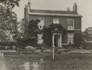
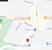
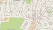
Using the Library of Scotland geo-referencing resource posted by Janice the overlaid maps in the first image below show where the House was (red dot) in relation to the retail park units. There seems to be two sections to the retail park (or perhaps they're two separate enterprises?).
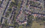
The House was just behind the shops on Hobmoor Road see the attached 2023 Streetview screenshot below. If it was still there today you'd have seen it through the gap between the shops. You can just see the corner of the retail unit through the gap, this would have roughly been the centre of the exterior wall facing Hobmoor Road. In fact if you dug up the carpark behind those shops I'd expect you'd find some clues to the former House ! Viv
View attachment 179316
View attachment 179317