• Welcome to this forum . We are a worldwide group with a common interest in Birmingham and its history. While here, please follow a few simple rules. We ask that you respect other members, thank those who have helped you and please keep your contributions on-topic with the thread.

    We do hope you enjoy your visit. BHF Admin Team

Then & Now

Here we have,

Baldwins Lane, Hall Green near Acheson Rd
Bordesley High St looking up Camp hill
Bristol St looking toward Begrave Rd
Hill St looking toward Victoria Square
John Bright St looking toward Navigation St
 

Attachments

  • Baldwins Lane Nr Acheson Rd.JPG
    Baldwins Lane Nr Acheson Rd.JPG
    124.7 KB · Views: 109
  • Bordesley High St looking toward Camp Hill.JPG
    Bordesley High St looking toward Camp Hill.JPG
    105.9 KB · Views: 108
  • Bristol St (2).JPG
    Bristol St (2).JPG
    128.3 KB · Views: 109
  • Hill St.JPG
    Hill St.JPG
    118.6 KB · Views: 110
  • John Bright St (2).JPG
    John Bright St (2).JPG
    114.8 KB · Views: 108
It seems strange to think we once had a coalmine at Hamstead on the border of Birmingham. A lot of miners from Durham moved there shortly before it was closed and many of them came to work in our maintenance shop, they were very handy with big hammers on our machines, and we found out what a Durham accent sounded like! I used to drive under the cableway in the mid 1960s and bought my petrol from the Shell garage on the left - the old Shell sign can be seen on a pole. One of the miners told me some of the workings went as far as the Kingstanding circle.

In the mid 1960s it was easy to drive to work.
hamsteadcableway1.jpg


Today as close as Streetview could get it.
More trees and of course more cars.
hamnow1.JPG
 
Being reminded of mining in Hamstead and the comment about the distance of the sub surface workings, made me wonder if there is subsidence to any large degree in that part of Birmingham. Being familiar with the Potteries, prior to the demise of most coal mines in the UK, I was aware that subsidence was a real problem in some places. One main road, in Longton, suffered greatly from it.
 
I used to drive past those colliery houses every day, always interesting to look at, I think the white building was some sort of chapel.
 
In the old days in Hamstead we had a Pit Mound which looked like a volcano. The old pic shows a rather bleak looking Langdale Rd with newly built houses and the 'volcano' looming in the distance. The modern pic looks more cheerful with trees and see the nearest house on the right still has the original concrete porch.

The slag heap was a major landmark !
Langdale.JPG

All cleaned up with the slag heap gone.

Langdalenow.JPG
 
I used to have picnics at Hamstead Colliery! It was a day out for us kids .... jam sandwiches and a bottle of pop, lovely - and we thought we were in the country!
 
Hi Charlie - fancy having days out at a colliery when you had the nearby Perry Hall Park to play in, and there was the canal which I skated on once. The nearby River Tame was interesting although it was virtually an open sewer back then with the Ray Hall sewerage works discharging into it and maybe the colliery also pumped some black water into it. The river is virtually clean these days so that's one improvement.
oldmohawk
 
Hi Charlie - fancy having days out at a colliery when you had the nearby Perry Hall Park to play in, and there was the canal which I skated on once. The nearby River Tame was interesting although it was virtually an open sewer back then with the Ray Hall sewerage works discharging into it and maybe the colliery also pumped some black water into it. The river is virtually clean these days so that's one improvement.te into our day out!
oldmohawk

Ah, but you see we could get a No16 bus from St. Mary's Church direct to Hamstead Colliery. We did use Perry Barr and Perry Hall park, but that meant a long walk along Putney Road/Livingstone Road to get the bus on Birchfield Road - or walk some more - and that ate into our day out.
So....idle option = Hamstead Colliery!
 
A few views of the Colliery through the years, and one of the view looking toward the Colliery slag heap from Hamstead Hill bridge in 1933.
 

Attachments

  • Great Barr Hamstead Colliery 2.jpg
    Great Barr Hamstead Colliery 2.jpg
    118.7 KB · Views: 58
  • Great Barr Hamstead Colliery 1954.jpg
    Great Barr Hamstead Colliery 1954.jpg
    169 KB · Views: 49
  • Great Barr Hamstead Colliery.jpg
    Great Barr Hamstead Colliery.jpg
    64 KB · Views: 52
  • Handsworth Hamstead Hill Bridge 1933.jpg
    Handsworth Hamstead Hill Bridge 1933.jpg
    199.2 KB · Views: 56
Hi All,

Bearing in mind the terrrible tragedy at Aberfan many years ago can anyone tell me what happened to the slag heap at Hamstead? Is it still there?

Old Boy
 
A few 'then and now' images and comments about Hamstead.

This first pic is a 1965 view of an engineering factory and offices near the railway station. On the left is a high chimney which was part of the brick works situated behind Rocky Lane and Colleraine Road. The pic is scanned from an old photo copier print so resolution is low.
bex.jpg


A comparable streetview is not possible because the company built a large office block in front of the buildings in the above pic. An aerial view shows the office block in front of the old building and factory and the old bridge shown in Phil's 4th pic in post #193 is just visible through trees to the left of the main road. I remember seeing the main road competely closed due to flooding in the mid 1960s.
hamstead.jpg


In this 1945 Google Earth view, I've marked where I think the slag heap was. Modern roads are overlaid on this view and some of them did not exist in 1945 including Langdale Road which is shown in post #188. I think the colliery slag heap was removed in the late 1960s and today's aerial view shows houses have been built there.
mound.JPG


The engineering factory mentioned above was closed about 10 years ago and the machines shipped overseas and the buildings have been demolished and site cleared for a new supermarket. https://www.j-sainsbury.co.uk/about-us/property/supermarkets/midlands/hamstead/
 
Hi All,

Bearing in mind the terrrible tragedy at Aberfan many years ago can anyone tell me what happened to the slag heap at Hamstead? Is it still there?

Old Boy
Hi Old Boy - There is some information about the slag heap which is shown in a painting in a forum post here https://birminghamhistory.co.uk/forum/showthread.php?t=38988&p=443817#post443817
and a photo which shows another view of the heap in a forum post here https://birminghamhistory.co.uk/forum/showthread.php?t=38988&p=444150#post444150
 
A few more old photos accompanied by images of what the same scene looks like today. Here we have,

Kingstanding Circle
Edmund Street in the City
Suffolk St in the City
Queens Drive, New Street Station
Alms Houses Conybere Street Balsall Heath
 

Attachments

  • City Queens Drive.jpg
    City Queens Drive.jpg
    155.9 KB · Views: 113
  • s Trust.jpg
    s Trust.jpg
    129 KB · Views: 107
  • City Suffolk St.jpg
    City Suffolk St.jpg
    147.7 KB · Views: 103
  • Edmund Street (2).jpg
    Edmund Street (2).jpg
    322.4 KB · Views: 108
  • Kingstanding Circle.jpg
    Kingstanding Circle.jpg
    240.8 KB · Views: 114
Here a few more,

The Dolphin, Warwick Rd, Acocks Green Now an Aldi & Farmfoods
The Hall of Memory & Baskerville House
Bromford Lane - Wheelwright Rd Junction Erdington, only the hoarding remains
Beeches Rd - Hassop Rd junction Great Barr
Camden Street - Ellen St, Hockley or is it Brookfields?
 

Attachments

  • Acocks Green Warwick Rd Dolphin Inn - Adli Supermarket.JPG
    Acocks Green Warwick Rd Dolphin Inn - Adli Supermarket.JPG
    104.8 KB · Views: 109
  • City Broad St Centenary Square.JPG
    City Broad St Centenary Square.JPG
    92.7 KB · Views: 113
  • Erdington Bromford Lane - Wheelwright Rd.JPG
    Erdington Bromford Lane - Wheelwright Rd.JPG
    81.6 KB · Views: 110
  • Great Barr Beeches Rd - Hassop Rd.JPG
    Great Barr Beeches Rd - Hassop Rd.JPG
    83.4 KB · Views: 103
  • Hockley Camden St - Ellen St.JPG
    Hockley Camden St - Ellen St.JPG
    117.3 KB · Views: 109
Last edited:
Sorry but the Hall of Memory area now looks so "cold". No grass for the Council to cut I suppose and next best thing to concrete!

Maurice
 
Maurice

All through this thread I have to say that I much prefer the "then" photos to the "now" photos. In the main I think modern architects have lost the plot.
 
I too prefer the then to now photo's, clean, tidy respectable times. The buildings being stylish, not like now.

Chris
 
I remember going with my dad to the "Hall of Memory", as kid, in summer the lovely gardens all laid out and we would sit for ages in the sun in that beautiful place. Times move on and the only thing driving councils now is cost hang public amenity. Paul
 
What Have they done to our pubs?

Here we have 5 long established pubs that were deemed surplus to requirements, some were demolished and some were utilised for other purposes.


The Summer Hill Tavern once very popular with ice skaters now a Chinese Restaurant
The Bell Vue on Icknield Port Rd now a Coffee Bar and Living Accommodation.
The Broadway Bordesley Green now a MacDonalds
The Gothic Constitution Hill, nor sure what it is now but pink & white is hardly gothic
The Red Lion Acocks Green, now a supermarket but there is still a one room bar on the site.
 

Attachments

  • Summer Hill Tavern.JPG
    Summer Hill Tavern.JPG
    167.5 KB · Views: 90
  • BelleView.JPG
    BelleView.JPG
    87.9 KB · Views: 84
  • Broadway (2).JPG
    Broadway (2).JPG
    275.3 KB · Views: 93
  • Gothic.JPG
    Gothic.JPG
    98.9 KB · Views: 90
  • Red Lion Warwick Rd.JPG
    Red Lion Warwick Rd.JPG
    92.3 KB · Views: 89
Last edited:
Another type of building I bemoan the fact of losing are churches, although not being the slightest bit religious I can still appreciate a beautiful building no matter what it s used for. These are just a very few of the churches we have lost over the last century and this.

Acocks Green Congregational Church, Stockfield Rd
Christchurch Victoria Square
St Mary Aston Road North
St Pauls Moseley Rd Balsall Heath
St Thomas Cox St West Balsall Heath
 

Attachments

  • Acocks Green Congreagational Church Stockfield Rd.JPG
    Acocks Green Congreagational Church Stockfield Rd.JPG
    252.5 KB · Views: 68
  • Christchurch Victoria Square.JPG
    Christchurch Victoria Square.JPG
    133.3 KB · Views: 66
  • St Mary Aston Rd North.JPG
    St Mary Aston Rd North.JPG
    105.7 KB · Views: 76
  • St Pauls Moseley Rd Balsall Heath.JPG
    St Pauls Moseley Rd Balsall Heath.JPG
    125.7 KB · Views: 69
  • St Thomas Cox St West Balsall Heath.JPG
    St Thomas Cox St West Balsall Heath.JPG
    218.8 KB · Views: 67
Phil. It is pure unnecessary legal vandalism and destruction.

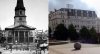
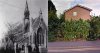
Here in Norwich, we have over 52 churches, and we are rather proud of them. To the best of my knowledge, none have been destroyed, but put to other good uses. The old churches are part of our tradition, and Norwich seems to thrive on its reputation for conserving old buildings.

I have been back to 'Brum', and noticed much change, not in my opinion, always for the better. I love visiting old churches. There always seems to be a wonderful atmosphere, and feeling of history.

My wife and I were married in a most beautiful Norwich church, and I still find great enjoyment when I pass it, and that is in spite of nearly 55 years married! (joking).

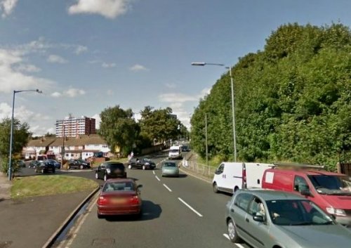
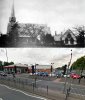
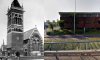
Churches are our heritage, and it is a heritage that is being destroyed. Perhaps Birmingham City Council could learn a few lessons from 'Little 'ol Norrich', but I very much doubt that B.C.C. would heed advice from any one.

Eddie
 
I think what we lose when a local church is demolished is the local history of the parish, they are a micro-collection of the social history of the area, like Eddie I love walking round church's and reading the area family's and vicars who have served there in the ages gone by.Paul
 
Back
Top