• Welcome to this forum . We are a worldwide group with a common interest in Birmingham and its history. While here, please follow a few simple rules. We ask that you respect other members, thank those who have helped you and please keep your contributions on-topic with the thread.

    We do hope you enjoy your visit. BHF Admin Team

The Lodge to Thornhill Road

mikejee

Super Moderator
Staff member
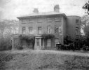
This Photo in birmingham Images is Labelled "Description:The Lodge House to Thornhill Road which was the house of Miss Anne Boulton, daughter of Matthew Boulton, built in 1826. In 1881 Thomas Wetherley, a 55 year-old gardener lived here with his wife and son.".
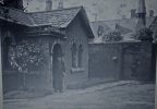
Lodge to Thornhill road  1881A.jpg

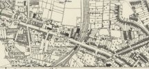
Here is a map from a little after , in 1887. I am not quite clear where the photo was taken , but it is obvious that the House must be the one at the end of the Road
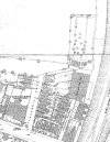
map 1887 showing Thornhill Road.jpg
 
I was just wondering that!
There was a Police station in the Handsworth one wasn't there, that's what I associate it with!
yes police station still there sparks...looking at mikes map again i can just see where it says soho handsworth on the right so it must be that one

lyn
 
More on the Lodge here....

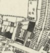
A large 5-bay Georgian house stood between what is now Waverhill Road and Holliday Road in extensive grounds. Thornhill House was bought by Matthew Boulton in 1793 and subsequently let to James Watt Junior who had it refurbished.
1818 Boulton's daughter Ann moved in when Watt moved to Aston Hall. By 1829 the house was in use as Handsworth Technical School. It was demolished in 1900.

1355788600.jpg

From this page..

The house looks different from mikejee's photograph but maybe taken round the back?
 
Last edited:
hi sparks i dont think thats our lodge which was on thornhill road...the link you posted is about thornhill house which was between waverhill road and holliday road unless i have miss understood your post which is quite possible...lyn

Ah yes, sorry!
It was the mention of James Watt's daughter Ann living there on both photos that confused me.
 
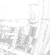
The 1880's OS Map showing Thornhill House. Thornhill Road has not yet come into existence. Surveyed 1886-88.


View attachment 200619
The map I posted on post 1 is the same map , but on a larger scale. I assume that there dates given by the OS are correct (1886), so the photo must have been taken somewhere at the end of Thornhill road, which is named on the larger scale map
 
I don’t think it is the same map but the same date, as Thornhill Road is not named on the one in post 12. However there is a gap in the houses, after the Almshouses where there is a Trig Point, this could well be Thornhill Road as it is mentioned as early 1881.

(The Almshouses were constructed in 1874)
 
Yes, the map of lesser scale in post 12 shows the situation of Thornhill House in relation to the Lodge. It is in addition to map of larger scale and the existence and position of Thornhill Road acknowledged to exist prior to the issue of the map in at least 1881.
 
Back
Top