
-
Welcome to this forum . We are a worldwide group with a common interest in Birmingham and its history. While here, please follow a few simple rules. We ask that you respect other members, thank those who have helped you and please keep your contributions on-topic with the thread.
We do hope you enjoy your visit. BHF Admin Team
You are using an out of date browser. It may not display this or other websites correctly.
You should upgrade or use an alternative browser.
You should upgrade or use an alternative browser.
The Great Stone Northfield
- Thread starter mhemery
- Start date
Just to add that the same story of the allegedly criminal but no doubt kindly rector appears in the Smiths' book "Northfield Past & Present", Sutton Publishing, 2001 pp 16-17. They also say "The 18th century saw the introduction of poor boxes into the Church in 1707. Previously there had been collections for the poor and needy. The unemployed, to obtain assistance, were obliged to stand for a specified time each day in the village Pound". Unfortunately, no references provided. Nevertheless it is a perhaps timely reminder that the Welfare State has it's advantages!This article (#18) is very interesting, Viv. Elias Clarke (recorded as Elias Clerke, pbr.) was instituted as Rector of Northfield on 17 March 1438 but I can't find any reference to his having broken into the Pound although struggling with manorial records is confusing! Wouldn't that have been a bit scandalous for a rector? Did rectors typically own livestock?? I wonder if anyone can resolve this because it's perfectly reasonable to suggest that the Pound was originally late medieval in origin (like the neighbouring original building that became the Stone pub) and that it was later modified in the 17th century as opposed to being first built then. (https://britishlistedbuildings.co.uk/101343382-village-pound-ward suggests c 17th century origin)
Last edited:

Pedrocut
Master Barmmie
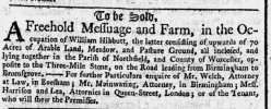
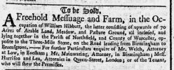
November 1761, Aris’s…could the Three-Mile Stone be an early mention of what we now call the Great Stone ? (Or just a milestone)
(SORRY…The post was inadvertently placed under “what number bus” !) Edit, now moved to this thread.
The Three-mile Stone is more likely to be a milestone, as later there is a reference to a Four-mile Stone. The earliest mention of the Great Stone Inn I can find is 1812.
(SORRY…The post was inadvertently placed under “what number bus” !) Edit, now moved to this thread.
The Three-mile Stone is more likely to be a milestone, as later there is a reference to a Four-mile Stone. The earliest mention of the Great Stone Inn I can find is 1812.
Last edited by a moderator:
I agree that the Three-Mile Stone is just a milestone and would have sat close to what is now Selly Oak and so wouldn't have been associated with the Great Stone. According to Project Gutenberg's A Description of Modern Birmingham, by Charles Pye 1818: "A short distance beyond the three mile stone the road crosses the Worcester canal ..... Having passed the five mile stone, there is on the right a beautiful view over the enclosures, backed by the beeches, at Frankley. Before you arrive at the six mile stone is Northfield, from whence there is on the left a beautiful landscape; the elegant spire of King's Norton church being distinctly seen. From hence to Bromsgrove is seven miles... "
Last edited:
Birmingham Civic Society presented a plan for the conservation and road redevelopment of Northfield Village in 1920 and produced a picture map which shows the layout and their proposals at the time (The Work of Birmingham Civic Society June 1918 - June 1946 pp28-29) and it is still an interesting insight even though the recommendations weren't accepted by the Council:
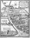
For more details see: https://northfield-uk.blogspot.com/2015/07/civic-society-plan-for-northfield-in.html
For more details see: https://northfield-uk.blogspot.com/2015/07/civic-society-plan-for-northfield-in.html

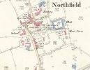
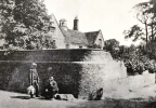
Both maps above mark the Old Rectory and it's shown below in the 1920s along with two passing gents who remind me of Vladimir & Estragon in Waiting for Godot! Godot never showed up and neither did redemption for the 18th century Rectory. It was demolished in the 1930s having been declared so dilapidated as to be unrestorable by a narrow vote (13 to 11) of the Church Council despite a vigorous and well documented campaign by Birmingham Civic Society to preserve it. The site is now occupied by the St Laurence Pastoral Centre:
Yes - I think the term “Old Moat House” really refers to the moated manor/farmstead at Moat Farm which stood near St Laurence Church. Old Moat Drive by the church is named after the moat, 60m square at Moat Farm. It was levelled in 1930 and houses were built on the site in 1965. This may have been the site of Northfield manor house from the 11th century to the 14th century before Weoley Castle superseded it.I noted that the Moat lasted a long time but is now Old Moat Drive...
According to AF Williams (see:https://northfield-uk.blogspot.com/2015/07/civic-society-plan-for-northfield-in.html ) "in 1930....the Tithe Barn, much dilapidated, was still in use at Moat Farm. But in this year the Moat itself disappeared, Haywood's account * being that "the Rector allowed the Public Works Department to use it as a dump for road waste". To this it is fair to add that the local resident Mr. G.A. Hemus (whose booklet The Story of Northfield was published in the nineteen-fifties) suggested that the Moat was filled in 'because of its danger to children who, often being too venturesome, would fall in and get a wetting' ". *William Hayward was the then Hon. Secretary of The Birmingham Civic Society.
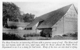
(Hayward, W. The Work of Birmingham Civic Society June 1918 - June 1946 p30)
Last edited: