• Welcome to this forum . We are a worldwide group with a common interest in Birmingham and its history. While here, please follow a few simple rules. We ask that you respect other members, thank those who have helped you and please keep your contributions on-topic with the thread.

    We do hope you enjoy your visit. BHF Admin Team

Street furniture

  • Thread starter Thread starter Kandor
  • Start date Start date
Now I was always under the impression that Belisha Beacons had an accompanying zebra crossing. But no, this one on Broad Street stood alone. And the second one in Corporation Street seems to have half a crossing (or maybe it's out of view). Viv.

View attachment 90174
View attachment 90175

October 1951, when the Ministry reacted to complaints that the crossings weren't sufficiently visible by ordering that they should have thick white stripes painted across the road to leave motorists in no doubt. Because they now had a set of black and white stripes on the road to match the ones on the Belisha Beacon poles, they were renamed Zebra Crossings,
 
Thanks Nick. I did wonder how visible pedestrians would be crossing at those points. The stripes must have been a great improvement. I don't think I'd have been too confident crossing at this Navigation St/ Hill St junction. Can't tell if there is a Belisha Beacon on both sides of the road but I assume they came in pairs. Viv.

ImageUploadedByTapatalkHD1386000023.171180.jpg
 
Regarding the Fire alarms fitted on the streets, I remember there was one at the junction of Paget Road and Tyburn Rd where the LollyPop Man took us kids across the Tyburn Road - and I was almost killed dashing back into the road to pick up a book I had dropped. Amazingly the Lollypop man did not give me a thick ear, I imagine he was waiting for his heart rate to return to normal.
What about the large blue milk machines? 6d got a third (?) pint carton of chilled milk or, even better, a strawberry milk shake. There was one by the shops at the Bagot Arms until the mid sixties when vandals started attacking it.
Re the Belisha Beacons, I think they were named after the man who thought of them, Lord Belisha. So much more user friendly than those awful Pelican crossings we are now saddled with.
 
I remember cast iron water pumps you either pulled the knob out or turned it, the excess water falling in to the drain below. I still like the sound of them. Some seasides still have them and are still found abroad. I also like 'prom' railings. Usually painted blue, and cattle grids and clap gates. I was told Cov had clap gates till the fifties in the town and suburbs as the slaughterhouses were in the town. I also liked those oblong paving slabs with a long indent where you could park your bikes.
 
Another one of those large concrete bollards, this one in New Street between the nice street lamp and the elegant lady with the sunshade.
No articulated trucks cutting corners in those days so what was it for ?
NewStreet.jpg
 
Last edited:
Hi Hansonbridge. Those milk machines surely would be viable today. But as you say, they attract vandalism. Pity because they'd come in handy. Does make you wonder why some things attract vandals, whilst others don't.

Hi Nico. Drinking fountains do seem to be a thing of the past too. Think we have one in our local park, but can't think of any others.

Hi Phil. I have a theory about that bollard, probably wrong tho. Maybe it was to stop vehicles from smacking into that gas lamp next to it. Viv.
 
There used to be a terminus clock for the number 11 in Church Road Handsworth. If you got stuck on that bus you sometimes had to wait 10 mins or so for the driver to finish his fag and key in and get moving again. Happy days - a lot slower than today.
 
Hi Paul - You might be right, it makes one wonder about the history of the one on the corner of Longmore St in the pics here, it had survived until the 1960s.

Thinking back there were a lot of these dotted about when I was young, I think we just took them for granted without questioning their original use. Just something that disappeared without us really taking a lot of notice, like horse troughs, drinking fountains and those rows of granite sets along the gutter on tarmac roads, and indeed what we called cobbled streets
.
 
An unusual looking piece of street furniture on a street corner in a forum pic of New St dated 1939.
Click on it to see - it might have a twin on an opposite corner !
 
Last edited:
From the various posts bollards seem to have a very long history then. I'd assumed that they came into being in Victorian times with increased traffic but they seem to have been around much longer. Re the photo extract posted by Phil in post #64, the bollard on the opposite side of the road looks like a young boy waiting to cross, but obviously it wouldn't be at that time of night. What a lot of street furniture in that photo. And what a variety of bollards. Seems a bit cluttered by today's standards. Viv
 
The question is what is it ? Could it be an early form of pedestrian control of the crossing ?
I'll have to have a look at other pics of that crossing.
 
Great busy scene maybe earlier than 1939 because the traffic is two way. The objects in the pic look different but are maybe earlier versions or maybe different purpose but something connected with the pedestrian crossings. I've been slacking tonight watching the football on BT Sport, but multi-tasking with this post !
 
I've had a look at quite a few New St/ Stephenson a Place/ Corporation St junction photos and on almost all of them this is a phenomenally busy junction. So I think you're right that it was pedestrian related. It's an interesting shape on top but I can't find anything like it from a quick search. I also wondered if it was yellow in colour. Viv.
 
Like Old Mohawk I think the picture is before 1939. King Edward's Grammar School was starting to move out in 1936 and was subsequently demolished.
 
Last edited by a moderator:
Now in those far off days of horse drawn transport, with all that equine effluent filling the streets, could the bollards have been to there merely to indicate where the horseroad ended and the pedestrian pavement began:friendly_wink:
 
Could be a reason Paul. I've just run a scan of the forum's New St pics for bollards and found two although rather unexciting.
One on the left in the 1st pic and on the right in the 2nd pic
index.php

index.php
 
Last edited:
I believe the bollards were a pedestrian protection item as horse drawn carts were often a law unto themselves and it seems your feet and legs were far more susceptible to injury then than today. The bollards I am sure were silver and vehicle segregation bollards, often lit, were white, later white/black I think. WW2 changed them somewhat. The 'cross now' sign was usually placed where traffic control signals were and as such gave you a sporting chance of crossing the road. Where the police controlled traffic there were far less jay walkers: a bane today in many places. :rolleyes:
 
Thanks for the information, roly.
I hadn't realised there were so many "48s" !
The "48L" interests me, assuming it terminated at Warstock Rd, a dual carriageway, do you know where the terminus would've been ?
(When I was a tiddler the bus to the Maypole was the No. 35).

Hi Maypolebaz.

I would think that the 48L and 50L would have set down its passengers at the stop outside the horseshoe pub (the bus stop, I remember, was on a wonderful old lamp-post with scroll work and a lovely box lantern -which was there until 1976!) and then turned using the U-turn facility in Warstock Road (opposite Limekiln Lane) and took up service on return to the city at the stop by the canal bridge. Although schedules existed and Warstock Road appeared on destination blinds it was probably rarely or never operated - being so close to Maypole.

I went to Maypole school and I have the old bus stop from outside the school gates. Whilst gazing out of the window one afternoon in March 1978 I saw workmen changing the bus stop over so I dashed out of class and out of school and charmed it off them!

Incidentally, the 35 to Maypole started out as a 17 and ran cross city (limited stop) to Erdington in March 1928. It was re-numbered to show 17 to Erdington (Chester Road) and 35 to Alcester Road (Maypole) in Aug 1936. In Sep 1939 it was curtailed to operate City - Maypole as a wartime measure and never re-instated. This lasted until Oct 1949 when the 35 route disappeared with the Moseley Road trams being replaced by the 50.

The 35 was to re-appear in 1965 as a one-man single deck service between Brandwood Park Road and King's Heath. I lived by the BPR terminus and remember a variety of different buses on it.

sorry - rambling again and going off topic.
 
Looking again at this early New Street pic (in #72), some trestles show in the kerb areas and the ones on the left side are joined by bars, and I think the ones on the right side are but don't show because of the brightness. On the left side a space can be seen from which a carriage is pulling out, and on the right side another space shows in which a carriage is parked.
Are these the earliest parking/loading restrictions seen in Birmingham ?

index.php
 
Last edited:
Thanks all for the info being posted. Hadn't realised bollards could prove so interesting.

Phil I too was trying to work out what the bars were for on your photo. Thought they might have been a temporary thing, like the temporary fencing that's put in place when there are street parades. But your idea seems much more likely. Was wondering if they removed the top bar when 'parking' in a bay. Viv.
 
I have seen something like that in the past when road works barriers were solid wood often red and white srtipes with little red lanterns with candles in them hung on the top. When they had the road up. Mayne that's what they are and were about to dig?
 
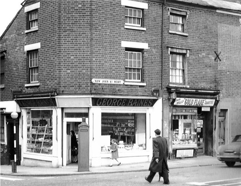
Moving on from the 'Bollards' theme, here is an interesting item of street furniture in New John Street West.
New2520John2520St2520West2520corner2520of2520Gt2520Hampton2520Row_.jpg
 
The police phone box is on a street corner, like the one in post #2. So were these usually on street corners/junctions? Viv.
 
Also wondering whether police phone boxes, fire pillars etc were ever marked on maps. I have a vague idea public phone boxes were marked on maps, but not sure if emergency services were too. Viv,
 
Back
Top