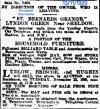
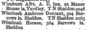
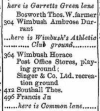
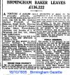
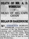
In 1950's 60's there were playing fields at the rear of St Bernards Grange, can't remember who played there, could have been Hardy Spicer but not sure. Langham Close must have been cut when the houses were built, the "Grange" was always on Barrows Lane "back in the day".This is located at Langham Close, Lyndon Green, Sheldon. It's a former manor house, subsequently owned by the proprietors of the A.D. Wimbush & Son Bakery group, and then a breeding kennels for St Bernard dogs. Presumably, that's how it got its name. What was tge original name of the manor house ?
The exterior looks in a better condition today than it did in the B&W photo (1930s/40's ?)
View attachment 203471
View attachment 203473
No one has added to the dog breeding reference, perhaps it's an urban myth or fake news?This is located at Langham Close, Lyndon Green, Sheldon. It's a former manor house, subsequently owned by the proprietors of the A.D. Wimbush & Son Bakery group, and then a breeding kennels for St Bernard dogs. Presumably, that's how it got its name. What was tge original name of the manor house ?
The exterior looks in a better condition today than it did in the B&W photo (1930s/40's ?)
View attachment 203471
View attachment 203473
ahh right viv in that case ive moved this map down a bit to show st bernards and your blue dot could be about rightJust to be clear, I'm referring to St Bernards Lyn in post #26. The blue dots being where I think St B Grange is. All a bit guesswork as the maps are a bit too close on the edge to get proper bearings.
The Pub on Church Rd, up Barrows lane, was destroyed by fire can't remember the namewould have thought viv if it was destroyed by fire it would have said so....my feeling it was delmolished ..lots of re developement in the 1930s....ahh yes just noticed janices post 22 sold for development...how sad is that but its happened many times..probably not thought important enough to put much in the papers as ww2 was looming upon us
lyn
Theres a gully behind the houses in Larne Road and Kennedy Croft. It follows the route of the track in the farm photo. I've marked it in yellow below and rotated the map to match the image in post #16. Was this an access route (and not a road) for the building of the houses in the 1930s? If so, were the houses we see in this view in the photo a rear view of...Another view of the farm (left). Possibly some housing just visible beyond the farm buildings. Maybe this was just as building had started on 1930s housing in this area and just prior to the demolition of the farm.
View attachment 203771