• Welcome to this forum . We are a worldwide group with a common interest in Birmingham and its history. While here, please follow a few simple rules. We ask that you respect other members, thank those who have helped you and please keep your contributions on-topic with the thread.

    We do hope you enjoy your visit. BHF Admin Team

Spring Hill

Hi Lyn. Thanks for looking and responding. The premises were neither a shop or house but probably some sort of administrative or religious premises. It was in the region of numbers 1 to 20 just down from Monument Road near to the record shop. I am going back to the 50’s here. From memory I think there were metal gates and I had it in my mind that it was a synagogue or other Jewish premises, but I can find nothing at all about such a building. If anyone could throw some light on this I would be very grateful.
Frank
hi cranky so actually on monument road then ? i will search my photos to see if i can find any sort of religious premises and maybe someone could check the kellys directories for you...i think we have a thread for monument road have you checked it out also was the building you are searching for on the left or right of monument road looking towards spring hill library

lyn
 
Last edited:
hi cranky so actually on monument road then ? i will search my photos to see if i can find any sort of religious premises and maybe someone could check the kellys directories for you...i think we have a thread for monument road have you checked it out also was the building you are searching for on the left or right of monument road looking towards spring hill library

lyn
Sorry Lyn I have misled you. The premises I am looking for were on Spring Hill on the stretch just down from the Monment Road junction heading towards the Dudley Road
 
Sorry. I was going by your original comment about it being around nos 1 -20
I seem to have confused everyone in trying to explain the location of the place I am interested in. Just to clarify : - if I was walking down Monument Road towards the library and then turned left into Spring Hill, the premises in question would be on this part of Spring Hill between Monument Road and Ingleby Street. The numbers of the buildings in this area are in the region of 1 to 20 Spring Hill. I appreciate the speed of response and the assistance you have all provided. It appears to be a great forum
 
phil is that spring hill running up...would you have a shot which includes spring hill library please as its numbers 1 to 20 spring hill that is of interest...thanks phil

lyn
 
Lyn,
As I see the view from the Library which is in the centre of the photo
Springhill runs to the right
Monument Rd towards the top left
Summerhill Rd to the left.
Unfortunately I haven't got a map with house numbers.

Phil
 
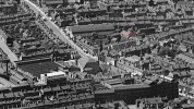
Lyn, here's a wider view with the ice rink in Summerhill on the left and Springhill running right from the library to possibly as far as Eyre Street. (left click the pic twice to enlarge and scroll around it)
Springhill__1933.jpg
image source 'britainfromabove'
 
Last edited:
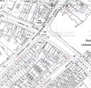
Thanks Old Mohawk, the maps show the area where the premises were located in the first stretch of Spring Hill starting at the corner with Monument Road. The house numbers start at this point so 1to 20 would be the first buildings along Spring Hill from the corner with Monument. I notice there is a block of premises and then a gap with a detached property. I have a feeling that the premises I am interested in is in that area.
 
Thanks Old Mohawk, the maps show the area where the premises were located in the first stretch of Spring Hill starting at the corner with Monument Road. The house numbers start at this point so 1to 20 would be the first buildings along Spring Hill from the corner with Monument. I notice there is a block of premises and then a gap with a detached property. I have a feeling that the premises I am interested in is in that area.
Hi Cranky
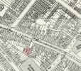
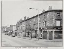
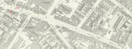
The map below dated 1914 shows a Methodist Church (shaded pink) with an opening to Springhill. Regarding the image in post#41 I've edited corresponding pink shading on the church and the opening appears to be fronted by a wall with an arched opening to the street. I can't seem to find a better 1930s map.
1914_SpringHillChurch.jpg
 
From British History Online. I assume this is the chapel marked on 1914 map

Spring Hill chapel was registered for public worship by the Primitive Methodists in 1909, and appears to have replaced Edward Street, It was closed in 1921 or 1922, many of the congregation migrating to New Spring Street chapel,
 
From the respective maps it looks as if the Methodist church had become a warehouse by 1950 so probably not the building I remember unless it changed use again. I can’t remember the precise year(s) I was aware of it but I lived in the area (St.Marks Street) from about 1948 to 1956 aged 8 to 16
 
I cant get my bearings on this photograph from 1933. My Mom Claire Baglin was born in Eyre street in 1933 and I wondered if it appeared on this photograph.
 
I cant get my bearings on this photograph from 1933. My Mom Claire Baglin was born in Eyre street in 1933 and I wondered if it appeared on this photograph.
I've edited in a tiny red dot into the post#44 pic at the junction of Eyre Street and Springhill. Follow Springhill from the Library (centre of pic) to the right edge of the view and you will see it. Left click pic and click again to enlarge then scroll across to the right. You could also save the pic in your own device and enlarge it.
 
Back
Top