• Welcome to this forum . We are a worldwide group with a common interest in Birmingham and its history. While here, please follow a few simple rules. We ask that you respect other members, thank those who have helped you and please keep your contributions on-topic with the thread.

    We do hope you enjoy your visit. BHF Admin Team

Lauren Morgan

New Member
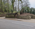
Walking along Harborne Road this morning (just after the junction of Augustus Road and Chad Road and where Harborne Road curves round to the right), I noticed a bit of wall which looks like it has an old fireplace embedded in it or similar. I haven't noticed it before as it's been covered in ivy. Having had a look at some old maps it looks like there used to be a Lodge on that site of a bigger Estate called 'South Bank'? It looks like it was there until the 50s or 60s as that's when other houses start appearing on that plot of land. I just wondered if anyone could tell me anything more about it? I'd love to identify how what appears to be a fireplace has ended up in the front wall of someone's property. I've posted the link to the NLS map comparison which shows roughly where it is now and what it looked like in the 1800s.


This is my first time posting on this forum so apologies if I've not posted it in the right place or have missed out some crucial information. Grateful for any assistance.
 
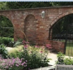
I can't see a chimney opening. I also think I have seen walled garden walls with arches like this. Will see if I can find a pic to show what I mean.
 
Strangely the name "South Bank" does not seem to appear on 1871 or 1881 census nor in drectories. The house also seems to change number.
 
Last edited:
Really interesting, thank you! I'll try to get a slightly better picture when I'm going past next week to see if that helps. Would love to see a picture of the type of garden walls you mean.
 
This is the best I can find. It has arches some of which are open and some filled. These are larger than the one you found - I thinl the size deends on the height of the wall.
1647621329402.png
 
Sorry - I know this is a reply to a relatively old thread, but I'm new to the Forum and I am very interested in "South Bank" in terms of its history (before, during and after the main mansion house). I'm only guessing, but I wonder if that 'fireplace' on the boundary wall is actually a 'nook' to hold a lantern - e.g. to show the coachman (coming back from the city) where the entrance to the Lodge/estate was when it was dark, given the street lighting in the mid to late 1800s was probably not the best. Just a thought. In terms of what I know about the South Bank estate, its most famous occupant was Abraham Follett Osler - he was renowned for glass and chandelier making (see other threads) but he was also a meteorologist, and he donated the bells and clock for the clock tower of the Arts Gallery/Council House. In terms of other occupants, in Kelly's Directory of 1835, John Yeend Bedford (solicitor and Justice of the Peace) was recorded as living at "South Bank, Harborne Road". I can't remember where I saw this, his daughter (Catherine Sarah Jenner Bedford) was apparently born in "South Bank, Edgbaston" in 1824. According to a Post Office Directory of 1854, there was a William Spencer (also a solicitor/attorney) living at "43 South Bank, Harborne Road" - John Yeend Bedford died in 1854 and I believe he had already moved to Abbey House in Pershore and had been there for some time. Obviously, its been found that Osler was in South Bank at least from 1868. I'm not sure whether John Yeend Bedford or William Spencer lived (or built) the South Bank mansion house or if this was replaced and built by Osler. The number for South Bank appears to be 43 'early on', but then by 1871 it was 86 Harborne Road, so there may have been a number change as property development and infill progressed along the city-centre side of Harborne Road (numbers start at Five Ways and move out from the city centre). I don't know much about what happened to South Bank after Osler died in 1903, but I have seen a photo from the 1920s/30s (no specific date) of a sign saying the estate was going to be built on with a number of houses - so it may be by that stage that the estate was chopped up for development, though whether the mansion house was demolished in the process, I'm not sure as yet. I know that there is a list of Botanical Garden members from 1938/39 on the internet somewhere showing that a William L Barber lived in "South Bank" but whether this is one of the newer developments or the original mansion house, I'm not sure. Hope this is useful. I'll keep looking! Thanks.
 
Walking along Harborne Road this morning (just after the junction of Augustus Road and Chad Road and where Harborne Road curves round to the right), I noticed a bit of wall which looks like it has an old fireplace embedded in it or similar. I haven't noticed it before as it's been covered in ivy. Having had a look at some old maps it looks like there used to be a Lodge on that site of a bigger Estate called 'South Bank'? It looks like it was there until the 50s or 60s as that's when other houses start appearing on that plot of land. I just wondered if anyone could tell me anything more about it? I'd love to identify how what appears to be a fireplace has ended up in the front wall of someone's property. I've posted the link to the NLS map comparison which shows roughly where it is now and what it looked like in the 1800s.


This is my first time posting on this forum so apologies if I've not posted it in the right place or have missed out some crucial information. Grateful for any assistance.
I actually think the fire place is what remains of the lodge to South bank Estate
 
hi janet i think its too close to the road to have belonged to the actual lodge but could be wrong...i was wondering if if it was a lodge keepers cottage which would have been built closer to the road...just a thought...

lyn
 
With regard to the estate generally, it is difficult to search for South Bank as there are several, in particular, and particularly around the 1950s the South Bank of the Thames, with the 1951 exhibition. However these two cuttings from 1937 and 1954 give a little information


Birm post, 20.11.1954.jpgBirm Gaz. 26.6.1937.jpg
 
Wow - that's really useful info mikejee - thanks so much for that. So the chances are that the mansion house was gone by 1937 then (unless it remained in that small strip of land, but I assume unlikely). On the "fireplace" - I agree that it seems too close to the road. I've managed to find an old map from Scotland National Archives - see attached for screenshot - the Lodge (or whatever building it is) seems to be a little back from the boundary wall with the road and I think that wall original. So the mystery remains.
 

Attachments

  • South Bank 1887 OS Map.png
    South Bank 1887 OS Map.png
    1.3 MB · Views: 20
hi kev if you look at the shape of the wall around the fireplace post 3 and compere it with the shape on your map certainly suggests that the fireplace belonged what could have been the lodge keepers cottage...

lyn
 
I'm not sure about that. If you hover your cursor over the cuttings it gives the date etc. The lower "Sales by auction " one is the 1937 one, and seems to say the house is still there then
 
I'm not sure about that. If you hover your cursor over the cuttings it gives the date etc. The lower "Sales by auction " one is the 1937 one, and seems to say the house is still there then
Ah - I see what you mean - so sometime between 1937 and 1954 it was potentially demolished. Ok.
 
hi kev if you look at the shape of the wall around the fireplace post 3 and compere it with the shape on your map certainly suggests that the fireplace belonged what could have been the lodge keepers cottage...

lyn
Hi Lyn. On the map, near post 3 there is some kind of double box rectangle shape - I can't work out what it is, as the map blurs when I zoom in - I don't suppose anyone knows what that is? Is it a 'map symbol' or some kind of construction or something? Seems very small. Unless it is the actual 'fireplace' arch we have been discussing.
 
Hi Lyn. On the map, near post 3 there is some kind of double box rectangle shape - I can't work out what it is, as the map blurs when I zoom in - I don't suppose anyone knows what that is? Is it a 'map symbol' or some kind of construction or something? Seems very small. Unless it is the actual 'fireplace' arch we have been discussing.
hi kev which map are you talking about...what post number is it on..

lyn
 
Hi Lyn. On the map, near post 3 there is some kind of double box rectangle shape - I can't work out what it is, as the map blurs when I zoom in - I don't suppose anyone knows what that is? Is it a 'map symbol' or some kind of construction or something? Seems very small. Unless it is the actual 'fireplace' arch we have been discussing.
right i can see that double box now kev..no idea what it denotes..have to admit that maps are not my best subject...hoping to get down there tomorrow to take a closer look at the chimney..

lyn
 
This map?. Not sure what you mean. Do you mean the area marked in red? The cross-hatching indicates a glass-roofed structure (probably greenhouse), In this case there is probably a main greenhouse, with a narrow greenhouse next to it

1887.jpg
 
yes that map mike ..if you look at the numbers bm5163 near to the pavement there is a little double rectangle below the number 3..think that is what kevin is referring to...i think lol

lyn
 
yes i guessed it was that one kev...dont think its anything to do with the lodge though because if you look around there are more marked on the map

lyn
 
I hate to be the bearer of bad news but...I don't think it is there any more. :( Could be covered I suppose.
See present streetview
 
yes i guessed it was that one kev...dont think its anything to do with the lodge though because if you look around there are more marked on the map

lyn
No - I think you're right - they look like drain covers as they are dotted around on the side of the roads. pjmburns - I looked on StreetView too and unless its covered by the ivy, I have a horrible feeling it might have been knocked down too. Could wait until winter(!)
 
Back
Top