Mike. So does the '2' alongside the 'MS' on here mean 2 miles from B'ham? If so would there have been two milestones with the same inscription? Viv.
-
Welcome to this forum . We are a worldwide group with a common interest in Birmingham and its history. While here, please follow a few simple rules. We ask that you respect other members, thank those who have helped you and please keep your contributions on-topic with the thread.
We do hope you enjoy your visit. BHF Admin Team
You are using an out of date browser. It may not display this or other websites correctly.
You should upgrade or use an alternative browser.
You should upgrade or use an alternative browser.
Soho Hill
- Thread starter Astoness
- Start date
Sorry. Forgot to post the section of the map I'm talking about. Here it is

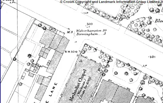
Your second map is interesting Mike. The milestone which was pictured outside Denbro's in the 1960s used to be on the other side of the road. Your map shows it to have once been about here, near the bus stop, just up from Soho Avenue :

These things seem to have moved about quite a bit! Viv.
These things seem to have moved about quite a bit! Viv.
The one on the right of the map says 2 miles to Birmingham does it not. I have no idea of the age of the stones, but the measurement used to be from the Market Cross in the Bull Ring. That stone also gives 111 miles to London I think.
So the one on the left of the road would be 2 miles to somewhere else. As Mike says, the Baggies ground is just 2 miles from it...so maybe 2 miles to West Brom. (maybe a market cross there at one time).
Perhaps the one outside the West Brom ground said 4 miles to Birmingham and was on the driving side of the road.
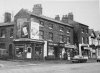
great pic phil nice to see the milestone in its originally place..actually i say that but the school is built on the ground where those shops were so it has not really moved much..maybe a few feet..here is a pic i took of it last week just inside the school grounds of holyhead school.

This milestone is not the same as the one in post #65.
hello rupert yes we know its not the same one...think we said a few posts back that the mileages on the two stones are different ...the stone on post 65 is the one that was at soho hill (and to date we dont know what happened to it i am making enquires) and the stone on post 102 is the one that was a mile further up the road on the corner of milestone lane and holyhead road..when they demolished the properties you can see in phils photo(you can see the stone inbetween the two shops) they built holyhead school on the ground and that is where this stone is now so its only moved a couple of feet as holyhead school is on the corner of holyhead road and milestone lane..
lyn
Last edited:
Ahh..ok. If you measure the distance from that spot to where the old 'market cross' used to be at the top of the bull ring, you will find that it is exactly (almost anyway) 2 miles. As the crow fly's. Did not try the 11 to Wolverhampton. The two on the map don't seem to be a mile apart.
most annoying rupert that we dont know what happened to the soho hill milestone..i have done quite a bit of on foot walking around the area to see if i can see it as my feeling is if it was moved again then it really should be close to its original spot..ive looked in king edward grammar school rose hill road grounds...st michaels church..tried to get into soho house but it was locked..i honestly think its either been removed and broken up by whoever took over dennisons factory where the stone was to make way for parking space..stolen and is in someones back garden or the the council have removed it and hopefully have it stored somewhere...my info is they date back to the 17th century...
lyn
lyn
Last edited:
The elusive Denbro building milestone near Soho Avenue apparently dates to when Thomas Telford improved the road in about 1824 (although the turnpike opened much earlier in 1727). The Telford changes I think changed the gradient of the road. Viv.
Stephen0002002
master brummie
Someone in the council must know where it is. I am sure I saw a milestone in the science museum a few years back (but thats a long shot). The Milestone Lane one (on the way up to the New Inns) was something I used to pass every day in the early 60's. It was on the inside edge of the pavement and it was then moved back as you say and eventually inside the fence of the school - which probably saved it.
Its another great thread this one and so nice to know we share the same fond memories and places as they were - thank you for the pics and all the foot work too. We will find the "temporarily" missing milestone - of that I am sure.
Its another great thread this one and so nice to know we share the same fond memories and places as they were - thank you for the pics and all the foot work too. We will find the "temporarily" missing milestone - of that I am sure.
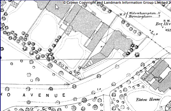
Just for info, the Soho Avenue milestone was still there in 1913 (put a little red dot on map below). There's an arrow showing it located on the edge of the pavement. Wonder why it moved across the road to Denbro's? I'd have thought it would have made sense to leave it on the Soho Av side. Maybe it was moved when the Denbro building was built? But seems a bit odd. Viv.
As usual forgot to attach map! Here it is. V.

Someone in the council must know where it is. I am sure I saw a milestone in the science museum a few years back (but thats a long shot). The Milestone Lane one (on the way up to the New Inns) was something I used to pass every day in the early 60's. It was on the inside edge of the pavement and it was then moved back as you say and eventually inside the fence of the school - which probably saved it.
Its another great thread this one and so nice to know we share the same fond memories and places as they were - thank you for the pics and all the foot work too. We will find the "temporarily" missing milestone - of that I am sure.
thanks for that great map viv..stephen i am a bit busy all this week but dont worry i shall leave no stone unturned to try and find this one..(sorry about the pun lol)
lyn
Hello Everyone,
First post here, but I have to say a I have ploughed through all the posts, and its a damned good read. I myself am an Aston Boy, Bevington Road to be accurate, however I have a question for you folks.
It concerns the parkland sandwiched between Claremont Road and Soho Hill/Hockley Flyover, and latterly known as Hockley Adventure Playground, for various reasons this has become of great interest to me, and whilst my primary concern is looking forward rather than backward, it's in my nature to try and understand the history, I have been and looked at Birmingham Planning and it would appear there has been a park here since the turn of the century and even further back, I have also found the ward minutes that lead to withdraw of support for the site because the Council thought that lack of funding would lead to children getting hurt atthe site in the late 1980's. Since then it has gone to seed, which is a terrible shame because it sits central to a huge community, and one that is quite tightly nit.
The good news is that if it's anything to do with me the site will continue to be used by the community, and that this summer will see the site being regenerated for that purpose.
Any help, information, pictures or stories would be greatly appreciated.
Last edited:


Jayell
master brummie
Oh Lyn - how upsetting those photos were. How many times did I walk up that road? More than I care to mention! OK, I am going back many years now but how sad it is to see how the area has deteriorated. There were some lovely houses on Soho Hill. I think I will just remember Handsworth as it was when I grew up there as I have fabulous memories. Thanks for posting them
Judy
Judy
Last edited:
Oh Lyn - how upsetting those photos were. How many times did I walk up that road? More than I care to mention! OK, I am going back many years now but how sad it is to see how the area has deteriorated. There were some lovely houses on Soho Hill I think I will just remember Handsworth as it was when I grew up there as I have fabulous memories. Thanks for posting them
Judy
hi judy and our memories are the one thing that cant be taken away from us...
Lyn
Great pictures, but in the second lot, aren't the 1st and third the same, with just a slightly different tint to them ?
error on my part mike just tried to delete the one but its gone back on underneath...think i best leave it lol


