-
Welcome to this forum . We are a worldwide group with a common interest in Birmingham and its history. While here, please follow a few simple rules. We ask that you respect other members, thank those who have helped you and please keep your contributions on-topic with the thread.
We do hope you enjoy your visit. BHF Admin Team
You are using an out of date browser. It may not display this or other websites correctly.
You should upgrade or use an alternative browser.
You should upgrade or use an alternative browser.
See Birmingham by Post Card
- Thread starter motorman-mike
- Start date
S
Stitcher
Guest
Judy39, some of the old buildings were truly magnificent werent they. What short sightedness to knock them down willy nilly. Can you imagine if the old city center was still there, pedestrianised and perhaps slightly modified in places with a decent ring road and ample access to car parking. I think more people would visit to see that, than come into town to see the Selfridge monstrosity.
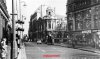
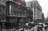
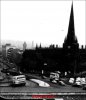
Colmore Row looking from The Town Hall in 1898 and 1971
Colmore Row looking from The Town Hall in 1898 and 1971
Attachments
Last edited by a moderator:
The old Christ Church was about to be knocked down in 1898. It was possibly abandoned when that photo was taken. None of us ever saw it of couse. There were shops around that corner for all of our years. This would be one of the buildings that I personally would not have missed. I think it's design was hideous and had become out of place in it's location. One of the best photo's of it on here.
The street lamps were beautiful though. I wonder if the older photo was taken by the same person who took the photo of the old Bridge Street coal wharf on the canal section. Maybe these old photo's were also taken as a last chance to record before demolition, similar to some later day ones on here.
The street lamps were beautiful though. I wonder if the older photo was taken by the same person who took the photo of the old Bridge Street coal wharf on the canal section. Maybe these old photo's were also taken as a last chance to record before demolition, similar to some later day ones on here.
S
Stitcher
Guest
Rupert and Ger22van, of course there were many bueatiful buildings in past times and unfortunately Bham City Council has never been top of the class for preservation or retoration.
S
Stitcher
Guest
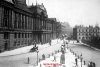
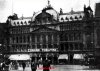
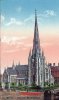
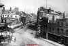
Stratford Road Camp Hill, King Edwards V1 Grammar School 1885. Did you know that this was the site of a one day skirmish with Prince Ruperts forces in 1643. It was built as a grammar School in 1883. In the second photo taken 1971, the school is visibly larger. This is because the giirls school was added in 1893. In 1956-58 the schools at Camp Hill moved to Vicarage Road Kings Heath. The building was then renamed and used as Bordesley Teachers Training College.
Attachments
Last edited by a moderator:
florence butler
master brummie
Just bought myself up to date with another browse on this thread.
Thanks yet again for the nostalgic photo's of dear old Brum.....Florence
Thanks yet again for the nostalgic photo's of dear old Brum.....Florence
S
Stitcher
Guest
Glad you enjoy them.
motorman-mike
Brum visitor who stayed.
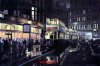
What a superbe shot. Rode those tramlines many times past Lewis's and out through Ashted Row. Wonderful to see the rolldown shades over the shop windows. Just back a bit would be Martineau Street on the right and Cherry Street on the left. This is the area of the old Crooked Lane that led down to the first Cadbury's factory and the old well by Dale End.
S
Stitcher
Guest
motorman-mike
Brum visitor who stayed.

S
Stitcher
Guest
Mike,
the only trams I remember riding on were on the Bristol road to the Lickys, but I do remember the rink in Walford road. Lovely pictures.
the only trams I remember riding on were on the Bristol road to the Lickys, but I do remember the rink in Walford road. Lovely pictures.
motorman-mike
Brum visitor who stayed.
What a superbe shot. Rode those tramlines many times past Lewis's and out through Ashted Row. Wonderful to see the rolldown shades over the shop windows. Just back a bit would be Martineau Street on the right and Cherry Street on the left. This is the area of the old Crooked Lane that led down to the first Cadbury's factory and the old well by Dale End.
Funny you should mention Martineau Street Rupert, I had this one lined up so here it is.
Attachments
Last edited by a moderator:

First sighting of the old lane in the flesh. Wonderfull. I believe that this was sort of part of Cherry Street and ran down presumably in a crooked fashion to Dale End by the Welch Cross and the old well. When Martineau Street was put in most of this dissapeared but there was still an elbow of it remaining and I think that this photo captures it. Simply great. I think that the 1890 survey map shows this. I am stunned, you have made my day.
Phil
Gone, but not forgotten.
Rupert
If you follow this link, you will see another photo of Crooked Lane that I posted, and towards the end of the thread a little information on Crooked Lane.
https://forum.birminghamhistory.co.uk/showthread.php?t=13672&highlight=crooked
You might find this interesting reading as well.
https://www.birmingham.gov.uk/Media/?MEDIA_ID=143718
Phil
Last edited:
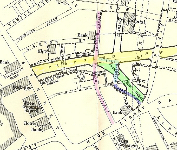
Here is the 1890 map ref. for those interested. You can hold down ctrl and use your wheel to zoom in. From the elbow of Crooked lane can be seen what looks like a passage way to the back door of a bank. I believe that there was a public well in this area; gone by 1890 but maybe this passage is where the pathway to it used to be. Brits seem to hold rights of way in tact for the most part.
https://www.british-history.ac.uk/m...=10098&ox=1992&oy=1375&zm=1&czm=1&x=282&y=161
It looks like Union Passage cut across Crooked Lane and ran to Bull Street at one time possibly.
https://www.british-history.ac.uk/m...=10098&ox=1992&oy=1375&zm=1&czm=1&x=282&y=161
It looks like Union Passage cut across Crooked Lane and ran to Bull Street at one time possibly.
Crooked lane is a little clearer on this earlier map dated 1875 Titled "Birmingham Improvement Scheme". The "Proposed new road " marked in yellow will eventually be Corporation St . The second new road (Martineau St) is in green. Cherry St -Union St is in red, Crooked lane is dark blue, and Little Cherry St is light blue. It can be seen that little cherry st changes to crooked lane at union passage
mike
mike
motorman-mike
Brum visitor who stayed.

Phil
Gone, but not forgotten.
Three different but nevertheless nostalgic views.
The first one is of a gas lamp cleaner / lighter in Lancaster Circus this was taken as late as 1968.
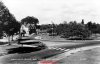
The next is Gas St Basin in 1952, before anyone ever thought of tarting it up, when a different type of citizen strolled the towpaths of the canal system.
The last one is the Horse Fair early last century. I thought Charlie Chaplin was in Hollywood by then.
Phil


.jpg")
The first one is of a gas lamp cleaner / lighter in Lancaster Circus this was taken as late as 1968.
The next is Gas St Basin in 1952, before anyone ever thought of tarting it up, when a different type of citizen strolled the towpaths of the canal system.
The last one is the Horse Fair early last century. I thought Charlie Chaplin was in Hollywood by then.
Phil
Last edited:
S
Stitcher
Guest
phil, nice pictures. I remember the gas lamp man doing the lamps in Oakhill Crescent when I was a child.
motorman-mike
Brum visitor who stayed.
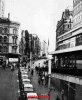
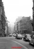
Meanwhile back in Corporation Street it's the mid 1970's. On the corner of New Street and Stephensons Place the Midland Bank has yet to be taken over by the Chinese HSBC and for Stitcher a queue of FX4 taxis' await fares on the rank.
Attachments
Last edited by a moderator:
S
Stitcher
Guest
I was looking for myself in the queue of cabs, then I remembered I only worked nights.
S
Stitcher
Guest
motorman-mike
Brum visitor who stayed.
Phil
Gone, but not forgotten.
Mike
We had a meal there boxing day 1977 (I think), when it was called the Blue Lamp. 24 of us I think, we were a mixed bunch, men, women and children. I paid the bill and the total for 3 course meals, bottles of wine and other assorted drinks for the evening came to a very reasonable £120. They didn't last that long in business, and to be honest at that rate I don't wonder.
Phil
S
Stitcher
Guest
The 1895 shot is the Birmingham of my childhood. Oh not with the horse drawn busses and the old church but if you just put 60s busses on there and some cars no one would notice much difference. We have seen similar shots before of this very place but they are always interesting in some way.