-
Welcome to this forum . We are a worldwide group with a common interest in Birmingham and its history. While here, please follow a few simple rules. We ask that you respect other members, thank those who have helped you and please keep your contributions on-topic with the thread.
We do hope you enjoy your visit. BHF Admin Team
You are using an out of date browser. It may not display this or other websites correctly.
You should upgrade or use an alternative browser.
You should upgrade or use an alternative browser.
See Birmingham by Post Card
- Thread starter motorman-mike
- Start date
Phil
Gone, but not forgotten.
Yes I agree that the Council House looks cleaner there than it actually was, lets face it even the colour of the stonework is different. The thing is if we look through the postcards on this thread, how many give a true image of how things really were, even the old ones have been retouched. I suppose the people who produced these postcards thought that no one would buy them if they showed dirty old dilapidated buildings so they gave them a little spring clean.
Lloyd
master brummie
The crossings did not have road markings until the mid 50s, just shiny metal squares in the tarmac. Belisha beacons were also not illuminated originally - just orange enamelled metal globes. Flashing beacons and rerd / black stripes were introduced to help motorists see the crossings in darkness, and although the origin of the name "Zebra Crossing" is disputed, it is generally attributed to British M.P. James Callaghan who, in 1948, visited the country's Transport Research Laboratory which was working on a new idea for safe pedestrian crossings. On being shown a black and white design, Callaghan is said to have remarked that it resembled a zebra.
sospiri
GONE BUT NOT FORGOTTEN
Lloyd & David,
I agree that the postcard looks very artificial and the building was very black with soot when I worked at BCT in the Council House extension from 1953 to 1958. But there was a massive building cleanup between 1958 and January 1961 (when I moved south to Dorset). I remember all the scaffolding going up and the sort of sand blaster and lots of water being used. I thought at the time that they would never get that clean, but it didn't come up too bad. Unfortunately they didn't do the Council House extension, which housed BCT and the Public Health Dept at that time.
So whilst I never remember it looking as bright and clean as your postcard, it definitely was cleaned in the late 1950s.
Maurice
paul stacey
master brummie
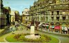
Great seeing that scene just as I remember it, but was't Joe Lyons corner house café, on that corner in the 50's? Paul
farmerdave
master brummie
Was there a bus stop outside J. Lyons in Victoria Square? The bus numbers 31A and 32, and I expect many others, did a town loop from top of Hill Street, then New Street, Corporation Street, Bull Street and Colmore Row before exiting New Street at Ethel Street and returning to either Acocks Green or Hall Green. Dave.
farmerdave
master brummie
Beat me by 3 minutes, Paul. Yes, Joe Lyons can be seen on the corner and I think it was there in the 50's and part of the 60's. DaveGreat seeing that scene just as I remember it, but was't Joe Lyons corner house café, on that corner in the 50's? Paul
DavidGrain
master brummie
That's right Rosie. I used to catch the No.7 Portland Road from that stop quite often, and I think the No.9 Quinton buses used to stop there are well, I seem to remember getting on one there at times, when I lived in Quinton.
I remember the no 9 as the first stop in Paradise Street, I am not saying that the 9 did not stop outside the Council House, I just remember catching it in Paradise Street. There were the BCT stops then the Midland Red stops. In the 1960s I used to walk up from Gosta Green after nightschool and it was usually touch and go whether I caught the 125/126 which had left the Bus Station in the Bull Ring at 9.30 or whether I had to wait for the 9.50. As I walked along that last stretch of Colmore Row I got to know which order the Midland Reds left the bus station as to whether I would catch my bus or not.
.jpg")
paul stacey
master brummie
#1722, My dear old Nannie would take me and my sister Marilyn there sometimes for tea and cake, lovely days gone for ever.paul
perry commoner
master brummie
I think that it was the late 1960s that all Corporation building were given a through clean of the stonework after decades of filth and grime from air pollution. The clean up was due to the new Clean Air act that has made life today so pleasant. Fortunately, we cannot see much of today air pollution.
brenda barr
master brummie
Just because we can'nt see pollution does not mean its not there....Brenda
Maria Magenta
master brummie
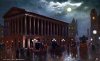
It looks very romantic!
Think it's one of the Tuck postcards. There are a few night time views in the range, I think the Town Hall one is especially lovely. You can imagine all those cabs returning people to their homes after an evening recital at the Town Hall. Viv
DavidGrain
master brummie
In the Town Hall post card, Any thoughts on what might be the tower in the distance just to the left of the Council House clock?
Phil
Gone, but not forgotten.
In the Town Hall post card, Any thoughts on what might be the tower in the distance just to the left of the Council House clock?
David
Given the angle of the view on the original postcard the only thing I could suggest would be the clock tower on what would be at that time the new White Horse Hotel. I certainly can't think what else you would see from that point looking down Congreve St toward Summer Row. It's either that or it's a bit of artistic licence
Attachments
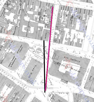
I think you are right Phil, and he has shifted the hotel tower a bit. Below is a map c 1889 showing the angle of site on the map. I reckon the building to the immediate right of the toen hall is the Liberal club, and the line of site would be the black line. The red line is to the White Horse hotel, and there is no gap between the club and the hotel, but there is a gap on the painting
Phil
Gone, but not forgotten.
Mike
What I thought was, as the original postcard would have dated from around the beginning of the 20th century that would be around the time that the White Horse Hotel was being built and the gap shown on the postcard was because the hotel and other adjacent buildings were incomplete. In fact the clock tower might have been standing on it's own at that time.
What I thought was, as the original postcard would have dated from around the beginning of the 20th century that would be around the time that the White Horse Hotel was being built and the gap shown on the postcard was because the hotel and other adjacent buildings were incomplete. In fact the clock tower might have been standing on it's own at that time.
DavidGrain
master brummie
Thankis Mike and Phil for your comments. I agree with your views that it is the White Horse but I think that there is artistic licence in that it is taller that in reality.
motorman-mike
Brum visitor who stayed.
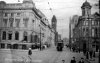
They can't match perfectly but for fun here are two Post Cards probably from the same photo shoot overlaid to give a Cinemascope view of Galloways Corner in the 1960's
Managed to find my original photo for this posting
Last edited by a moderator:
farmerdave
master brummie
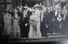
Picked-up this postcard today at an antiques fair in Woking. It is called "The Tea Party at Aston Hall" and looking on the internet it was held in honour of Joseph Chamberlain's 70th birthday. There is some writing on the bottom of the card that mentions Austen Chamberlain, Miss Dundas, and the Mayor and Mayoress of Birmingham. Dave.