pigsonthewing
knowlegable brummie
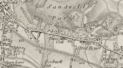
I am trying to find the location of the above. I have this press clipping, from Aris's Birmingham Gazette - Monday 12 October 1835 - p2 col 6 (transcription below):

Can anyone locate that on a map, please?
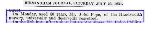
There is more about the Pope family at: https://en.wikipedia.org/wiki/Luke_Pope
Freehold Houses and Land, Handsworth, adjoining the Birmingham and Wolverhampton Road, at the Three Mile Oak Turnpike.
TO be SOLD by AUCTION, by E. and C. ROBINS, on Wednesday the 28th day of October instant, at four o'clock in the afternoon, at Radenhurst's New Royal Hotel, New-street. Birmingham, subject to conditions then to be produced-
Two Freehold Messuages fronting the Wolverhampton Road, in the parish of Handsworth, in the county of Stafford, nearly adjoining to the Three Mile Oak Turnpike House, in the occupations of James Upton and James Madders, with Gardens attached, together with two valuable pieces of Land behind the same, called Penny Field and the Croft, containing together two Acres and twenty Perches, now in the occupation of Messrs. Pope and Sons, as part of their Nursery Ground, under a Lease, of which 11 years were unexpired at Lady-day last.
For further particulars apply to Mr. H. M. Griffiths, Solicitor, Waterloo-street, or the Auctioneers, New-street, Birmingham.
Can anyone locate that on a map, please?
There is more about the Pope family at: https://en.wikipedia.org/wiki/Luke_Pope