-
Welcome to this forum . We are a worldwide group with a common interest in Birmingham and its history. While here, please follow a few simple rules. We ask that you respect other members, thank those who have helped you and please keep your contributions on-topic with the thread.
We do hope you enjoy your visit. BHF Admin Team
You are using an out of date browser. It may not display this or other websites correctly.
You should upgrade or use an alternative browser.
You should upgrade or use an alternative browser.
Photo Help Please
- Thread starter Lady Penelope
- Start date
Lady Penelope
master brummie
Thank you both. A great help.
Richard Dye
master brummie
Ah the insurance companies, don’t you love them! They’re only there when you do need them, but wait until you do!Lady P, I notice the sign has 23 on it. We had that on our road sign indicating Erdington, and the PO changed it to B6 and placed us in Witton.
Insurance for both cars and houses doubled and we then had a 5 year fight to restore us back.
Richard Dye
master brummie
SorryAh the insurance companies, don’t you love them! They’re only there when you do need them, but wait until you do!
NOT!
Richard Dye
master brummie
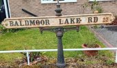
I thought exactly the same thing, how did the sign survive?Amazing that the old (maybe Victorian) road sign survived the new build houses and tarmacked pavement.
Lady Penelope
master brummie
Thank you photosym, everyone's been really helpful - as usual. I never expected to find an old sign and was thrilled when I saw it.
Talking about the sign itself - I am really puzzled as I thought this road was only named 'Baldmore Lake' when the Topcroft Estate was built in the 1960's. The whole of the estate was built on a site previously occupied by allotments and the only explanation I can think of is that this was the road that led from Goosemoor Lane. I will investigate further.
Pedrocut, the council have made several attempts to 'tidy up' our road into Erdington. I am an Erdington girl at heart but I know that we will suffer the same fate with insurance as you mention if this happens.
I recall there was a lot of research and discussion about Baldmore Lake on this thread.
There is also an unofficial website for Goosemoor Lane, Short Heath, Erdington, Birmingham, B23 here. This is a most facinating site, all done by a local guy.
There is also an unofficial website for Goosemoor Lane, Short Heath, Erdington, Birmingham, B23 here. This is a most facinating site, all done by a local guy.
Lady Penelope
master brummie
Pedrocut, the name Baldmore Lake appears on quite a few maps of the area and I think some of the land was where the lake was allowed to flood the land to act as fertiliser. It's been some time since I did the research so I will have to do some revising. I had a lot of support from the forum, as usual.
Morturn, I've been in touch with Gary on the Goosemoor Lane website and he is of the opinion that the sign dates from the 1930's but I only remember allotments so whether this was a road leading there or what I don't know. We used to go through the park to the garage on the far corner of Goosemoor Lane (once a farmhouse) to get paraffin for our 'Valour' stove.
I think maybe the red '23' could be a clue to the date as Erdington was only taken into Birmingham in the early 20thC. I wonder if any of our history buffs know when these numbers first appeared?
Thanks again for your input.
pjmburns
master brummie
bordesley bob
knowlegable brummie
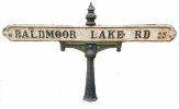
You could just crop it like this...Is there anyone who can suggest doing something with the background of this photo please? I need to use the road sign for a presentation and I'm doubtful about including someone's house in the picture. Any help gratefully received!
Thank you,
PennyView attachment 192851
Attachments
The Council had a few of those signes holders spare and did install one on our road quite recntly.Pedrocut, the name Baldmore Lake appears on quite a few maps of the area and I think some of the land was where the lake was allowed to flood the land to act as fertiliser. It's been some time since I did the research so I will have to do some revising. I had a lot of support from the forum, as usual.
Morturn, I've been in touch with Gary on the Goosemoor Lane website and he is of the opinion that the sign dates from the 1930's but I only remember allotments so whether this was a road leading there or what I don't know. We used to go through the park to the garage on the far corner of Goosemoor Lane (once a farmhouse) to get paraffin for our 'Valour' stove.
I think maybe the red '23' could be a clue to the date as Erdington was only taken into Birmingham in the early 20thC. I wonder if any of our history buffs know when these numbers first appeared?
Thanks again for your input.
They arestill making them, the modern ones now have a cast iron sign background and stick on letters.But I would have said the actual road name looks of an older vintage (cast iron) than the 1950s
Lady Penelope
master brummie
Thanks again to everyone for their input. I do feel that this is a fairly old sign but it may have been made just before the introduction of the B23 postcode area as it coincides with the building of this estate (late '60's early 70's) which is over half a century ago. Perhaps the modern signs just last longer!
Lady Penelope
master brummie
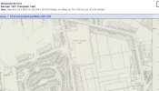
Janice, thanks for the map, it's a really good one as it shows the entrance to the allotments and the footpaths which crossed them. This whole are has now become the Topcroft Estate and where I took the photograph.


