• Welcome to this forum . We are a worldwide group with a common interest in Birmingham and its history. While here, please follow a few simple rules. We ask that you respect other members, thank those who have helped you and please keep your contributions on-topic with the thread.

    We do hope you enjoy your visit. BHF Admin Team

Perry Village

Viv
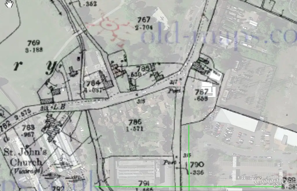
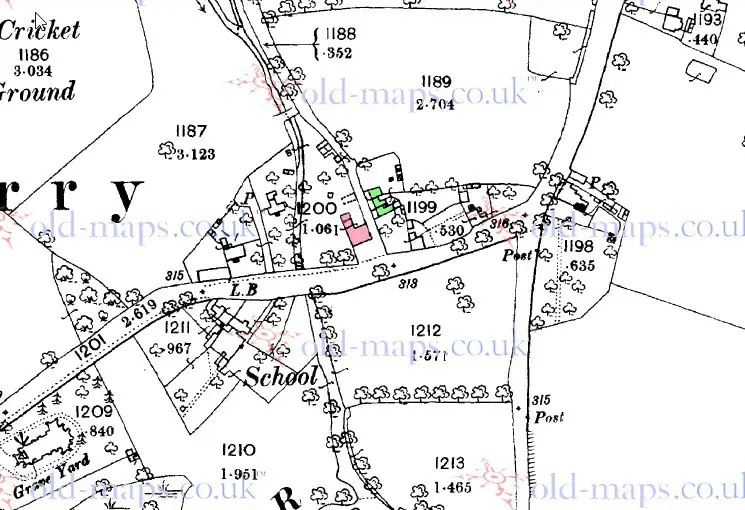
I would agree with your green dots. The 1890 map shows the same building as the 1904 one , marked in red. I have marked what I think are the cottages in green


map_c1890_showing_building_on_site_of_church_tavern.jpg


Thanks Mike for this. Very helpful. The School is clearly marked on it too. I notice the pathway or lane between the Tavern and the cottages was once an open thoroughfare, but seems to have in modern times been closed off. Possibly as a result of the expansion of the Tavern. Church Road once had a ford crossing but it's not shown on this map - I assume it would have been where the river runs under the roadway, just to the west of the Tavern.


I made a comment earlier about Ye Olde Oak Stores on the corner of Church and Aldridge Roads maybe being a post office, but it can't have been as I've just realised the building's not even on the map! Must have been built after the turn of the century. Also I'd always thought that the row of terraced cottages along Aldridge Road opposite Perry Park would have been built by the time of this map, but no, must have been built in the early 1900s.


Carolina - thanks for the photo of the Tavern. Looks well looked after, nice gardens etc. And I expect Perry Cottage was in either in Perry Village, Little Perry or Great Perry, Will have to do some research. Viv.
 
I think this might be Perry Cottage (below red dot on the 1904 map). Also a picture which shows the Cottage was alongside the river. Viv.
 

Attachments

  • image.jpg
    image.jpg
    192.3 KB · Views: 38
  • image.jpg
    image.jpg
    239.8 KB · Views: 32
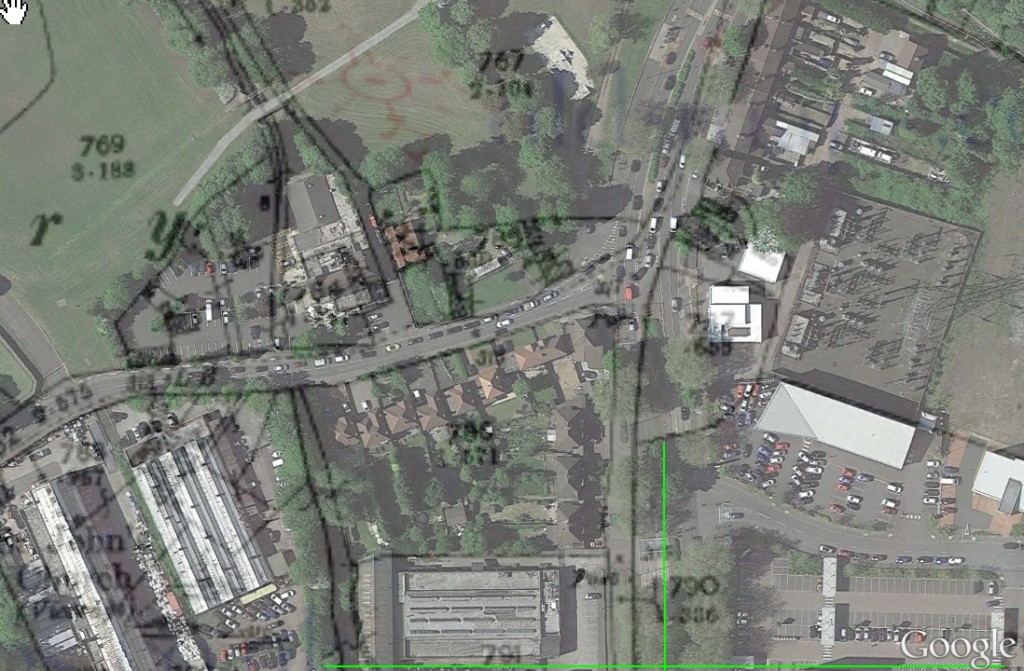
mike it is possible to have an overlay map please for vivs map post 32..would like to see what is now on the ground where the cottage was....

thanks mike

lyn
 
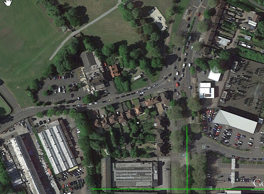
That's great Mike. So the cottage would have been at the edge of the Church Tavern car park, and in amongst those trees. I sense that the cottages to the right of the Tavern and Perry Cottage would have had some connection to the river at this point.

And re. St. John's Church and the School of Instruction, in an account entitled: "Consecration of a New Church at Perry Barr" of September 1833 it states "the attention bestowed by Mr and Mrs Gough, to the formation of the School of Instruction for the children of the poor Protestant population of Perry, doubly enhances the value of the munificent gift to the establishment" (The munificent gift being St. John the Evangelist Church, Perry Village. The Gough's generosity towards its tenants seems to have known no bounds).
Viv.
 
thanks mike yes viv thats the way i see it...perry cottage just behind the car park...i dont even know if that river is still there..would think not
 
Think the river's still there, Lyn, it goes under the road and, I guess under the Tavern car park. Did wonder if there's any evidence of Perry Cottage left in amongst those trees. Viv.
 
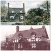
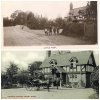
Perry Cottage can be seen to the left of this photo of the Church Tavern. How similar the two buildings were. Wonder if they were built as a pair of cottages. Perry Cottage looks older but could be wrong. Maybe the mock Tudor was added to the Church Tavern in the 1900s to make it look 'olde world'? I think there was a fashion for this style in the early 1900s. Viv.
 

Attachments

  • image.jpg
    image.jpg
    530.5 KB · Views: 25
Last edited:
Been studying the photos we have of the Church Tavern and a photo of "Little Perry" includes a view if the Church Tavern. In the "Little Perry" image, the cottage doesn't look like a tavern as such, no pub sign etc although that doesn't mean it wasn't some sort of beer house. And the cottage in the distance (middle) behind the children in the Little Perry image would have been in the centre of what is now the Church Tavern car park.

Also another photo of Perry Cottage. Viv.
 

Attachments

  • image.jpg
    image.jpg
    377.5 KB · Views: 34
  • image.jpg
    image.jpg
    36.9 KB · Views: 32
Last edited:
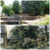
been down there today to take a few pics...this one shows the river (little footbridge to walk over) at the back of the church tavern which you can see if you zoom in and that is the last of it we see until it emerges again in church road opposite the large car park to the left of the pub as you look at it from the front (there is a smaller car park to the right of the pub)...the large pub car park is just behind the fence on the right in this pic
 

Attachments

  • PERRY VILLAGE 036.jpg
    PERRY VILLAGE 036.jpg
    779 KB · Views: 37
Last edited:
looking at the map on post 32 showing perry cottage as red dot it was set further back and to the left of both the pub and the 3 cottages that were at the side of the pub so my best guess is that perry cottage once stood roughly where the pole with the red top in this photo...
 

Attachments

  • PERRY VILLAGE 041.JPG
    PERRY VILLAGE 041.JPG
    929 KB · Views: 22
Last edited:
now for a few of the 3 cottages next to the pub (nos 15 to 19)..unfortunately there was a large van in my way moving stuff from the side door of the pub so i could not get full on shots..managed to get one of the back of them by squeezing hand and camera through the locked gates lol
 

Attachments

  • PERRY VILLAGE 045.JPG
    PERRY VILLAGE 045.JPG
    973.9 KB · Views: 27
  • PERRY VILLAGE 046.JPG
    PERRY VILLAGE 046.JPG
    748.8 KB · Views: 28
  • PERRY VILLAGE 047.JPG
    PERRY VILLAGE 047.JPG
    991.3 KB · Views: 26
  • PERRY VILLAGE 048.JPG
    PERRY VILLAGE 048.JPG
    912.2 KB · Views: 29
few more pic 3 note the cute little bench outside no 17...
 

Attachments

  • PERRY VILLAGE 049.JPG
    PERRY VILLAGE 049.JPG
    755.2 KB · Views: 24
  • PERRY VILLAGE 050.JPG
    PERRY VILLAGE 050.JPG
    623.2 KB · Views: 26
  • PERRY VILLAGE 051.JPG
    PERRY VILLAGE 051.JPG
    816.6 KB · Views: 27
  • PERRY VILLAGE 056.JPG
    PERRY VILLAGE 056.JPG
    1.3 MB · Views: 26
Great Lyn, thanks so much for your photos. I think an earlier version of the bridge is on the Perry Cottage image, albeit looking from the other direction. The old Perry Cottage image is looking away from the Church Tavern out towards Perry Park. I think the River must have been/is quite deep. In other photos of the River it looks like, at times, it becomes a very full river. Wondering if this has any connection to supplying the old Perry Hall moat? Viv.
 

Attachments

  • image.jpg
    image.jpg
    538.2 KB · Views: 31
  • image.jpg
    image.jpg
    36.9 KB · Views: 24
morning viv..no idea what P stands for or LB lol....im off out soon going to the birmingham lives history fair...back later with photos of st johns church but i think i will put them under its own thread...
 
Viv

Looking at the scene today, I would imagine that "P" stood for pathway although it is a gated concreted road now. I should think it was an access for carriages and a parking spot at the end where the occupants could alight for a stroll around the park.
 
Not much assistance, but according to Richard Oliver's ordnance survey book P. could be: Paling,parade,pass,passage, path, pavement,pillar,pinnock,place,plate,plug,pole,pond,pool,post,precinct,promenade,pump. or pylon. PA could also mean path.
As I said , not much use.
 
Spotted this watercolour for sale on eBay. It's dated 1880 and shows St John's, Perry Village and Christ Church spire (left). The painter is unknown but he/she must have painted this view from somewhere around Perry Park. Christ Church is now long gone, but it's described as the 'daughter church' on the St. John's Church website. Viv.

image.jpg
Watercolour of Perry Village 1880

image.jpg
Extract from St.John the Evangelist Church website

image.jpg
Christ Church at junction of Aldridge and Walsall Roads.
 
image.jpgimage.jpg

A view of the Church Tavern (sorry no date) and a modern Streetview for comparison. Much changed. I suspect (just a hunch) the Church Tavern has simply been added to over time and expect the original Tavern is still there underneath all those additions. The cottages on the roadside towards Aldridge Road have now gone. The odd thing sticking out of the cottage chimney (a weather vane ?) has appeared before on another thread and viewed from the other direction. Viv.
 
image.jpg

This map from a paper on the Mills of Perry Barr suggests there were a number of mills just north of Perry Village. I now beginning to think this must have been a good reason for the Village to be positioned where it is. The mills were Blade Mill, Upper Paper Mill and Lower Paper Mill (no dates). I now wonder if the bridge in Lyn's photo in post # 41 was connected with either Blade Mill or one of the Paper Mills. Having said that I've not yet seen any mills marked to the north on any maps. Maybe someone with local knowledge knows something about these Viv.
 
In a very old post about Perry Barr Park I mentioned the 'brook' as we called it but by the 1940s there were no traces of mills. There are some discussions in the Perry Mill thread. The parks department made a big effort in the park with significant brick water courses and a series of photos taken in 2005 of the brook flowing through these water courses were uploaded to the forum, although they looked rather run down from what I remembered as a child. I could put these photos which were lost from the forum in 2011 back into the Perry Barr Park thread just for the record, one of them shows the bridge behind the church tavern.
Click on links above to see the old information.

Thanks Phil. Going to go and have a look at those two threads, should be interesting. Viv.
 
Those two threads are very helpful Phil. Certainly seems there were mills north of the Church Tavern, including one Perry Village Mill (not to be confused with Perry Hall Mill to the south of Perry Village). Perry Village Mill looks likely to have been behind the Tavern in amongst the trees - the river/brook there has walls similar to canal walls, so they'd be pretty substantial. All very interesting stuff. I've extracted this out from the British History Online reference referred to in the Perry Mill thread. The mills seem to have disappeared after the 1860s

Viv.
 

Attachments

  • image.jpg
    image.jpg
    27 KB · Views: 22
Last edited:
I've spent a riveting afternoon pulling together the following summary of information about the Perry industrial mills in general and Perry Lower Mill in particular using the publication "Perry Barr and it's Water Mills" by P.W. King.


First, I've summarised this general snapshot of Perry industrial mills to give us context:


15th & 16th century - Perry Barr was rural, with a few industrial processes such as hammer mills
16th & 17th century - hammer mills here replaced by forges/blast furnacing, then these replaced by fulling (cloth processing) and paper mills
17th & 18th century - mills adapted from cutlery to blade and wire mills (decline in cutlery from Sheffield competition)
18th century - rise in sword cutlers for production of armaments
19th century - mills in use until mid-century until new sources of power found


Perry Lower Mill (blade mill/wire mill/paper mill)


Now I'll try to summarise the industrial activities which went on at Perry Lower Mill from the 1600s - 1860s.


Over several hundred years, the Mill went through a number of transformations, but it's notable that it was an early blade mill and, having been subsequently used for other purposes, it finally returns to use as a blade mill in the mid/late 1800s before it disappeared from the landscape.


1614 owned by a family of blade smiths
1670 owned by a cutler, but by now, a decayed blade mill
1685 leased by a short cutler
1722 converted to a wire mill, owners also owned Lower Paper Mill, the next mill north, which they
also converted to a wire mill
1727 a wire mill
1748 blocks, tongs, spindles, barrels, plates, hammers,gearing and tools transferred in a will to
descendant of owner
1819 mill let to a firm of platers of metal
1837 by now a paper mill let to a firm making button boards, japan boards, gun wadding, paper
mâché trays and paper manufacturing
1844 returns to a blade mill
1860s was probably deprived of its water supply in about 1860 when the mill was acquired by
Birmingham Water Works.


Now here's the crunch. King states in his work: "The site of the mill is now occupied by the Church Tavern, behind which there are obvious remains of a wheel pit on the edge of the park, where the brook passes into a tunnel under the inn. The dam for the mill pool survives as a low bank in the adjacent Perry Park".

So there we have it folks. If the author is correct, the Mill would be approximately located around where the Church Tavern now stands (or at least where the pre- enlarged Church Tavern building was built). That leaves us with a few 'bits and bobs' that might be worth following up such as:


Visual evidence of the mill pool low bank in Perry Park
Visual evidence of the remains of the wheel pit where the brook passes into the tunnel under the Tavern
Date of the cottages to the right of the Tavern - be interesting to know a bit more of their history
No longer there, but the date Perry Cottage was built to the left of the Tavern


Viv.
 
And a map from Kings "Perry Barr and it's Water Mills".
image.jpg
This is dated 1785 and is of Perry Lower Wire Mill. Viv.
 
excellent viv thank you...when i was down there the other week it certainly looked to me as though the brook/river ran more or less under the church tavern..it must then do a sharp right because if you cross over church road and stand with your back to the river it lines up with the pub car park...viv do i need to go down again??...please dont tell me i now have to go climbing into tunnels..not with my knees.. i thought my urban exploring days were over lol

lyn
 
Last edited:
Lyn, if you can manage to fit in a trip be nice to see anything along that tunnel and in the Park alongside the Tavern. Otherwise we could call in Time Team! In fact I think it's got the potential for a Time Team program; it's got former ironworks, its not far from the Ickniekd Way and Perry (Zig Zag) Bridge. So if you see any Samian ware Lyn, bring it back with you! Viv.
 
Last edited:
Back
Top