• Welcome to this forum . We are a worldwide group with a common interest in Birmingham and its history. While here, please follow a few simple rules. We ask that you respect other members, thank those who have helped you and please keep your contributions on-topic with the thread.

    We do hope you enjoy your visit. BHF Admin Team

Passages, Alleyways Gulletts and Snickets of Old Brum

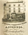
I think this advert for St George's Commercial Tavern shows the entrance to Corn Exchange Passage from High Street .... and maybe a view of the Corn Exchange building in the distance.
The 1849 Post Office Directory lists St George's coach office (shown on the left of the archway) at 45 High Street, adjacent to Corn Exchange Passage.

High Street (45) St George's Tavern (artwork) (Corn Exchange at rear) 1.jpg
 
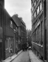
I'm having a problem locating this image of "Cole Holloway" Bartley Green as I can find no other reference to it. It's one of Sir Benjamin Stone's photos so obviously it dates before his death in 1914. I'm beginning to think it must be a forerunner of the Holloway that ran from Merritts Hill down to Merritts Brook Lane Northfield. I walked up and down there many a time with my brother in law for a drink at the Highlander pub at the top of the hill when my sister lived in Vinyard Road.

Can anybody confirm this or even refute the idea, because I really haven't a clue.

View attachment 124637

The picture posted by Phil (RIP) in post 1262 also appears in the Birmingham Archives and Collections; and is an example of being wary of dates quoted. The Archives give an unknown author but a date of 1937. Phil says the picture is one by Sir John Benjamin Stone and would therefore predate 1914 Although we cannot be certain it looks like Phil is right as the handwriting sure looks like that of Stone !
 
The route survives as a public footpath. Birmingham City Council’s rights-of-way note for the path “Cromwell to Woodcock” states the route was labelled “Cole Holloway” on a 1952 Quarter Sessions Highways Order and appears on the OS 6-inch (1880s) map; the order retained it as a public footpath.
 
Back
Top