-
Welcome to this forum . We are a worldwide group with a common interest in Birmingham and its history. While here, please follow a few simple rules. We ask that you respect other members, thank those who have helped you and please keep your contributions on-topic with the thread.
We do hope you enjoy your visit. BHF Admin Team
You are using an out of date browser. It may not display this or other websites correctly.
You should upgrade or use an alternative browser.
You should upgrade or use an alternative browser.
Passages, Alleyways Gulletts and Snickets of Old Brum
- Thread starter Dennis Williams
- Start date

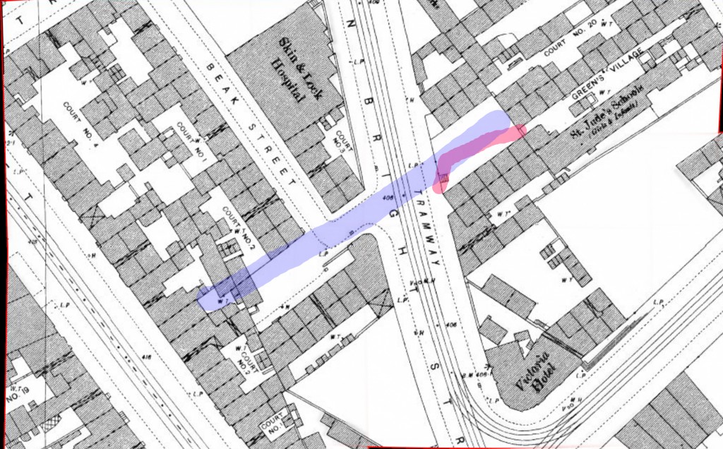
The exact extent of green's village is a bit obscure. It was finally demolished in may 1899, being the "Irish area", and rather notorious. The 1889 map below shows it, but here it is not connected to John Bright St (the wide street going down the middle), although it is on the photograph. we must assume that in earlier times it joined John Bright St with a kink (as in the photo), approximately as shown in red. The matter is complicated by the 1839 map, which shows a row of houses (approximately in the blue area ) marked Greens village, before John Bright St existed. so it looks as if, at one time, Green's village ran from Hill St almost to Suffolk St.
Mike
Mike
Dennis Williams
Gone but not forgotten
That's tremendous Mike, knew you would come through. In the 1861 Census there were 42 dwellings listed in Green's Village, and most of them were inhabitants from Ireland. The Census entry before No 1 Green's Village is 155 Hill Street (Tonks Street that was), so I guess you are right and Green's Village did join up with Hill Street, in 1861 at least. The Irish community were obviously well served by the St Jude's Schools, nicely shown in your map, and St Jude's Church, also nicely depicted and described in Jules' Thread link in my post No 192.
Thylacine
master brummie
A brief history of Union Passage, from:
Thomas T Harman. Showell's Dictionary of Birmingham. Birmingham: Cornish Brothers, [1885].
Thomas T Harman. Showell's Dictionary of Birmingham. Birmingham: Cornish Brothers, [1885].
Union Passage. — At first but a field path out of the yard of the Crown Tavern to the Cherry Orchard, afterwards a narrow entry as far as Crooked Lane, with a house only at each end, was opened up and widened in 1823 by Mr Jones, who built the Pantechnetheca. Near the Ball Street end was the Old Bear Yard, the premises of a dealer in dogs, rabbits, pigeons, and other pets, who kept a big brown bear, which was taken out whenever the Black Country boys wanted a bear-baiting. The game was put a stop to in 1835, but the "cage" was there in 1841, about which time the Passage became built up on both sides throughout.
Thylacine
master brummie
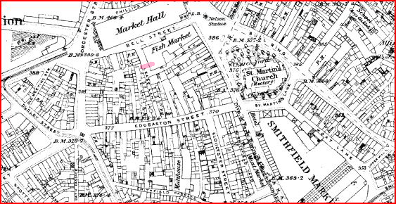
I can't find Lease Lane, the subject of this article, but the mysterious underground passage might just qualify for this thread. Can one of the threadmasters locate it?
Thomas T Harman. Showell's Dictionary of Birmingham. Birmingham: Cornish Brothers, [1885].
Thomas T Harman. Showell's Dictionary of Birmingham. Birmingham: Cornish Brothers, [1885].
Lease Lane. — Apparently a corruption of Lea or Leay Lane, an ancient bye-road running at the back of the Dog or Talbot Inn, the owners of which, some 300 years ago, were named Leays. When the Market Hall was built and sewers were laid round it, the workmen came upon what was at the time imagined to be an underground passage, leading from the Guildhall in New Street to the old Church of St Martin's. Local antiquarians at the time would appear to have been conspicuous by their absence, as the workmen were allowed to close the passage with rubbish without a proper examination being made of it. Quite lately, however, in digging out the soil for the extension of the Fish Market at a point on the line of Lease Lane, about 60 ft from Bell Street, the workmen, on reaching a depth of 8 ft or 9 ft, struck upon the same underground passage, but of which the original purpose was not very apparent. Cut in the soft, sandstone, and devoid of any lining, it ran almost at right angles to Lease Lane, and proved to extend half way under that thoroughfare, and some four or five yards into the excavated ground. Under Lease Lane it was blocked by rubbish, through which a sewer is believed to run, and therefore the exact ending of the passage in one direction cannot be traced; in the excavated ground it ended, on the site of a dismantled public-house, in a circular shaft, which may have been that of a well, or that of a cesspool. The passage, so far as it was traceable, was 24 ft long, 7 ft high, and 4½ ft wide. As to its use before it was severed by the sewerage of Lease Lane, the conjecture is that it afforded a secret means of communication between two houses separated above ground by that thoroughfare, but for what purpose must remain one of the perplexing puzzles of the past. That it had no connection with the Church or the Grammar School (the site of the old Guild House) is quite certain, as the course of the passage was in a different direction.
Thylacine
master brummie
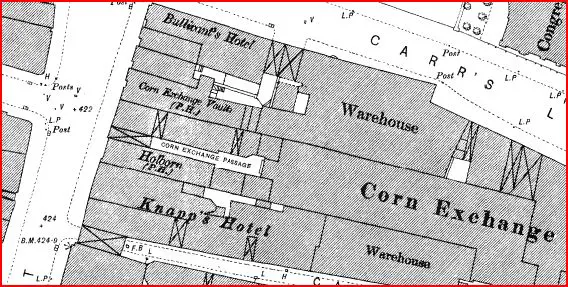
And where was Corn Exchange Passage, referred to in this extract?
Thomas T Harman. Showell's Dictionary of Birmingham. Birmingham: Cornish Brothers, [1885].
Thomas T Harman. Showell's Dictionary of Birmingham. Birmingham: Cornish Brothers, [1885].
Clubs. — ... A Club of more pretentious character, and called par excellence "The Working-man's Club," was begun July 20, 1863, but the industriously-inclined members thereof did not work together well, and allowed the affair to drop through. Backed by several would-be-thought friends of the working class, another "Working Men's Club" sprung into existence April 29, 1875, with a nominal capital of £2,500 in 10s. shares. Rooms were opened in Corn Exchange Passage on the 31st of May, and for a time all promised well. Unfortunately the half-sovereigns did not come in very fast, and the landlord, though he knew "Nap" to be a very favourite game, did not choose, to be caught napping, and therefore "took his rest" at the end of the fifth half-year, and in so doing rent the whole fabric of the club. ...
The first map shows Lease lane below. The tunnel seems to be to the back of the Fish market about where the red line is at right angles to the street. I would say that this was not likely to be connected to either the Guildhall or St Martins.
Corn exchange passage was off high St just below Carrs Lane, as shown on the second map
Mike
Corn exchange passage was off high St just below Carrs Lane, as shown on the second map
Mike

Dennis Williams
Gone but not forgotten
Lovely stuff boys, two more for Thyiie's Index....Cheers. And another from the same area. Smithfield Passage. I don't remember this at all. Looks a bit gloomy..


Last edited:
Dennis Williams
Gone but not forgotten
A brief history of Union Passage, from:
Thomas T Harman. Showell's Dictionary of Birmingham. Birmingham: Cornish Brothers, [1885].
Union Passage. — At first but a field path out of the yard of the Crown Tavern to the Cherry Orchard, afterwards a narrow entry as far as Crooked Lane, with a house only at each end, was opened up and widened in 1823 by Mr Jones, who built the Pantechnetheca. Near the Ball Street end was the Old Bear Yard, the premises of a dealer in dogs, rabbits, pigeons, and other pets, who kept a big brown bear, which was taken out whenever the Black Country boys wanted a bear-baiting. The game was put a stop to in 1835, but the "cage" was there in 1841, about which time the Passage became built up on both sides throughout.
Earned your stripes there old Devil. Terrific link, and here I was, just about to order this from Amazon...owe you a sherbert or two. "Well it's lonesome away..."
Dennis Williams
Gone but not forgotten
Sorry, forgot to post this Electoral Rolls entry to show inhabitants from Smithfield Passage in 1955. Also mentions another old favourite Scotland Passage, and another not mentioned on this Thread before Nelson Passage? Then what about Poultry (?), Sand Street, Slaney Street? No inhabitants. More research...onwards...

Last edited:
Have been very interested in this thread - I didn't know the area around New Inckleys was a 'bad' place - my grandfather was born in the area and my gt. uncle had a business in New Inckleys. And thank you Dennis for putting the Electoral list up - there were a family there that may be connected to mine (will put it on the right thread).
Thank you
Sheri
Thank you
Sheri
Phil
Gone, but not forgotten.
Dennis
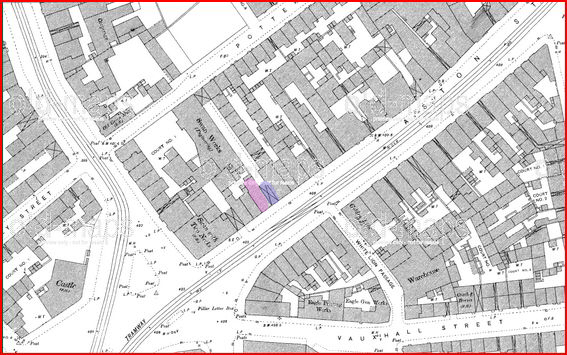
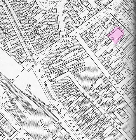
Slaney St ran from Snow Hill to Steelhouse Lane, It was an old narrow street and in latter years was mostly commercial, but I do believe there were houses there at one time. The only photo I have was taken on the morning of the 28th of October 1940 almost 70 years ago after a visit by some German lads. They seem to have left it in a bit of a mess. Perhaps it was a cup match.
Phil
Last edited:
Thylacine
master brummie
Another interesting snippet from SDB. Five Gullets! We've only found one or two: there's much more to discover yet!
Thomas T Harman. Showell's Dictionary of Birmingham. Birmingham: Cornish Brothers, [1885].
Thomas T Harman. Showell's Dictionary of Birmingham. Birmingham: Cornish Brothers, [1885].
Streets. — It is not every street that is a street in Birmingham, for, according to the Post Office Street List, besides a dozen or so to which distinctive names have been given, like Cheapside, Deritend, Digbeth, Highgate, Islington, etc, and 726 streets called Streets, there are in the borough 178 Roads, 86 Lanes, 69 Rows, 19 Squares, 11 Crescents, 2 Quadrants, 5 Arcades, 1 Colonnade, 5 Parades, 484 Terraces, 1,572 Places, 26 Passages, 20 Yards, 47 Courts (named, and twenty times that number numbered), 16 Mounts (twelve of them Pleasant), 24 Hills, 5 Vales, 2 Valleys, 23 Groves, 4 Retreats, 11 Villas, 14 Cottages, 2 Five-Dwelling, 179 Buildings, 14 Chambers, 12 Walks, 4 Drives, 3 Avenues, 5 Gullets, 1 Alley (and that is Needless), 1 Five-Ways, 1 Six-Ways, 6 Greens, 2 Banks, 2 Villages, 3 Heaths, 3 Ends, and 1 No Thoroughfare.
Thylacine
master brummie
A few more SDB snippets mentioning Birmingham passages (my bold green emphasis).
Thomas T Harman. Showell's Dictionary of Birmingham. Birmingham: Cornish Brothers, [1885].
Thomas T Harman. Showell's Dictionary of Birmingham. Birmingham: Cornish Brothers, [1885].
Banks and Bankers. — ... Lloyds' Banking Co (Limited) Colmore Row, dates from June 3rd, 1765. when it was known as Taylor and Lloyds, their first premises being in Dale End [hence the name of Bank Passage]. This old established firm has incorporated during its century of existence a score of other banks, and lately has been amalgamated with Barnetts, Hoares, and Co, of London, the present name being Lloyd, Barnett, Bosanquet, and Co (Limited). There are sub-offices also in Great Hampton Street, Deritend, Five Ways and Aston. In this and adjoining counties, Lloyds' number about 40 branch establishments. ...
Edgbaston Street. — One of the most ancient streets in the Borough, having been the original road from the parish church and the Manor-house of the Lords de Bermingham to their neighbours at Edgbaston. It was the first paved street of the town, and the chosen residence of the principal and most wealthy burgesses, a fact proved by its being known in King John's reign as "Egebaston Strete", the worde "strete" in those days meaning a paved way in cities or towns. This is further shown by the small plots into which the land was divided and the number of owners named from time to time in ancient deeds, the yearly rentals, even in Henry VIII's time being from 3 shillings to 5 shillings per year. At the back of the lower side of Edgbaston Street, were several tanneries, there being a stream of water running from the moat round the Parsonage-house to the Manor-house moat, the watercourse being now known as Dean Street and Smithfield Passage.
Hurst Street. — From Hurst Hill, once a wooded mount (the same being the derivation of Ravenhurst Street), was originally but a passage way, leading under an arch at the side of the White Swan in Smallbrook Street (now Day's establishment). Up the passage was a knacker's yard, a shop for the dyeing of felt hats, and a few cottages.
Restaurants. — Our grandfathers knew them not. They took their chop or steak at their inn or hotel, or visited the tripe houses. Indeed, Joe Allday's tripe shop in Union Street (opened about 1839-40) may be called the first "restaurant" established here, as it was the favourite resort of many Town Councillors and leading men of the town. A vegetarian restaurant was opened in Paradise Street in July, 1881, and 1883 saw the commencement of another novelty in the line, a fish restaurant in the old Warwick Passage.
Smallbrook Street. — A small stream, formerly ran its course along part of this site, proceeding by way of Smithfield Passage to the moat, and thence through the mill-pool, back of Bradford Street, to the Rea. The ancient family of the Smallbrokes held considerable lands in the neighbourhood, but whether the street's name came from the small brook or the Smallbrokes is a matter of doubt.
Temple Row. — A "parech meeting" in 1715 ordered the purchase of land for a passage way out of Bull Street to St Philip's Church. It was not until 1842 when part of the Royal Hotel stables were taken down, that it was made its present width. In 1837 the churchyard had some pleasant walks along the sides, bounded by a low wooden fence, and skirted with trees.
Trades and Manufactures. — ... Brass. — Brasshouse Passage, Broad Street, tells of the site of another smelting place, the last chimney of which was demolished on January 27, 1866. The Waterworks Co bought the site for offices.
Last edited:
Dennis Williams
Gone but not forgotten
You certainly know how to woo a Gulletguy Pierre. I am totally smitten by the wealth of interesting references to our quarry from Showell's Dictionary. Here's a couple mentioned above to add to the List. BRASSHOUSE PASSAGE and WARWICK PASSAGE. And thanks to Phil for finding a pic of the remains of Slaney Street. Reminds me of our first house...


Last edited:
Phil
Gone, but not forgotten.
Here an interesting one, the photo has been on here before but not in this context. It shows the entrance to Reeds Opening which I suppose could best be described as a dead end or shut. It was located on Aston St next to Cadwallers Bakery roughly I believe in the location of the now defunct Central Fire Station.
Phil

Phil
Last edited:
Dennis Williams
Gone but not forgotten
Not seen that one Phil. Superb shot. And never heard of Reeds Passage. Got a map Mike?
Dennis Williams
Gone but not forgotten
And whilst you are mapping where Reed's Passage is Mike, can you find a nice one for this photo of Anderton's Square which looks like it is straight out of Little Dorritt...or a posh version of a back to back Court yard...without the lavvies and mishkins.


Last edited:
Dennis Williams
Gone but not forgotten
Mike, you light up this thread with your maps, thanks so much. Now what about Gothic Arcade? I think Mossy published the picture I posted of this Alley on another earlier Thread, and if so I profusely apologise. And I think you were reticent about its name and location at that time? In any case, can you oblige for the record and to put me out of my misery pretty please once more?
Not reticent at all Dennis. I think you missed a post. Go to #53 at https://forum.birminghamhistory.co.uk/showthread.php?t=13578&p=343447 and there is a map.
Dennis Williams
Gone but not forgotten
I should cocoa Mike, the very thought. Don't know what got into me, half a bottle of a nice Vacqueyras shouldn't wonder....Sorry anyway. The map shows the Gothic Arcade AND Slaney Street. Double hit. Cheers again. I'm posting it again for posterity...hope you don't mind.

Last edited:
Dennis Williams
Gone but not forgotten
Something from Showell"s Dictionary of Birmingham. There are some hoary old favourites from this Thread on here to ponder...


Last edited:
Thylacine
master brummie
... Reeds Opening which I suppose could best be described as a ... shut ...
So it's an open and shut case then.
[Sorry, smileys forbidden on this thread. View attachment 58748]
Dennis Williams
Gone but not forgotten
Another one for the pot - Bristol Passage. Has it gone now?

Last edited: