-
Welcome to this forum . We are a worldwide group with a common interest in Birmingham and its history. While here, please follow a few simple rules. We ask that you respect other members, thank those who have helped you and please keep your contributions on-topic with the thread.
We do hope you enjoy your visit. BHF Admin Team
You are using an out of date browser. It may not display this or other websites correctly.
You should upgrade or use an alternative browser.
You should upgrade or use an alternative browser.
Passages, Alleyways Gulletts and Snickets of Old Brum
- Thread starter Dennis Williams
- Start date
Dennis Williams
Gone but not forgotten
Dennis
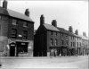
Could this be the entrance to your elusive passageway on Suffolk Street, which I actually think they built the College over.
This pic has to be taken before 1893 then Phil, when the Technical College was completed ...do yo think?
Phil
Gone, but not forgotten.
Dennis
It comes from Shoothill and though there is no date with it I would think it entirely possible that it dates pre the Birmingham Municipal Technical School. Though it was the two metal bollards that drew my attention to it as I could not think of any other place in Suffolk St that that may have been used.
It comes from Shoothill and though there is no date with it I would think it entirely possible that it dates pre the Birmingham Municipal Technical School. Though it was the two metal bollards that drew my attention to it as I could not think of any other place in Suffolk St that that may have been used.
Phil
Gone, but not forgotten.
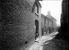
I'm inclined to agree with Mike that the photo's taken from under the bridge. Firstly the photographer was in pretty deep shade. The wall/building to the left has little sunlight on it nearest the photographer. And building and road to the right fit the angle of that building and the road direction on the map - see above the 'u' in 'U.K.' on map. Viv.
Had another look Phil. Think you're probably right. There are about 6 or 7 dwellings on the left which fit the map view from Park Street. Just at the end of the road as it bears off to the left in the photo you can see a building/wall which wouldn't be visible if you were looking from Park Street. The deep shade is probably accounted for by tall buildings blocking out the light.
Love exploring these photos. You just get a glimpse of a pulley (?) system at the top of the building where the children are sitting. They're sitting on a very wide sill too, so it must be industrial. Viv.
Love exploring these photos. You just get a glimpse of a pulley (?) system at the top of the building where the children are sitting. They're sitting on a very wide sill too, so it must be industrial. Viv.
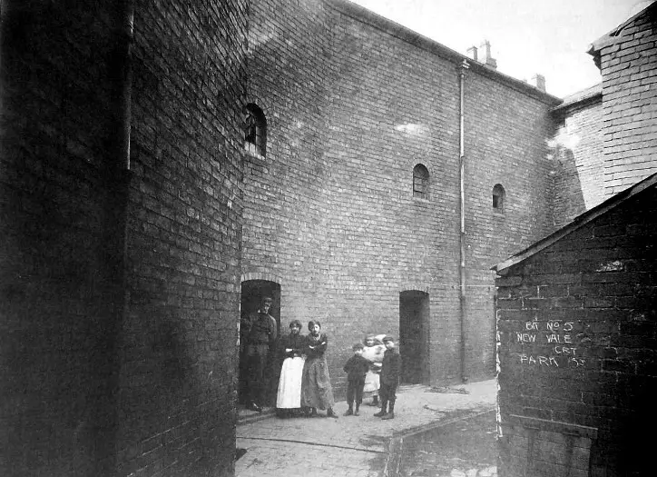
Actually i agree with Phil, though for a rather embarrassing reason. I saved the photo and then looked at the saved photo (I thought). Unfortunately i looked at the wrong photo . as i have another of the court. I attach it so you can see what I mean. This one is, I think from under the bridge.
Jayell
master brummie
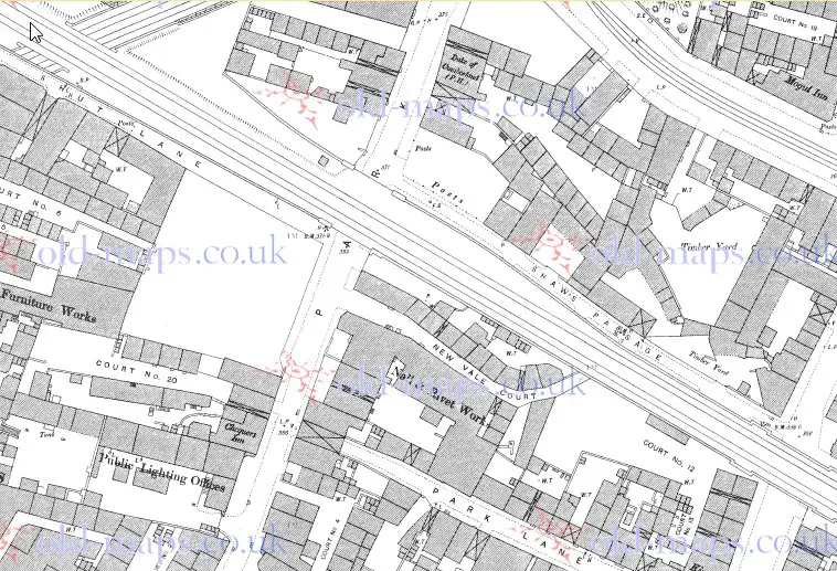
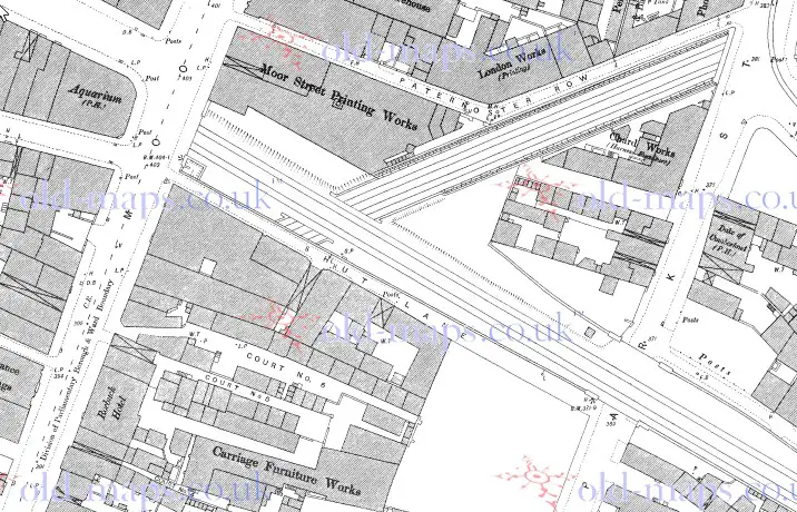
Good map showing New Vale Court, and I have no opinion as to where the photo could have been taken from - could even have been from the slight bend in the road! But I did like seeing Shut Lane on the map, Mike. Any chance of seeing a little bit further to the left of it? I've never seen it before and I do have connections with people living there in my family history. Would anyone have a photo of Shut Lane at all?
Judy
Judy
Hi Judy. Here's a photo, afraid it's not too clear but will give you an idea. It calls it a 'footpath' in the description.
https://www.geograph.org.uk/photo/1628760
And another one which is on the forum somewhere. Very narrow at this point.

Viv.
https://www.geograph.org.uk/photo/1628760
And another one which is on the forum somewhere. Very narrow at this point.
Viv.
Jayell
master brummie
Thanks a lot Viv. It all helps to form a picture. I did find another one on Flickr - which again shows it as a narrow cobbled lane. Long gone now. Judy
https://www.flickr.com/photos/geoffsimages/6474154547
https://www.flickr.com/photos/geoffsimages/6474154547

paul stacey
master brummie
#1189, what a fantastic atmospheric photo, the old Birmingham I loved, thanks for posting.Paul
Dennis Williams
Gone but not forgotten
Great new pic Speedwing....wonder what the Lane was like in 1785...before the railway line etc....?

DavidGrain
master brummie
I think I must have walked down Shut Lane at some time in my youth exploring the railway stations of Birmingham. The Snow Hill line on the left where you see a steam train. Moor Street Station on the right. Now all part of the extended station to take in the platforms on .the Snow Hill lines.
cracking photo speedwing.....is that a steam train i can see heading towards??
lyn
Yes Lyn, according to the caption a Hall class
For those with a memory the building on the immediate right of Shaw's Passage was the Moor Street Warehouse where as a toddler I would spend a happy hour stood on a stool peeking out an upstairs back window looking down on the trains heading for and emerging from the Snow Hill tunnel whilst my mum would buy haberdashery type stuff. Circa 1947-9

Another of Colin Walker's views of Shut Lane running alongside the Warehouse and the Snow Hill line

Clipped from an old GWR station plan Circa 1918
The Passage was still extant up until about fifteen years ago when it was swallowed up by the pedestrian access to the Snow Hill line platforms and the glass box adjacent to the original Station frontage.
There was a plan during Chiltern's station modernisation to move the old early 20th C Goods office frontage from the Selfridge's side of the site and re-erect it on the Warehouse site so as to visually "balance" the frontage. The plans indicated it as a wine bar.
The plan was scuppered due to concerns about overloading the tunnel crown beneath thus today's lightweight glass box of no real purpose.
Hi all.
I remember working on Moor Street Warehouse from about 1956 to the early 1960s and then the huge horses that used to pull the railway delivery carts would travel up Shut Lane morning and evening with showers of sparks off their hoofs as they tried to get a grip on the wet cobble stones that went from top to bottom, when working off scaffolds in the lane the old type steam trains used to cover us in black smoke and leave us coughing and spluttering, you can get an idea of the set up from photo 1195.
Regards Acklam 19.

Those insurance maps are great Mike. Lots of little details such as the urinal at the bottom of Shut Lane and 'Brick Wall' running alongside the Lane. I notice the use of different abbreviations such as LMTD for Limited instead of the usual Ltd. and ASSCE for what I assume is Assurance. Wonder what "None" means? No access maybe, or no water or non-flammable, given it's an insurance map. Viv
Viv
There is a summary of some of the terms at https://www.bl.uk/onlinegallery/onlineex/firemaps/england/northwest/goadlegendmanchester.html, but it does not include "None" so I agree the best guess is no doors or windows
There is a summary of some of the terms at https://www.bl.uk/onlinegallery/onlineex/firemaps/england/northwest/goadlegendmanchester.html, but it does not include "None" so I agree the best guess is no doors or windows
Thanks Mike. A great resource of maps too. Viv.