-
Welcome to this forum . We are a worldwide group with a common interest in Birmingham and its history. While here, please follow a few simple rules. We ask that you respect other members, thank those who have helped you and please keep your contributions on-topic with the thread.
We do hope you enjoy your visit. BHF Admin Team
You are using an out of date browser. It may not display this or other websites correctly.
You should upgrade or use an alternative browser.
You should upgrade or use an alternative browser.
Passages, Alleyways Gulletts and Snickets of Old Brum
- Thread starter Dennis Williams
- Start date

.JPG")
Phil
Gone, but not forgotten.
Terry
I have just clocked that your photo is of Eden Place, I thought it was another one of Coleridge Passage. No wonder my Solicitors office isn't there.
I remember Eden Place well, I remember the old pavement artist who always sat at the Edmund Street end of the Alley. I believe he was only begger in Birmingham who had a licence to beg on the streets.
Phil
Last edited:
terryb18
Gone but not forgotten R.I.P.
Terry
I remember Eden Place well, I remember the old pavement artist who always sat at the Edmund Street end of the Alley. I believe he was only begger in Birmingham who had a licence to beg on the streets.
Phil
I remember that artist too, I thought he did some brilliant pictures. Pity they was washed away.
Terry
The strip theory is very possible and streams and also mill races were used as landmarks to define ownership. Some of the roads west of the old manor house were guided by streams and brooks and leats...coming up diagonally from the Rea and the fields would surely have followed suit.
In Quebec when a farmer died his farm was divided up between the family and this resulted in long thin fieslds over time. This phenomena is apparent on the south shore of the St Lawrence with long narrow fields stretching for quite a distance down to the river.
GE... (Sainte-Croix Quebec Canada) and pan around the area. Was by there with the trailer this summer.
Frothblower
Lubrication In Moderation
Burlington Passage 1960
Dennis Williams
Gone but not forgotten
Here's one that always intrigued me. Was it ever inhabited or just the tradesmens' entrances? Waterloo Passage.


Last edited:
Phil
Gone, but not forgotten.
Dennis
There were quite a few of these service alley's around that area of the city. I used quite a few of them myself when doing internal alterations to some of the shops and offices. New Street used to be quite a warren of back alley's at one time, but there again so was Waterloo St & Newhall St.
This photo shows Old Meeting St, that ran from Dudley St to Station St and was the location of the Old Meeting House. To be quite honest I don't know if the street remains today, it's been that long since I have been into Birmingham.
Phil
Last edited:
Thylacine
master brummie
The Old Meeting House has a rather exciting history: first built in 1689 in Phillip Street (as Old Meeting Street was then known), it was burnt down in the "Sacheverell Riots" on 17 July 1715. It was rebuilt on the same site, only to be destroyed almost exactly 76 years later in the "Priestley Riots" on 14 July 1791. It was rebuilt by 1794 (as seen below), and lasted until 1885 when a new Meeting House was built in Bristol Street, the Old Meeting Street site becoming part of the New Street Station development.
[I hope I've got these facts straight. There's quite a lot about this subject, both on this Forum and in wider cyberspace.]
[I hope I've got these facts straight. There's quite a lot about this subject, both on this Forum and in wider cyberspace.]
Last edited:
Dennis Williams
Gone but not forgotten
The Old Meeting House has a rather exciting history: first built in 1689 in Phillip Street (as Old Meeting Street was then known), it was burnt down in the "Sacheverell Riots" on 17 July 1715. It was rebuilt on the same site, only to be destroyed almost exactly 76 years later in the "Priestly Riots" on 14 July 1791. It was rebuilt by 1794 (as seen below), and lasted until 1885 when a new Meeting House was built in Bristol Street, the Old Meeting Street site becoming part of the New Street Station development.
[I hope I've got these facts straight. There's quite a lot about this subject, both on this Forum and in wider cyberspace.]
Good Stuff again. Lots of juicy history facts. Loved New Meeting Street. Don't know why. Oh yes I do - it housed a great pub at it's apex, and just tucked down a bit, the old Expresso Coffee Bar, who's name escapes me for the moment but is on this Site I'll bet, where I wasted many a shilling trying to look sophisticated without mandatory duffle coat, and attract ladies. No. I didn't. Obviously wrong trousers too Gromit...
Attachments
Last edited:


Dennis Williams
Gone but not forgotten
Brilliant Phil. Actually, I always thought they were one and the same. You know, just a name change? I would love to know what happened to the Red Lion if not. I was just looking out Red Lion pics when you posted, I know I've seen a good one on the cover of Joseph McKenna's Central Bham Pubs book I loot mercilessly. Fire away...
The coffee Bar I mentioned in post 98 was La Fiesta I believe?
The coffee Bar I mentioned in post 98 was La Fiesta I believe?
.jpg")
Dennis Williams
Gone but not forgotten
That's the one. It looks perzackely on the same spot, so I presumed a name change. JMcK wrote that it was originally an old house built in 1780. The Victorian rebuild was given as 1899 when it was still listed as the Red Lion. I have no idea when or if it became the Waverley Hotel, but it looks the same building to me from the two photos you supplied?
Listings for New Meeting St
1956 10 & 11 Waverley Commercial Hotel
1962 10/11Waveriey Hotel, New Meeting st 4. Midland 0634
Listing for High St 1956:
1956 10 & 11 Waverley Commercial Hotel
1962 10/11Waveriey Hotel, New Meeting st 4. Midland 0634
Listing for High St 1956:
58 Red Lion P.H
.....
here are Albert & New Meeting streets, Dale end & Bull & Martineau streets
So they were different
mike
So they were different
mike
dek carr
gone but not forgotten
This for me was the most frightening St I ever walked down at night it only had 3 gas lamps along it, one in the middle and one at each end.there were never any building ever built on it On the one side was a 50ft blue brick railway escarpment on the other a 15 ft wall with Scamell trucks parked behind it there were hidden figures at the back of ever shadow and i had to be in the most bravest of moods to go down it. can anyone guess what it was called. Dek
Phil
Gone, but not forgotten.
As pointed out by Dek, not all the Alleys and passages were in the city centre. In fact there were hundreds more scattered around the town.
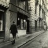
This one Regent Row is still around today in the Jewellery Quarter and was once a hive of industry. It runs from Warstone Lane to Regent Place. It doesn't look a great deal different today than it did a 100 years ago.
Phil


This one Regent Row is still around today in the Jewellery Quarter and was once a hive of industry. It runs from Warstone Lane to Regent Place. It doesn't look a great deal different today than it did a 100 years ago.
Phil
Last edited:
W
Wendy
Guest
Excllent photo's Phil now and then as you say not very different!
Phil
Gone, but not forgotten.
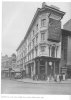
Another photo taken somewhat later than the previous posts original. Camden Drive that runs from Legge Lane to Camden Street situated in Hockley or is it Brookfields.
The corner building is still standing today, but like so many other commercial buildings in Birmingham it is now surplus to requirements.
Phil

The corner building is still standing today, but like so many other commercial buildings in Birmingham it is now surplus to requirements.
Phil
Last edited:
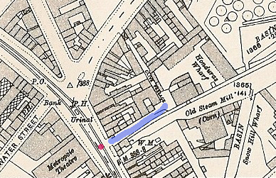
I took this picture yesterday,i haven't seen it mentioned on this thread before, nor is it shown on my A to Z.
I do believe it led to Birmingham's first fire station,as i think i have seen it on an old map in the past.Should have put it on The Where is this thread.
Moss.View attachment 57844
I do believe it led to Birmingham's first fire station,as i think i have seen it on an old map in the past.Should have put it on The Where is this thread.
Moss.View attachment 57844
Dennis Williams
Gone but not forgotten
I think I bought some fag cards from one of those tiny shops there many moons ago Aidan...still have them on my wall - Kings and Queens of England..
This is one I can't remember either. Clive Passage.


This is one I can't remember either. Clive Passage.
Last edited:
Dennis Williams
Gone but not forgotten
Brilliant Mike. I think I know the rough location now.
Now this is debatable whether it is strictly onside, but anyway. Phil's photo of Union Street showing the classic Evans shopfront and Alberta's hat shop (included again, thanks Phil) must have disturbed a neurone and I found another picture of the same area filed under Martineau Street (I know it wasn't a Passage), and this one shows the end of Evans's and indeed nearly the end of Martineau St in its entirety. In the Tram shot you can still make out the Red Lion on the corner of High St, and Alberta's titfer shop. The highlighted text is also interesting as it mentions stuff on Crooked Lane. From one of David Harvey's books on 'City Centre Past & Present'.


Now this is debatable whether it is strictly onside, but anyway. Phil's photo of Union Street showing the classic Evans shopfront and Alberta's hat shop (included again, thanks Phil) must have disturbed a neurone and I found another picture of the same area filed under Martineau Street (I know it wasn't a Passage), and this one shows the end of Evans's and indeed nearly the end of Martineau St in its entirety. In the Tram shot you can still make out the Red Lion on the corner of High St, and Alberta's titfer shop. The highlighted text is also interesting as it mentions stuff on Crooked Lane. From one of David Harvey's books on 'City Centre Past & Present'.
Last edited:
With ref to Clive Passage,here is a picture taken from the Summer Lane entrance.Moss.View attachment 57863