• Welcome to this forum . We are a worldwide group with a common interest in Birmingham and its history. While here, please follow a few simple rules. We ask that you respect other members, thank those who have helped you and please keep your contributions on-topic with the thread.

    We do hope you enjoy your visit. BHF Admin Team

Old street pics..

Dave,

Lacey's dental practice was a name from the past - all my mother's family went there in the 1940s & 50s.

Maurice
For me, it had great significance, not to muddy the thread but our mom's life changed so much after her ordeal, and not in a positive way.
Dave A
 
John,

If I remember correctly they were pictures of family at 2/15 Bartons Bank, not of Bartons Bank itself. I remember that right opposite the entrance to those back houses there was a coal merchant on the other side of the road. It will be later tomorrow before I can have a look.

Maurice
John, wasn't there a Bartons Bank on the corner of Milton St and Newtown Row?
Dave A
 
Hi Dave, just had a look at some old maps but the only Bartons Bank I can see is the one running off Potters Hill, I wish we had some pictures of it, it would be good to see the houses my mum's grandfather lived in.

John L
 
upper thomas st dated 1968..think i had a rellie here must check my papers..

View attachment 117404
Can'nt picture this house or shop...I lived opposite the school..the only sweet shop was run by the Rogers family opposite the junior section.....this house in between...Tower Road and Sutton street.?....the only other shop was my aunties...opposite the Seniors entrance. we lived next door and my family had done since 1900.+
 
Can'nt picture this house or shop...I lived opposite the school..the only sweet shop was run by the Rogers family opposite the junior section.....this house in between...Tower Road and Sutton street.?....the only other shop was my aunties...opposite the Seniors entrance. we lived next door and my family had done since 1900.+
Hi, What a nostalgic photo, I think this was 44 Upper Thomas Street, in 1943 it was being sold as a corner retail shop and dwelling house. John
 
Well My House is going to remain very dusty over the next few day's,These photo's are absolutely wonderful....I'm totally in awe with them...Can't stop going through all of them,they really are amazing..Thank you so much for these Postings.,,,
 
Hi Ray, thanks for your rewarding comments, I'm by no means a competent programmer but by the power of google I was able to modify some HTML code that I found. Basically you need MS notepad (or similar) for the HTML code, a decent scan of the map (JPG), Paintshop Pro (or similar) to put the little blue spots on the map, the images of course and a lot of spare time.

It took me about 4 full days to complete but I kept finding more and more images that deserved to be included. If you wanted to have a go I could talk you through it, would probably be best to send a personal message with your email rather than have us cluttering the forum. Thanks again, John
 
Two similar pics from the Newtown/Lozells area ....
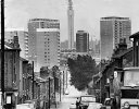
A view down Lennox Street. Construction of the P.O. tower in the pic was completed in 1965 so the date of the pic could be after then and maybe into the early 1970s. The tall 15 storey tower block on the left is Martineau Tower and the tall tower on the right is Scholefield Tower with the smaller 11 storey Bowater House tower seen between them.
Pic 1.
Lennox.jpg
A view down Anglesey Street. The tower block on the left is Rea Tower with Teviot Tower on the right. The houses on the left can be seen today. The Mini car reg suffix 'L' was issued in 1972.
Pic 2.
AngleseyStreet.jpg
 
Last edited:
OlMowhawk."
If you click on the first of these two and save it saves as "Newtown_-_Lennox_Street_-_Gerrard_Streetzt_23-7-1968" So presumably this is the date of the photo
 
Hi Mike,
I have often found that image dates on the internet can be wrong but the first image is from the Lennox Street thread and 1968 looks about right. The second pic can be seen in other places on the internet tagged as Lennox St but the P.O. tower should always be in view so I knew it was not Lennox Street. It took some searching to finally decide that it was Angesley St and only confirmed by studying lintels above house windows !
 
Sutton Parade late 1960s and a zebra crossing in need of a repaint but nice and handy for that Woolworths store.
SuttonWoolies.jpg
 
oldMohawks Lennox St photo #5,267 from yesterday. The shop on the left looks like the fish and chip shop I knew in early 1960s on the corner of Clifford St. Always called it "the crinklies" because their chips were crinkled. Wonder if anyone can verify that I'm not losing my memory.
 
Banjo

From the 1965 edition of Kelly's Trade Directory. 128 Lennox Street (corner of Clifford Street) The Welcome Fried Fish Dealer.
 
hi susan yes i like the wheeler st pic as well...we dont get many photos of the backs of houses..

thanks john..yes W H PRICE have come along way since those days...as you know i worked for them in the early 70s down summer lane....

lyn

Just saw this Lyn , you must have known a chap named Phil small frail looking chap , he worked on the trade counter I think . He used to be a DJ at weekends he played a couple of times in The Shareholders , I fixed one of his disco lamps , for which he was very grateful
 
this is the one i was talking about....just a solitary figure walking down an entry maybe coming home from the pub..looks like a ciggie box thrown on the floor..cant explain why this one fascinates me either...

entry leading to granville st...ladywood..

View attachment 117612

Lyn another one I've just noticed , I used to play with a mate who lived in the first house once you got passed the loo which is the building with the slight roof overhang. Right at the far end was where we used to have the annual bonfire . I think Carl Chinn some years ago done a feature on this yard as it contravened fire regulations
 
its great to see this thread picking up now..thanks to everyone for posting their old street pics...

residents of granville st (off broad st) after a campain to get them re housed has proved successful..oct 1965


View attachment 117613

rear of st martins st ...edgbaston dated 1965

View attachment 117614

birchfield road...perry barr dated..1967

View attachment 117615

Lyn I don''t know whether you are aware the people in the Granville St pic above are the residents ath the top of that entry in pic 423 my mates Mother is the woman in the black and white coat, there are a couple of women that lived in Granville St and never lived up that entry . I suppose they just got in the pic to make the numbers up
 
Just come across the interactive map, a fabulous resource, takes me right back for the first time in 70+years, thank you.
 
Banjo

A better photo of the corner of Clifford Street and Lennox Street for you c1968.

Lozells Lennox Street 1968[1].jpg
 
Banjo

A better photo of the corner of Clifford Street and Lennox Street for you c1968.

View attachment 129220
Thanks Phil, can actually see the "welcome" sign over the door now. Don't ever remember that though, we just called it the "crinklies". P.S had to smile about that snow on my head. Reminds me of the time when one had to be wary of the snow sliding off those steep inclined roofs of those old houses.
 
Last edited:
Used to throw snowballs at the melt line on the snow covered roofs to speed up the sliding off process and can still recall the whoopf noise as the sheet of snow hit the pavement though I came to Oz in 1961. Happy days and simple pleasures!
 
Bracebridge Street and Clifton Road have now been added to the interactive map.

www.leroux.co.uk/parklane/

NOTE: TEMPORARILY DISABLED A NEW VERSION IS BEING CREATED


If you find any errors please let me know, suggestions are also welcome.
I am planning to make the map more user friendly in the future (when I learn how to do it :)) by:
Images appearing when the mouse rolls over the blue spot
Slide bar for zoom in/out
Ability to position the map using the mouse
Mouse click to open the image in a new window
Adding more streets and any new photos that come along.

John
 
Last edited:
Bracebridge Street and Clifton Road have now been added to the interactive map.

www.leroux.co.uk/parklane/

If you find any errors please let me know, suggestions are also welcome.
I am planning to make the map more user friendly in the future (when I learn how to do it :)) by:
Images appearing when the mouse rolls over the blue spot
Slide bar for zoom in/out
Ability to position the map using the mouse
Mouse click to open the image in a new window
Adding more streets and any new photos that come along.

John
Wow, that's brilliant !!
 
My bike route to work Potter's Hill to Villa Street, Potter's Hill, Barton's Bank then left into ?, on to Gerrard Street then fell off the map. :)
 
Back
Top