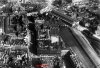
Yes Rowan. That is the New Street Station below on the left. Below the church in the Bull Ring in perspective is the old Market Hall. Immediately below you on the right is Navigation Street, and i am sure others on here will have a tram picture showing "Birmingham Garages" in its proper frontage.
I expect the photo was taken from a not-too-high vantage point from the rear of the Technical College (that was) in Suffolk Street (which only now sort of still is)
Interesting contrast of architecture styles particularly with the "modern" type building dead centre, the front of which (still is anyone?) in John Bright Street.
Richie.