mw0njm.
A Brummie Dude
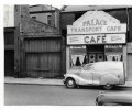
ta lyn thats the one next to the orient flicks, they had 2 shopsi think this is mitchells although the caption says no 30 not 145 so that could be wrong
lyn
View attachment 170605
ta lyn thats the one next to the orient flicks, they had 2 shopsi think this is mitchells although the caption says no 30 not 145 so that could be wrong
lyn
View attachment 170605
I've not seen this picture before, Kelly's 1964 lists the shops as shown.i think thats it were the van is and bloke going in
View attachment 170604
i have always admired those 2 photos viv...the pub looks to be on a corner but not certain...gt russell st was a long streetAnyone know what the pub was on the left (with black lanterns) second photo ? These Phyllis Nicklin photos really captured Birmingham in the 1960s. In my mind, everywhere seemed to be in the process of demolition and/or redevelopment. Any bus journey would take you through building site after building site. At the time I remember thinking it was for the better - being young, we liked new development and new buildings. May not have for been for the better in all cases (and in the long term) but at the time it made us feel part of a city making progress. Viv.
it could be pete..the photo looks to me to be heading down towards farm st and i dont know how many pubs were on gt russell st...difficult to pinpoint this one at the min..will take a look at the gt russell st thread it may give us some clues but from memory i think there was a pub just before farm stwas it the The Justice?
I think it is the St. Matthias PH, the 'lantern' is a sign saying smoke room.
@I think it is the St. Matthias PH, the 'lantern' is a sign saying smoke room.
 birminghamhistory.co.uk
definately newtown row mark as johns photo confirms... think i posted that photo a few years ago on the newtown row thread...great shotThere's a newspaper article in 1900 (Bham Daily Post) that seems to say that a John Morrall, glase and lead dealer was at 113 Newtown Row?
definately newtown row mark as johns photo confirms... think i posted that photo a few years ago on the newtown row thread...great shotThere's a newspaper article in 1900 (Bham Daily Post) that seems to say that a John Morrall, glase and lead dealer was at 113 Newtown Row?
Hello bummy-ladA comparison of Newtown Row in the 1950s to Walmer Lane in 1830. Numerous gardens, a grammar school, the asylum and large tranches of land owned by private individuals and companies (I imagine these owners became mega-rich when the housing boom started).
Not many streets north of New John Street, notably Summer Lane (unnamed), Asylum Road (unnamed), Brearley Street and Porchester Street (unnamed) leading to Aston Furnace.
Hi Bill, here is a link to the 1950s map.Hello bummy-lad
I have looked at your magnificent map which shows Asylum Road highlighted with red line. Is it possible to get a copy of your map as many of my ancestors are from this area and I try to find house numbers of which your map shows.
Bill Tracey
Many thanks brummy-lad, so very helpful.Hi Bill, here is a link to the 1950s map.

