-
Welcome to this forum . We are a worldwide group with a common interest in Birmingham and its history. While here, please follow a few simple rules. We ask that you respect other members, thank those who have helped you and please keep your contributions on-topic with the thread.
We do hope you enjoy your visit. BHF Admin Team
You are using an out of date browser. It may not display this or other websites correctly.
You should upgrade or use an alternative browser.
You should upgrade or use an alternative browser.
New unseen photos with no locations
- Thread starter Astoness
- Start date
oldMohawk
gone but not forgotten
I've had yet another look for that elusive gas holder in post#508. We have generally been successful finding houses but can't find the location of a large gas holder! Did a large factory with furnaces somewhere in Birmingham have its own gas storage facilities? Alcester had a storage gas holder but no significant gas works.
I've had a pleasant aerial tour over the Midlands looking at gas works in photos mostly taken in the years before WW2. There seemed to be a large effort taking photos of gas works which were very much part of town and rural scenes. Unfortunately I can't see the gas holder we are looking for in the list below, but click on any name if you want to see old gas works around the Midlands ... some of them looked nice ...
Bromsgrove 1924
Stafford 1927
Alcester 1928 Gas Storage
Stratford on Avon 1952
Evesham 1935
Stony Stratford 1931
Leamington Spa 1932
Hinckley 1953
Craven Arms 1939
Coventry 1932
Worcester 1934
Smethwick, 1938
Stourbridge 1938
Windsor St Aston 1938
Melton Mowbray 1938
Draycott, 1938
Kidderminster, 1938
Market Drayton, 1938
Wem, 1938
Uttoxeter, 1938
Bromyard, 1938
Tewkesbury, 1938
Pershore, 1938
Tamworth, 1938
Lichfield, 1938
Brownhills, 1938
Cannock, 1938
Hednesford, 1938
Worcester, 1946
Dawley, 1939
Rugeley, 1939
Much Wenlock, 1939
Ironbridge, 1939
Craven Arms, 1939
Ludlow, 1939
Madeley, 1939
Stourport-on-Severn, 1939
Trench, 1939
Welshpool
Wolverhampton, 1936
Last edited:
Viewfinder
master brummie
Great work, OM. I'm partial to the visual effects of a good skeletal gasholder. Here in London we have one of the largest, on the Greenwich peninsula, and a delicately elegant example (Grade II listed) with classical capitals on the slender columns, behind King's Cross station.
Viewfinder
master brummie
No additions to this thread for ages. Any more puzzles to be solved?
Nick Phillips
N S P
I think it's the railway close to Brookfields schoolCould the building with the pitched roof be the GWR buildings on Pitsford street?
Nick S Phillips
Last edited:
roger arrowsmith
New Member
The rag market back of the bullring towards the flower market.hi folks this new thread will show unseen photos i have and also those that mikejee took during 69/73 so we will both be sharing this thread but we need your help to put locations to them..we will give it a couple of days mulling over each photo before posting the next one unless of course the location is sorted before then in which case another one will be posted...once again please feel free to save any of interest and if you want to post them on other forums and sites that is also fine but would appreciate it that if you do you credit them (with thanks to the birmingham history forum..
lyn
here is the first one...i have a feeling thats some of mine will be easy for a lot of you..
Baglin john
New Member
It’s the St Martins hotel in the old wholesale market.hi folks this new thread will show unseen photos i have and also those that mikejee took during 69/73 so we will both be sharing this thread but we need your help to put locations to them..we will give it a couple of days mulling over each photo before posting the next one unless of course the location is sorted before then in which case another one will be posted...once again please feel free to save any of interest and if you want to post them on other forums and sites that is also fine but would appreciate it that if you do you credit them (with thanks to the birmingham history forum..
lyn
here is the first one...i have a feeling thats some of mine will be easy for a lot of you..
Williamstreeter
master brummie
I always liked Ludgate Hill, first discovered when I was exploring the city in the early 80s - the sudden tranquillity away from the centre, dipping perhaps to a subterranean stream, then rising gently to St Paul's church and Square. There used to be a good old pub, St Paul's Tavern, on the right of the rise in the photo - and I was disappointed to see that it had gone when I revisited old haunts in 2013: now an Italian restaurant, if I recall correctly.
I used to use The St Paul's Tavern in the mid 70's , that was when I worked in George St . A little chap named John was the manager , I can't remember the woman that helped out behind the bar . She was in her 50's I think , John always had Wednesday nights off to go and fly his kite
oldMohawk
gone but not forgotten
Every now and then I look at the forum's 'mystery' pics and the one in the quote below first appeared in 2015. A lot of new members have joined since then so maybe someone will have fresh thoughts ... ")
Today I happened to look at the old Smethwick gasworks shown in the aerial pic under the quote, but lack of the unusual house in the location rules it out. It did lead me to read interesting information about the history of the site and it 'bumps up' an old interesting thread ...
Foundry Lane Smethwick 1946 ... the gas holder might have been demolished before the original photos were taken.

Today I happened to look at the old Smethwick gasworks shown in the aerial pic under the quote, but lack of the unusual house in the location rules it out. It did lead me to read interesting information about the history of the site and it 'bumps up' an old interesting thread ...
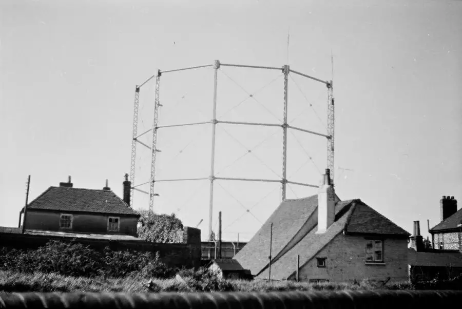
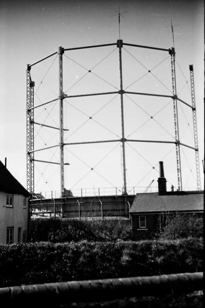
Here are another two that have been on before (or possibly I only put one on). The old thread has gone, but we never determined for certain where this gasholder was . It appears to be incomplete, so presumably was being demolished. The pictures are between ones of a wedding and some of the Moseley St area, but are likely to have been taken on a different occasion than either.
Foundry Lane Smethwick 1946 ... the gas holder might have been demolished before the original photos were taken.
")
oldMohawk
gone but not forgotten
There were three gas holders at Crossgates and two were demolished at some unknown date. The map shows a Nursery area which has since been replaced by a shopping centre.

The largest of the gas holders is amazingly still there but although the photo below shows solid horizontal struts, the uprights are also solid. The original photo shows lattice uprights so must be a different gas holder although I've not yet found photos of the gas holders before demolition in order to check the uprights.

The largest of the gas holders is amazingly still there but although the photo below shows solid horizontal struts, the uprights are also solid. The original photo shows lattice uprights so must be a different gas holder although I've not yet found photos of the gas holders before demolition in order to check the uprights.
The City Meat Market is the large building on the right. It was built in 1897 so quite new when this photo was taken.It cost I £127,833 and covered 3.5 acres. The tower was in fact a water tower and the round building was the Round House where I first started work in 1952. The Architecture was typically Victorian and designed to look more like something from the Middle East. Inside were wrought ironwork pillars and galleries. Today buildings like that would be preserved but the then City Engineer Mr Manzoni swept many of these iconic examples of our past away. If any one has more photos of the market I'd love to see them.I guess the meat market was pretty close to the Drovers Arms. That area of the city was not one I ventured often. I recalled seeing an old 'photo, on this site I am sure, of sheep being driven in Bradford Street.
I can confirm that sheep and cattle were driven down Bradford st from Fazeley station. I fact in the 1950's I bought livestock in Gloucester market on a Monday morning where they were loaded on to wagons at the railhead adjacent to the market arriving in the City Meat Market by late afternoon. Cattle were driven down Bradford St in herds reminiscent of the Wild West. Occasionally a beast would break away and charge up to the Bull Ring causing consternation among shoppersI guess the meat market was pretty close to the Drovers Arms. That area of the city was not one I ventured often. I recalled seeing an old 'photo, on this site I am sure, of sheep being driven in Bradford Street.
Hollyhinks
New Member
Might be the Castle Inn on Church Lane
Linda Foxall
New Member
Just read this and yes it is Thomson’s sweet shop that sold toys too. I lived at 135 Kyrwicks laneBelow is one where Phil has suggested a location , but was not sure, though it was taken after one of the Stratford arms in Kyrwicks Lane , which would make his atribution likely. Wwould be nice if someone else finds it famiiar.
The three-quarters-covered name on the shop to the right of centre reads Thompson. There is an S.J. thompson in Deakins road, but this seems unlikely. Phil has suggested that it might be Kyrwicks Lane, and there was a Lilian Gertrude Thompson , shopkeeper, at 97 Kyrwicks Lane, which fits with the parts of the remaining letters that can be seen.
Thompsons and next door to the right a green grocers, then a bit of waste ground and the entrance to our yard where I lived at 8/91. Next to that Coley's the grocer which was very modern with glass counter and a bacon slicer which I longed to have a go with. Happy memories.Just read this and yes it is Thomson’s sweet shop that sold toys too. I lived at 135 Kyrwicks lane
First thoughts from me was the old Rag Market so agree with O.P. Edgbaston Street looking towards St Martin’s, Jamaica Row and the ‘top end’ of Digbeth.Lynn not sure of the street,but is it Edgbaston Street? I remember from that street you could get to the bus station and also a back entrance into the actual Bull Ring. (or Bullring!!). lol
This is Edgbaston st top of Digbethhi folks this new thread will show unseen photos i have and also those that mikejee took during 69/73 so we will both be sharing this thread but we need your help to put locations to them..we will give it a couple of days mulling over each photo before posting the next one unless of course the location is sorted before then in which case another one will be posted...once again please feel free to save any of interest and if you want to post them on other forums and sites that is also fine but would appreciate it that if you do you credit them (with thanks to the birmingham history forum..
lyn
here is the first one...i have a feeling thats some of mine will be easy for a lot of you..
Roger Baker
master brummie
I remembered that view quite well Jimbo. On most views others would usually be far better.
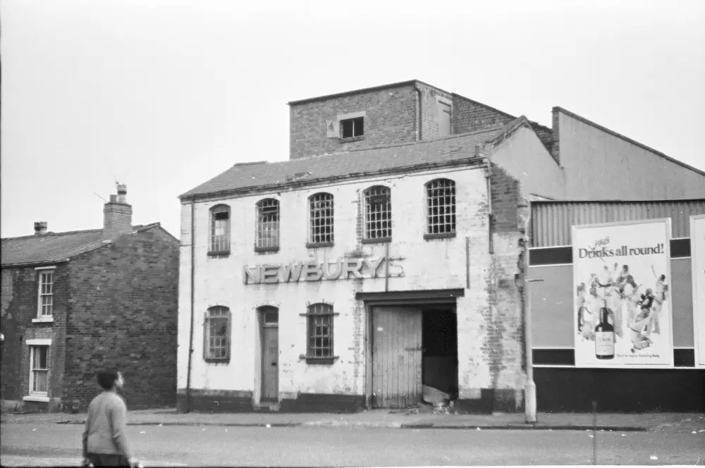
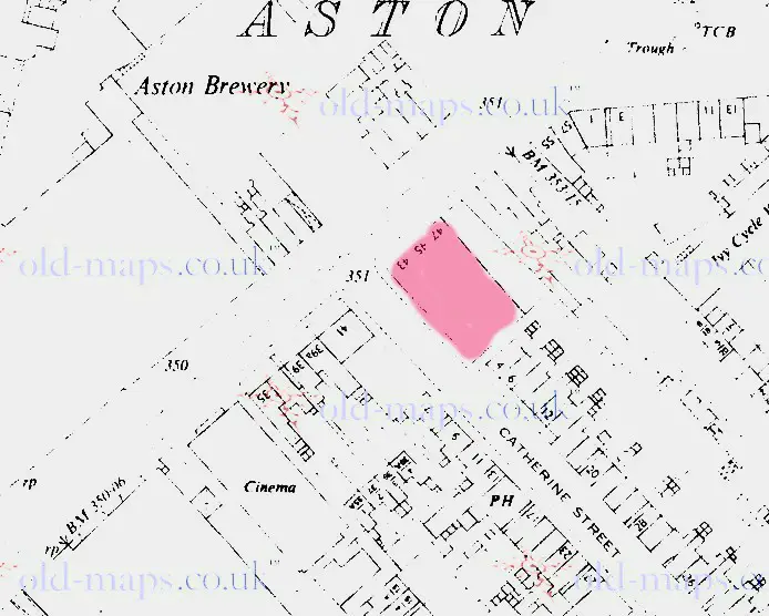
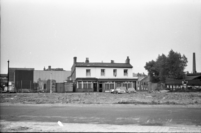
The next one has already been on the 1969-73 thread and a possible/ position listed, but , to me the map doesn't look right, so if anyone can confirm the position i'd be very grateful. The photo was taken around 1970 and ones taken around it were all in the church lane Aston area. It shows what had been Newbury's. the directories give address as 43-47 Lichfield road, but before no one remembered it and the map of the area doesn't look quite like it. Apart from the fact that it doesn't look much like I remember Lichfield road it seems to show one building on the site and the houses to the left look too far away . On c1938 maps the site is three separate buildings (and this building looks pre 1938 to me). I have marked it in red on the map. Maybe someone remembers it there, or perhaps at another place. If not I think I will have to say it was definitely at 43-47.and that the OS maps did not giove a very good representation.

with ref to mikes other unknown pub pic 1 and as the new adventurers pub corner of queens road and grosvenor road has been mentioned i popped down there today took these photos of the pub which is now a car lot..in mikes photo we can clearly see a chimney stack to the right...if you turn out of grosvenor road and turn left onto the lichfield road just a little way up on the right is part of a chimney stack...it has obviously been cut down a lot as it only say bros ltd on it so the name of the company is missing so maybe we are in the right area as mike did take photos around lichfield road... this is my last effort to solve this one..must move on lol
lyn
Hi, I'm extremely late to this but this pub is the Crown inn, Church Rd at Alfred Street, Aston. I found it on the Lost Pubs ProjectPhil
That was the one I was going to put up next. Here it is. It was in the midst of several around church lane Aston. It is obviously a pub, but have been unable to identify it. The highest resolution seems to show Mitchells & Butlers on the fascia.
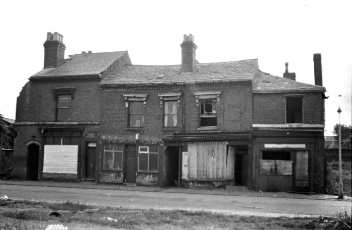
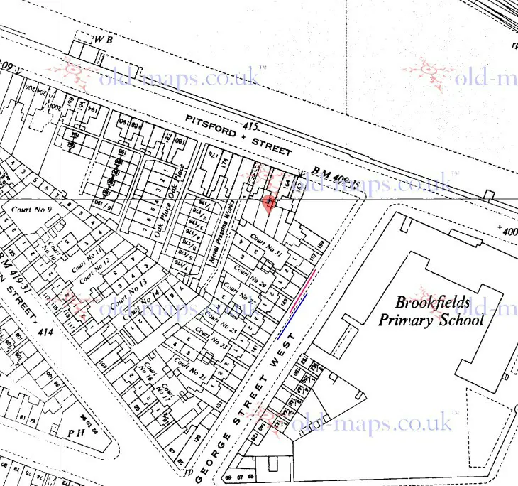
Hi MikeI think that that is the solution, and that the first photo is definitely the back of the building in the second photo. The (now unreadable) plaques above the alleyways in picture two show that these must lead to courts, which would originally been named or numbered on them., The position of the alleyways to the back courts, together with the closeness of the railway buildings, limits which houses it could be. I have concluded, and would welcome comments, that on the c1955 map below. the buildings illustrated must be either nos 149-155 (fronting court 31 and marked with a red line in front of them) or 145-151 (fronting court 29, and with blue line in front of them). I think 149-155 is the most likely as the rail buildings do seem quite close.
I think that that is the solution, and that the first photo is definitely the back of the building in the second photo. The (now unreadable) plaques above the alleyways in picture two show that these must lead to courts, which would originally been named or numbered on them., The position of the alleyways to the back courts, together with the closeness of the railway buildings, limits which houses it could be. I have concluded, and would welcome comments, that on the c1955 map below. the buildings illustrated must be either nos 149-155 (fronting court 31 and marked with a red line in front of them) or 145-151 (fronting court 29, and with blue line in front of them). I think 149-155 is the most likely as the rail buildings do seem quite close.
HelI think that that is the solution, and that the first photo is definitely the back of the building in the second photo. The (now unreadable) plaques above the alleyways in picture two show that these must lead to courts, which would originally been named or numbered on them., The position of the alleyways to the back courts, together with the closeness of the railway buildings, limits which houses it could be. I have concluded, and would welcome comments, that on the c1955 map below. the buildings illustrated must be either nos 149-155 (fronting court 31 and marked with a red line in front of them) or 145-151 (fronting court 29, and with blue line in front of them). I think 149-155 is the most likely as the rail buildings do seem quite close.
Hello Mikejee this is the first time I’ve seen these 2 photos and can say with out doubt pic1.is 1 to 5/190 Pitsford St. having worked on this block before demolition, unusual for us to do much in this street as this was FCCs patch but I think this was Mayfield Terrace. and being back to back, just showing is what’s left of a toilet block , one of several pairs resently refurbished, all this positioned Just down from the entrance to the GWR goods yard. But as for picture no2.something tells me that was George st.West just around the corner from Pitsford st. and first property on the left we had to re-sheet the front door twice + hook & eye & padlock Which was a new idea for us when sheeting up voids as someone was running riot with tin snip’s on the area, but that’s a road in front of this terrace, reminds me of Clissold st. between Hingeston & Pressott st. during demolition 1967. But briefly back to Pitsford st. having done some work on refurbishing toilet blocks and obstructied drains back of 170. I don’t see any toilet blocks or brew houses on those plans shown above, these toilets being inclosed pan’ planks not dissimilar from those in Abbey st. Iate 60s early 1970. But anyway I hope this information is of some interest to that discussion of 2015.I think that that is the solution, and that the first photo is definitely the back of the building in the second photo. The (now unreadable) plaques above the alleyways in picture two show that these must lead to courts, which would originally been named or numbered on them., The position of the alleyways to the back courts, together with the closeness of the railway buildings, limits which houses it could be. I have concluded, and would welcome comments, that on the c1955 map below. the buildings illustrated must be either nos 149-155 (fronting court 31 and marked with a red line in front of them) or 145-151 (fronting court 29, and with blue line in front of them). I think 149-155 is the most likely as the rail buildings do seem quite clos
I think that that is the solution, and that the first photo is definitely the back of the building in the second photo. The (now unreadable) plaques above the alleyways in picture two show that these must lead to courts, which would originally been named or numbered on them., The position of the alleyways to the back courts, together with the closeness of the railway buildings, limits which houses it could be. I have concluded, and would welcome comments, that on the c1955 map below. the buildings illustrated must be either nos 149-155 (fronting court 31 and marked with a red line in front of them) or 145-151 (fronting court 29, and with blue line in front of them). I think 149-155 is the most likely as the rail buildings do seem quite close.Hello Mikejee this is the first time I’ve seen these 2 photos and can say with out doubt pic1.is 1 to 5/190 Pitsford St. having worked on this block before demolition, unusual for us to do much in this street as this was FCCs patch but I think this was Mayfield Terrace. and being back to back, just showing is what’s left of a toilet block , one of several pairs resently refurbished, all this positioned Just down from the entrance to the GWR goods yard. But as for picture no2.something tells me that was George st.West just around the corner from Pitsford st. and first property on the left we had to re-sheet the front door twice + hook & eye & padlock Which was a new idea for us when sheeting up voids as someone was running riot with tin snip’s on the area, but that’s a road in front of this terrace, reminds me of Clissold st. between Hingeston & Pressott st. during demolition 1967. But briefly back to Pitsford st. having done some work on refurbishing toilet blocks and obstructied drains back of 170. I don’t see any toilet blocks or brew houses on those plans shown above, these toilets being inclosed pan’ planks not dissimilar from those in Abbey st. Iate 60s early 1970. But anyway I hope this information is of some interest to that discussion of 2015.
Last edited by a moderator: