
-
Welcome to this forum . We are a worldwide group with a common interest in Birmingham and its history. While here, please follow a few simple rules. We ask that you respect other members, thank those who have helped you and please keep your contributions on-topic with the thread.
We do hope you enjoy your visit. BHF Admin Team
You are using an out of date browser. It may not display this or other websites correctly.
You should upgrade or use an alternative browser.
You should upgrade or use an alternative browser.
New John Street West and Great Russell Street
- Thread starter RichSmith
- Start date

MWS
from Bham
Hello Lyn, I think it was no. 366.
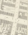
A license transfer to a J Short for the Bank Tavern is mentioned in the newspaper in 1890 and he appears to be listed aa a licensed victualler at no. 366 New John St West though no pub name is listed on the 1891 census. This does however tie in with the numbers listed on the 1954 map by which time it appears to have split into three - 366, 366A and 366B.
A license transfer to a J Short for the Bank Tavern is mentioned in the newspaper in 1890 and he appears to be listed aa a licensed victualler at no. 366 New John St West though no pub name is listed on the 1891 census. This does however tie in with the numbers listed on the 1954 map by which time it appears to have split into three - 366, 366A and 366B.

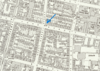
thanks mark...so looking at below map it stood in the middle of what is the duel carriageway of new john st west..as usual just move the blue dot to the left..
Last edited:


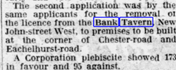



Here it is.
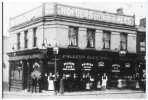
thanks jan and that has now goneThe new building on the corner of Eachelhurst Road and Chester Road seems to be the Bagot Arms
lyn

RichSmith
master brummie
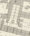
In the vicinity is my great grandfathers court... 47 court, how would the numbering work would it be 1 starting on the left and going round clockwise? His house was 47 court 9 house and later when the addresses changed in the early 20's 9 back of 359
Attachments
MWS
from Bham
On the 1954 map most of the court ha gone but the four houses that back onto the 'street' houses are still there. They are list no. 1 behind 359 to no. 4 behind 356.
Assuming there numbers remained the same I would have first said that no. 9 would have been the last house but one of the left row (house numbers going clockwise. However, as you sat the 20's census lists it as 9 back of 359 it is possibly the last but one house of the right row maybe. Just surmising though.
What are the other houses in the court listed as? If some are listed back of 356 then I think you would be confident in saying it is one of the right row.
Assuming there numbers remained the same I would have first said that no. 9 would have been the last house but one of the left row (house numbers going clockwise. However, as you sat the 20's census lists it as 9 back of 359 it is possibly the last but one house of the right row maybe. Just surmising though.
What are the other houses in the court listed as? If some are listed back of 356 then I think you would be confident in saying it is one of the right row.
as already said the houses in court 47 had gone quiet early i think...the best map showing the lay out of the houses before demo is the map shown on post 1
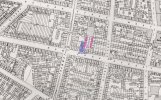
just found this map on the new john st west thread from mike when researching something else...court 47 is in red map dated 1889 very often its anyones guess as to how the houses in courts were numbered and i think we are very lucky to have maps available that show the courts...
lyn
lyn
Last edited:
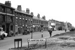
it pays to check other threads....just been back to the new john street west thread and up pops this photo..it clearly show weldons factory as shown on the map on post 19 to the right of weldons shows the entries to what would have been court 47..the first entry would have been used to access the houses on the left of court 47 the second entry used to access the houses on the right of court 47
lyn
lyn
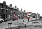
rich ive just added to my previous post..the entry you have circled could be the one your gt grandad used providing no 9 was on the right hand side of court 47...if however no 9 was on the left hand side of court 47 he would have accessed his house via the entry next to weldons...
lyn
lyn

brummy-lad
master brummie
RichSmith
master brummie
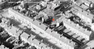
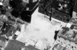
WOW!!!An aerial view from 1948. it looks like some of the houses on the left-hand side of the court have already gone. I can find no records of bombing in that area.
hi john there was 2 injuries at new john st west...i dont think that there are any records to show bomb damage unless they are fatal or injured so its possible those houses did suffer bomb damage or the were just demolished
brummy-lad
master brummie
brummy-lad
master brummie
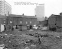
just beat me to it john...so i think its safe to assume that the children standing on waste ground is the ground where court 47 was..weldons on the right and we can clearly see both entries that gave access to court 47...Just came across this which I posted on another thread 4 years ago.
lyn
brummy-lad
master brummie
Sorry about that Lyn, it was your post on the other thread that led me to it. It was probably one of yours originally.just beat me to it john...so i think its safe to assume that the children standing on waste ground is the ground where court 47 was..weldons on the right and we can clearly see both entries that gave access to court 47...
lyn