Several threads have been merged into this one on the subject of Nechells Park Road. Therefore there may now be unseen posts on this thread. Viv.
Last edited:
 birminghamhistory.co.uk
Thank you! That's really helpful.The online electoral rolls do not seem to list it, but the 1921 Kellys shows it as between 28 & 29. The rolls call the houses "back 28". The map below shows them in red.
View attachment 178506
Hi Frank (or whoever is asking), are you still researching family history lined to 7/23 or 7/24 Nechells Park Road? If so I'm keen to help or be helped with the smith family (Thomas & Ada, daughter Frances) on behalf of my wife. Regards, Alan.I am trying to research family history. I was born 1931 and lived with my parents at what i understood was my grandparents home at 7/24 nechelles park road. Searching the 1901/11 cencus does not reconise this address. What happend to it.
Hi Frank (or whoever is asking), are you still researching family history lined to 7/23 or 7/24 Nechells Park Road? If so I'm keen to help or be helped with the smith family (Thomas & Ada, daughter Frances) on behalf of my wife. Regards, Alan.
hi family history as this is a family research topic could you please repost your enquiry under our surname interests of the forum please..i am sure you will receive some help..Hi MWS. I was trying to find out the location and any family links with either 7/23 or 7/24 Nechells Park Road. My wife's father was born at 77 Dudley Avenue/Rd in 1929 (which I think from info on this site was a hospital from 1920 to 1948. The birth certificate states 7 Bk 24 Nechells Park Road, but the 1921 Cencus entry (for the same names and family members) states 7/23 NPR. We recently had a DNA match with a lady in Canada (Vancouver Island, BC) whose dad (Joseph W Smith) was born in and lived at 7/24 NPR. So that helped us find more info on Harold Smith (whose mum was the older sister of JW Smith). I know the area has been redeveloped, but the old maps show old buildings very well.
Sorry it's a bit of a Family History request, but we are intrigued by the history of that part of Birmingham (if not the whole city). Many Thanks.
Hi @Em1906Hi. Does anyone know where 8 Marton Place Nechells Park Road once was? In 1911 there was an Albert Edward Stanley living there. Many thanks
just looking at the top left corner of this map...i wonder why it was called south pole cornerThe online electoral rolls do not seem to list it, but the 1921 Kellys shows it as between 28 & 29. The rolls call the houses "back 28". The map below shows them in red.
View attachment 178506
The question has been asked several times in the local papers, but no0ne seems to have come up with an answerjust looking at the top left corner of this map...i wonder why it was called south pole corner
lyn
oh right thanks mike...it will remain a mystery for now thenThe question has been asked several times in the local papers, but no0ne seems to have come up with an answer

In my younger days a lady's two piece suit was known as a 'costume'. Does this help with the conundr
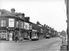
Thank you so much! And thanks to everyone else, I've really enjoyed looking at everyone's photos and reading about your memories of Nechells.Welcome to the forum. The shop was a 325 Nechells Park Road, which was on the corner of Butlin Road. The present view is at https://maps.app.goo.gl/SJgHSqtdQBVDzheR6
hiking costume sound more like it thnks LPIn my younger days a lady's two piece suit was known as a 'costume'. Does this help with the conundrum?
Hello. Apologies for my very late response, have just seen your item today. Yes, i agree with the person who says the corner of Butlin Street. The first car is parked outside of Nechells Park Road. The next turning, just past the second car (van) is Malvern Hill Road and in the far off distance can be seen the Villa Tavern, on the corner of Holborn Hill, which I believe is still these.. Bill AustinView attachment 188607
Hello everyone, I am a teacher at St Clements Academy on Butlin Street just off Nechells Park Road. I am trying to find out whereabouts the H Mansell shop shown in this photograph was. I've seen explanations on here saying it is on the corner of Holborn Hill but if that is the case then it would be on the crossroads with Aston Church Road. I've also seen people suggesting that Butlin Street is on the left so the shop would be on the corner of Butlin Street, can anyone confirm this? I'd like to take a photo of what this looks like now so that we can compare the two photographs.
The online electoral rolls do not seem to list it, but the 1921 Kellys shows it as between 28 & 29. The rolls call the houses "back 28". The map below shows them in red.
View attachment 178506

