• Welcome to this forum . We are a worldwide group with a common interest in Birmingham and its history. While here, please follow a few simple rules. We ask that you respect other members, thank those who have helped you and please keep your contributions on-topic with the thread.

    We do hope you enjoy your visit. BHF Admin Team

Maps of Back to backs in Birmingham?

TonyQ

proper brummie kid
Having visited the NT Back to Backs yesterday, and having relatives who we know did living in such housing, I'm struck by the thought that back to back housing would have been built in specific areas of the town as it expanded in later Victorian times. So are there any maps showing which areas of the town had such housing and in which period, please?

 
The Victorian back2backs were still around into the 60s/70s. I have never come across any data like that as they were dotted all over Birmingham and not confined to any particular area.

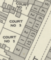
On the NLS maps they are typified by this arrangement.
1788452267719.png
 
Thank you. I'm aware of those, but wondered if anyone had annotated something like that to show which areas were back to backs and when they were built.
I've never seen such mapping or annotation. Back to Backs were built all over the city and as @brummy-lad said were occupied in some cases into the 1960s. Janice Heppenstall has a useful post on her blog https://englishancestors.blog/tag/birmingham-back-to-backs-museum/

Looking at addresses written 12/6 or 'back of' and mention of a numbered or named court is an indication. On a large scale map there's a dividing line down the middle of each back to back house which has a different number.
 
Back
Top