• Welcome to this forum . We are a worldwide group with a common interest in Birmingham and its history. While here, please follow a few simple rules. We ask that you respect other members, thank those who have helped you and please keep your contributions on-topic with the thread.

    We do hope you enjoy your visit. BHF Admin Team

map of 4/19 guildford st

Astoness

TRUE BRUMMIE MODERATOR
Staff member
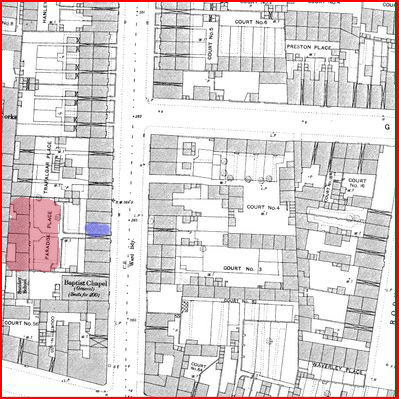
hi mike..when you have time im looking for a map showing paradise place which was at 4 back o 19 guildford st please...im only guessing but looking at the pics of guildford i have it would be at the farm st end on the right looking up...

thanks mike..:)

lyn
 
Lyn
Looks like you were almost right. The little bit of road at the bottom of the map is Farm St, so it couldn't be much nearer that end, but it is on the left looking up. The houses either side of the entrance are 17 & 19.
Mike

paradise_place2C_guildford_st_near_Farm_St.JPG
 
Last edited:
mike on your map 19 is by the chapel.....by luck i have a pic looking straight up guildford from farm st..the chapel is on the left just by the van so could you mark out number 19 is please.looks like we can see it on this pic...

many thanks mike...

lyn
 
Here you are Lyn. the entrance to Providence place is to the left of 19, marked blue on the map
Mike

paradise_place2C_guildford_st_near_Farm_St.JPG
 
mike it paradise place....thanks everso much i thought it was very close to the chapel...

lyn.x
 
Great Stuff Mike my Grandmother lived at 12 Guildford Terrace Guildford Street and was married from there 6/02/1895 any chance you can point it out please.

Lyn I've seen the photo on the Forum before but I'm please about the extra inflormation
 
Last edited:
Alf
I thought your request would be easy to answer, but the exact opposite. No maps seem to name Guildford Terrace, and it does not appear in the 1912 or 1920 electoral rolls. /The only place I have found it is in the 1873 directory, which is unfortunately un-numbered (as some to the streets were in early days), but which does place it on the east side of the street between Clifford st & Gerrard St. Examining the 1889 large scale map in combination with directories and the electoral roll enabled me to place all the named terraces between those two roads. This left “Court 12” comprosing two terraces facing each other . By a process of elimination , Guildford Terrace must be one of these (or possibly both together) . Perhaps (and I am only guessing) officialdom found Guildford terrace and Guildford Road a bit confusing and therefore used the Court 12 name, while occupants still used the Guildford Terrace name, as it was likely engraved in brick on the wall somewhere.
Have marked all the terraces in that part of the road in red in case it is of interest
Hope that is useful
Mike

guildford_st_between_clifford_st_and_gerrard_st.jpg
 
Back
Top