I am researching the Comley family. In the 1841 Census the family (without George Comley, the head of the household, who was in prison in Gloucestershire) were living in Lower Hurst Street. What was this street at the time? Slum, working class, or more prosperous? By '51, they had moved to Union Street, St Phillips. Would this have been a move up in the world?
-
Welcome to this forum . We are a worldwide group with a common interest in Birmingham and its history. While here, please follow a few simple rules. We ask that you respect other members, thank those who have helped you and please keep your contributions on-topic with the thread.
We do hope you enjoy your visit. BHF Admin Team
You are using an out of date browser. It may not display this or other websites correctly.
You should upgrade or use an alternative browser.
You should upgrade or use an alternative browser.
Lower Hurst Street
- Thread starter Sue Ross
- Start date
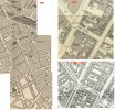
At that time Lower Hurst St was a relatively new Street. the map of 1839, which would refer to a few years before, shows (below in green) where the street would be, but there appear to be no buildings yet on it. The 1845 Post Office directory shows a mixed business community (see below), with working class courts off the street, but also with jeweller, an auctioneer and the Hebrew National School.


The generallayaout of the street, including the courts, was probably similar to that in the c1889 map below

The generallayaout of the street, including the courts, was probably similar to that in the c1889 map below
www.midlandspubs.co.uk
Pub Historian
Before uploading any pub info for Hurst Street, I have done a bit of blurb which may be of interest to you Sue.
See : https://www.midlandspubs.co.uk/birmingham/hurst-street/
See : https://www.midlandspubs.co.uk/birmingham/hurst-street/
AnnieB
master brummie
I am looking for a second pair of eyes to confirm my research please. In 1871 England census, my 2 x and 3 x great grandmothers, Georgina Allen and Eliza Allen, together with a lodger, Sarah Dunn, were living at '5Ct 3 Ho Lower Hurst Street. Is someone able to show this on a map for me please? TIA


AnnieB
master brummie
Thank you so much! I needed to be the other side of Bromsgrove Street to tie in with the 'Lower Hurst Street'. I see that the side nearest the Hippodrome is just 'Hurst Street'.Typical it is split between 2 sections of map. I've "stitched" two sections together (circa 1887) but will also post another map whch is a different scale (circa 1913)
Court 5 in blue
View attachment 196862View attachment 196863
AnnieB
master brummie
Yes. I had looked at several maps although your map confirmed the location after reading the route the enumerator took in 1871. I needed to make sure and your help has achieved this - again, thank you.I think by the second map it was all just Hurst Street but in the 1880s the one part was Lower Hurst Street.
Solihull Girl
proper brummie kid
Hi all, I am new to the site and came across it when looking for information on Anne Burley nee Davis (widowed) who in 1861 lived at 60 1 Court 20, Lower Hurst St East, Birmm. She is stated to be an iron founder employing 5 men and 4 boys. The maps previously linked to this thread are extremely interesting. Was this housing the equivalent of today's tower blocks? Thanks in advance for any info.
brummy-lad
master brummie
Hi Solihull Girl, welcome to the forum.
Looking at the 1861 census the listing seems to be:
Court 1, Houses 1 to 3
Then No. 5 through to 20 (Anne Burley) I think No. 20 was an individual property, not a court.
Trying to find a map but quite difficult as Lower Hurst Street East, I think was renamed and renumbered.
Looking at the 1861 census the listing seems to be:
Court 1, Houses 1 to 3
Then No. 5 through to 20 (Anne Burley) I think No. 20 was an individual property, not a court.
Trying to find a map but quite difficult as Lower Hurst Street East, I think was renamed and renumbered.
Last edited:
Solihull Girl
proper brummie kid
Hi Brummy LadHi Solihull Girl, welcome to the forum.
Looking at the 1861 census the listing seems to be:
Court 1, Houses 1 to 3
Then No. 5 through to 20 (Anne Burley) I think No. 20 was an individual property, not a court.
Trying to find a map but quite difficult as Lower Hurst Street East, I think was renamed and renumbered.
Thanks for the info. It would make sense if it was a single property as they had a servant! Plus I am assuming that an iron founder who employed staff would be better off than the poorer folk crammed into court houses.
brummy-lad
master brummie
brummy-lad
master brummie
The 1861 directory lists 20 Lower Hurst St East as Ann Burley & Son, ironfounders, They are not there in the 1867 directory. In the 1858 directory it is just Ann Burley, ironfounder, with no son, while in 1845, 1849 and 1855 it is Richard Burley, ironfounder. He in 1841 directory is listed as a may have changed occupations to being an ironfounder as Richard Burley (assuming it was the same one) is a beer retailer at 45 court . Cheapside

Solihull Girl
proper brummie kid
Hi Brummie LadThe 1861 directory lists 20 Lower Hurst St East as Ann Burley & Son, ironfounders, They are not there in the 1867 directory. In the 1858 directory it is just Ann Burley, ironfounder, with no son, while in 1845, 1849 and 1855 it is Richard Burley, ironfounder. He in 1841 directory is listed as a may have changed occupations to being an ironfounder as Richard Burley (assuming it was the same one) is a beer retailer at 45 court . Cheapside
Thanks so much for this information. Richard Burley died in 1855 and his wife Ann carried on the business. I hadn't got around to checking the directories, so will have a look now.
SG
brummy-lad
master brummie
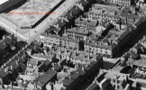
Hi SG, judging my Mike's map in post #17 I imagine that the property can be seen on the aerial view in post #15.
BTW it was Mike who checked out the directories, I was hoping he would get involved in this thread, he's one of BHF's most knowledgeable members.
BTW it was Mike who checked out the directories, I was hoping he would get involved in this thread, he's one of BHF's most knowledgeable members.
Hi Mike. This is all very fascinating and excellent research. I have just recently discovered that my great great granddad lived with family and lodgers between two properties. 3 court 1 house, and 3 court 2 house Lower Hurst Street, according to the 1871 census. Could you or someone help me locate those properties on the map pleaseAt that time Lower Hurst St was a relatively new Street. the map of 1839, which would refer to a few years before, shows (below in green) where the street would be, but there appear to be no buildings yet on it. The 1845 Post Office directory shows a mixed business community (see below), with working class courts off the street, but also with jeweller, an auctioneer and the Hebrew National School.
View attachment 143848View attachment 143849
The generallayaout of the street, including the courts, was probably similar to that in the c1889 map below
View attachment 143850
if you go to post 7 court 3 is marked on a map..it is always advisable to start reading a thread from post 1 so that you do not miss anything...Hi Mike. This is all very fascinating and excellent research. I have just recently discovered that my great great granddad lived with family and lodgers between two properties. 3 court 1 house, and 3 court 2 house Lower Hurst Street, according to the 1871 census. Could you or someone help me locate those properties on the map please
lyn
Thank you, my great grand dad was William Wooley, Blacksmith. I did look through all the posts, but thought that was a number 5? and is referred to as number 5, or maybe I'm looking at the wrong post? perhaps if I use logic can I assume that 3 is simply 2 courts away? having trouble making out the numbers, and can't see where 1 would beif you go to post 7 court 3 is marked on a map..it is always advisable to start reading a thread from post 1 so that you do not miss anything...
lyn

brilliant thank you!Court 5 is 2 above the highlighted court. Here is the left-hand map with court 3 underlined, Saying which houses were no. 1 and 2 would be a bit of a guess...
View attachment 212229
Could I ask just one more small favour please, the numbering and naming convention they seemed to use in the census was 3 court 1 house can I assume from your information that this means court 3 house number 1? sorry to sound stupid but I'd like to be certain. Thanks againbrilliant thank you!
Thank you all again very much. The family also moved to Vere Street and Hope Street later so I'll do some searching on the general forumYes, that's right.
