-
Welcome to this forum . We are a worldwide group with a common interest in Birmingham and its history. While here, please follow a few simple rules. We ask that you respect other members, thank those who have helped you and please keep your contributions on-topic with the thread.
We do hope you enjoy your visit. BHF Admin Team
You are using an out of date browser. It may not display this or other websites correctly.
You should upgrade or use an alternative browser.
You should upgrade or use an alternative browser.
looking for a brougham st map
- Thread starter Astoness
- Start date
davidfowler
Exiled Brummie
Morning Lyn
I've looked on my Godfrey Ed maps but only have 8.13 (Aston Manor) which isn't quite close enough. It looks like it should be on 7.16 (Handsworth) if anyone has that one.
David
I've looked on my Godfrey Ed maps but only have 8.13 (Aston Manor) which isn't quite close enough. It looks like it should be on 7.16 (Handsworth) if anyone has that one.
David
Alf
Gone but not forgotten. R.I.P.
Not sure if this is the one Lyn but....
https://maps.google.com/maps?q=brou...um=1&sa=X&oi=geocode_result&resnum=1&ct=title
https://maps.google.com/maps?q=brou...um=1&sa=X&oi=geocode_result&resnum=1&ct=title
john knight
signman
Or 13.04 Winson Green , I have just sent for both, but I'm sure someone on here will have one.
mike .. just had a good look at that map you posted and its of even more interest to me than i thought as it also shows the whole of the bottom end of villa st as far as bridge st west...my other map only went half way down villa st...
thanks again.
lyn")
thanks again.
lyn
grandaughter82
master brummie
Hi I've just found out my nan lived in Brougham St in 1939 when she was 18 (lived there since birth)
could I see the earliest map you have around that time please?
She lived at number 141 and 18 years old worked at I think the letters are EP warehouse - no idea where or what that was was but its mentions she did the wrapping.
All my mom knows and mentioned to me was that it was where she met her husband to be (my moms dad)
I've just read through the Brougham St thread on here (love doing this gives me a feel for the street) got a couple of pics at a later date but least its something to show mom.


here is the entire map of brougham st lozells...as MWS has said it did not go up to anywhere near 141...maybe you could double check the number it may have been 41 failing that if you give me your nans parents names (assuming she lived with her parents) i could check the electoral rolls for you on ancestry as you had to be 21 to be on the electoral rolls
lyn

lyn
grandaughter82
master brummie
Oh thank you!
Just had another look at the paperwork and was looking in completely the wrong place I didn't see the number before the street name.
My moms now questioning if I even have the correct street
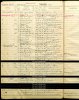
I have attached the document. (their handwriting was so hard to make out in them days.
They are at the top, where the red mark is - no idea where I'm supposed to look for that either (what the red mark mentions)
Just had another look at the paperwork and was looking in completely the wrong place I didn't see the number before the street name.
My moms now questioning if I even have the correct street
I have attached the document. (their handwriting was so hard to make out in them days.
They are at the top, where the red mark is - no idea where I'm supposed to look for that either (what the red mark mentions)
Attachments

grandaughter82
master brummie
Thank you so much!
oh and noticed there is a warehouse next door!!!! This must be the warehouse she worked in.
oh and noticed there is a warehouse next door!!!! This must be the warehouse she worked in.
i think EP warehouse stands for electro plating warehouse..there were a lot of them around in those days and you are so very lucky because without looking i know that i have posted a photo of no 7 brougham st on the brougham st thread....but here it is again...you can clearly the number 7 on the door ..house on the far left
lyn

lyn
Last edited:
grandaughter82
master brummie
oh wow!!!!! thank you so much mom will love this!
Any idea when this photo was taken?
thank you so much.
Any idea when this photo was taken?
thank you so much.