• Welcome to this forum . We are a worldwide group with a common interest in Birmingham and its history. While here, please follow a few simple rules. We ask that you respect other members, thank those who have helped you and please keep your contributions on-topic with the thread.

    We do hope you enjoy your visit. BHF Admin Team

Linwood Road Handsworth

Vivienne14

Kentish Brummie Moderator
Staff member
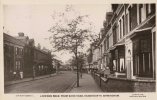
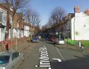
This shows Linwood Road c1921 from the junction with Dawson Road - I think. The house(s) to the right might have been demolished (maybe WW2 damage perhaps ?).

There are a number of name plaques along this road. On the right of the photo : Blackwell Villas (above #12 and #14), Pamela Villas (above #16 and #18), Alfred Villas (between #26 and #28), Victoria Villas (between#30 and #32), Gordon Villas (between #46 and #48)

Plaques on the left: Belmount Villas (between #9 and #11), Richmond Villas (between #13 and #15), Dunchurch Villa (#25) Priory Villa (#27), Cefnhendre House (#49),Hawthorn Villas (between #51 and #53), Pine Wood Villas (between #59 and #61), Clent House (#83).
Screenshot_20260810_194509_Chrome.jpg
Screenshot_20260810_204318_Maps.jpg
 
Last edited:
not sure if this helps viv but there was 2 people injured during ww2 one at no 128 the other at no 136

Last NameForename(s)Date of InjuryLocation of InjuryAgeCivil Defence Status
ParryPercy11/12/1940136 Linwood Road, HandsworthCivilianView
WrightJane11/12/1940128 Linwood Road, HandsworthCivilianVie
 
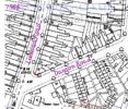
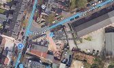
Thanks Lyn. After a bit more digging, the corner house at #10 Linwood Road (at the junction with Dawson Road) was once a shop - one of our members lived there and mentioned it on the Soho Road thread. It was opposite a wood yard on the corner of Dawson. The member lived there in the mid-1960s and after they moved a company called Dorwingear may have taken it over. Dorwingear may have been there into the 1970s. The shop/premises at #10 were definitely demolished in peace-time, possibly in the 1970s. A 1956 map shows the corner house/shop (#10 red dot) still there. Recent Streetview images show the whole plot being built on/developed.


For info, it's claimed on the Soho Road thread that no WW2 bombs fell on Linwood Road, but there was a bomb site nearby, possibly Baker Street/Dawson Road after the War. The site seems to now be home to King Edward VI Handsworth School with very little of Baker Street surviving today.

Screenshot_20260811_111743_Samsung Browser.jpg
Screenshot_20260811_110903_Maps.jpg
 
Last edited:
well that is odd viv as my post 2 shows from the BARRA site that there was bomb damage and injuries at 2 houses on linwood road and i have always found the site to be very accurate

lyn
 
The reference in the Soho Road thread is from someone's memory. It may not necessarily be accurate. Or perhaps it could have been blast damage felt from Baker Street ?
 
I added to my post Lyn after you read it, suggesting it might have been bomb damage as a result of the Baker Street/Dawson Road bomb(s).
 
Back
Top