• Welcome to this forum . We are a worldwide group with a common interest in Birmingham and its history. While here, please follow a few simple rules. We ask that you respect other members, thank those who have helped you and please keep your contributions on-topic with the thread.

    We do hope you enjoy your visit. BHF Admin Team

Kings Norton Workhouse

Kings Norton Workhouse - a note

Prior to 1834, looking after the poor was the responsibility of the Parish partly by providing a Workhouse.
KN probably had a workhouse from about 1729 and from 1803 a building on the south side of the green was used.

In 1836 the Kings Norton Poor Law Union was formed. This included the 5 parishes of Beoley, Northfield, Kings Norton, Edgbaston and Harborne [including Smethwick}. Initially existing workhouses were used but in 1870 the new Union workhouse was built on Raddlebarn Road [originally called Workhouse Lane] and was known as the Kings Norton Union Workhouse until the 1920s when it became known as the Selly Oak Infirmary.

In 1911 [after the Greater Birmingham Act] Kings Norton Union was amalgamated with Birmingham and Aston Unions to create the enlarged Birmingham Union.

Civil registration was introduced by the Civil Registration Act 1836 to take effect from 1837. The Registration Districts
used the same boundaries as the existing poor law unions and this can be a source of confusion when researching ancesters. A birth certificate may well state born in "Kings Norton" but that is the registration district. They may well have been born in Kings Norton but equally it could have been Northfield, Edgbaston or even Smethwick!

Peter Higginbotham's brilliant site at https://www.workhouses.org.uk/KingsNorton/ has already been mentioned on this thread and gives a facinating account with many pictures - well worth a read.
 
Thanks @superdad3 that's helpful. However, if the birth certificate in, for example, 1842 says born "at Union Workhouse Kings Norton" I assume that must mean the building on the Green, extended in 1837. Yes, the family was from Northfield, but if they were assigned to the workhouse from any of those 5 parishes you mention, there was only one union workhouse covering them all, right?
 
Thanks @superdad3 that's helpful. However, if the birth certificate in, for example, 1842 says born "at Union Workhouse Kings Norton" I assume that must mean the building on the Green, extended in 1837. Yes, the family was from Northfield, but if they were assigned to the workhouse from any of those 5 parishes you mention, there was only one union workhouse covering them all, right?
After the KN Union was formed, the original parish workhouses continued in use for a time so it's not possible to say with certainty when only the Union workhouse on the Green was in use covering all 5 parishes in the Union.

That said, I'm sure the example you mention is correct.
 
An ancestor of my wife had an illegitimate child in 1863. The address on the birth certificate is given as Hadyn Road, Kings Norton. I was wondering if this was the address of the workhouse?

barrie.
Hi Barrie
The following reference EP/4/12/1 /1 from Birmingham Library may give the address of the workhouse.
I would go myself but I live in Australia.
1702940685127.png
 
Hi Astoness, that is the picture I referred to in my post. It’s certainly not a building I would expect to house 10 pauper residents anytime before 1870. It’s just too lavish looking with its leaded windows and street lamps ..? in a small rural village? it could be anywhere, and as there’s nothing other than this mystery photo, I’m sticking to my own findings and declaring everything else hearsay ‍♀️ in a fun and lighthearted way of course!
The truth is out there !!
I came across a reference to a workhouse in Kings Norton, it was before 1911, this is the date kings Norton was added into the boundary of the city of Birmingham. the book was written by Helen Goodger.
Kings Norton Workhouse - a note

Prior to 1834, looking after the poor was the responsibility of the Parish partly by providing a Workhouse.
KN probably had a workhouse from about 1729 and from 1803 a building on the south side of the green was used.

In 1836 the Kings Norton Poor Law Union was formed. This included the 5 parishes of Beoley, Northfield, Kings Norton, Edgbaston and Harborne [including Smethwick}. Initially existing workhouses were used but in 1870 the new Union workhouse was built on Raddlebarn Road [originally called Workhouse Lane] and was known as the Kings Norton Union Workhouse until the 1920s when it became known as the Selly Oak Infirmary.

In 1911 [after the Greater Birmingham Act] Kings Norton Union was amalgamated with Birmingham and Aston Unions to create the enlarged Birmingham Union.

Civil registration was introduced by the Civil Registration Act 1836 to take effect from 1837. The Registration Districts
used the same boundaries as the existing poor law unions and this can be a source of confusion when researching ancesters. A birth certificate may well state born in "Kings Norton" but that is the registration district. They may well have been born in Kings Norton but equally it could have been Northfield, Edgbaston or even Smethwick!

Peter Higginbotham's brilliant site at https://www.workhouses.org.uk/KingsNorton/ has already been mentioned on this thread and gives a facinating account with many pictures - well worth a read.
i came across a reference in regards to the workhouse located on the kings Norton green. Which states after the restoration of the monarchy, it was made legal that each parish looked after its own poor, So by 1785 the Guardians of the Poor in kings Norton established a workhouse in the south-west corner of the Green , anther referred to a 1885 Billings Trade Directory published the names of the Workhouse Officers,
 
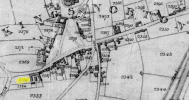
I don't know why I didn't think of this before... I just looked up the 1836-1843 Tithe records for Kings Norton on The Genealogist, which shows this:
1741280967113.png

On the tithe map that's here:
1741281110695.png

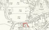
So while it was on "The Green" meaning the road, it wasn't on the actual triangle of green grass which is what I had assumed when Peter Higginbotham noted it as "on the south side of the Green". If I overlay the 1840ish map over a modern one, it was located where there is today a little cul-se-sac leading to numbers 31-36.
1741281372915.png

I hope this helps anyone searching for the exact location as I was.
 
On the 1st map it says 2333...nowadays this is Kings Green Ave. I lived at the end and my garden border was the old wall of the Workhouse.........also....the soil here was perfect loam.You could grow anything in it.
 
Back
Top