• Welcome to this forum . We are a worldwide group with a common interest in Birmingham and its history. While here, please follow a few simple rules. We ask that you respect other members, thank those who have helped you and please keep your contributions on-topic with the thread.

    We do hope you enjoy your visit. BHF Admin Team

King Edward's School, New Street 1838 - 1936

Going back to the original thread and the start of this post ...........
I have found a lot of material and photographs of the inside of the school ...
All dated from between 1883 till 1925 all are original photographs of the inside of the school......of no use to me as I am having a sort out
I could post but their is a lot of material
I should say that all this material was left to me in a will.
Best post can have the lot
 
Great to hear from you again, Cromwell. (I've been missing you!) And it's nice to learn that you have further pictures.

If you would like to share these KE images I should be more than happy to insert them on the website page which I have produced for this thread. In theory that should make them accessible for a time, for the benefit of anyone in the future who has an interest in the school and the building.

If you find this a reasonable and acceptable suggestion, could you scan and email some/all please?

Chris
 
I found an old photo of Stephenson Street (off Stephenson Place) on D J Norton's site, taken by Leonard Stace https://www.photobydjnorton.com/PhotosByLeonardStace.html
It shows the Queen's Hotel on the right hand side with a lot of cars parked outside...two or three Zephyrs are visible and a Rolls Royce. I remember some of the shops from later years when I worked at New Street Station. Thorton's Chocolate Cabin and a Freeman, Hardy & Willis shoe shop that I window shopped in many times.

In Stephenson Place on Leonard Stace's photo there is an M&B pub called
The Exchange. It is, of course, in The Exchange Building. I bet it was well used since there were some small convention type facilities in the Exchange Building and reps would come by train to these exhibitions of merchandise, etc. and more than likely met up in the pub. Curious as I was ,I remember walking into one of these events in my school uniform and had a look around. No one paid the slightest attention to me.

I don't remember a restaurant in Stephenson Place but as you say there
must have been one. I can imagine the menu being very limited back then.
Do you think the Exchange pub had a restaurant next to it or even in it Chris?

The story about the Slide Rule and Machinery Book is great. 88/- was a huge amount to pay for a book in those days Rupert. You certainly have had your money's worth out of it as you still have the book today.
There must be millions of slide rules gathering dust all over the world these days. We have a small morgue of graphic designer's "antique" tools in our house. Pencil sharpeners, ruby lith cutout knives, drafting and light tables, etc The PMT camera went to the dump years ago. Designing in 3D is where it's at now it seems and for any client anywhere also via computer.

Re. the traffic on New Street. It seems as the years went by into the late l950's and early 60's the traffic was horrendous on New Street and Corporation Street. Removing the traffic from New Street made sense to me, however, as you say Rupert it has changed the area a lot.
 
Do you think the Exchange pub had a restaurant next to it or even in it Chris?
Yes, Jenny, I think it must have had and it may well have been part of the pub. I don't remember anything about the latter but the restaurant was a respectable sort of place with linen tableclothes and decent cutlery and was, I am almost sure, upstairs. Perhaps there was even a separate entrance. My father always called it "The Exchange". (I always used to have whiting, which I knew I would be able to eat and wouldn't get into trouble for just picking at - now THERE'S a useful bit of information!)

Chris
 
One thing I have noticed here is that there are, once again, trees in Stephenson Place now, after a gap of some years. The old 1890 Ordnance Survey maps show trees there.
 
Just going back up the street for a moment, and round the corner to the right into New Street, you may like to have a look at some excellent further pictures of the school building, exterior and interior, generously provided by Cromwell.

After that, back into Stephenson Place, everyone!

Chris
 
The earlier pictures do not show towers; perhaps they were a later addition. It's loss is regretable but visualising it's location, it's future usage and upkeep must have been a quandry for planners. It sat on expensive acreage in what had become strange surroundings for a large school I think. Strange also to think that the old derelict roofless fish market,located just below it, outlived it by many years and the tall round modern tower (can't think of it's name at the moment) just to east of it, is probably a heritage building now. Where that assembly hall had been, maybe, Ella Fitzgerrald performed for us in the Odeon cinema. 'The Robe' was projected onto the large screen there. It's the whole thing really, and most of us were not born when the old building was around. It's the moat and the Manor House history and the double decker Midland Reds, turning the corner and parking in front of the railings and trees and St Martins, before turning down again along Jamaica Row. The hill and the cobbles and barrows and barrow boys and Nelsons statue. I can smell the fish market on the way down to old Woolworths. Curios, after all the years of seperation. From the comments in those old newspapers though, under the pictures, maybe there were bad feelings about the destruction at the time.
 
Yes John I am just visualizing a trip to the Odeon. After alighting from the tram in Martineau Street one would have walked along Union Passage down to New Street where a left turn would have been made. Yes the cinema would have been closer to the old Worcester Street and Albion Hotel. Funny, I can't remember Worcester Street being there at all. I suppose the Odeon would have been to the left of where the school was, facing it,but not far.
 
This is the area you are talking about, Rupert, mapped in a 1938 publication and little changed for another 20-plus years presumably, apart from the Luftwaffe's attentions.

The school is not shown, and the cinema is. One could argue that this indicates that the cinema was built on part of the old school site. On the other hand, a 1938 Edition map would presumably have been prepared in late 1937. If it shows developments on a site which was still being demolished in the first half of 1936, both the developers and the map revisers must have worked PDQ.

It would be interesting to know what the programme, and form, of the development of the school site were. The replacement building was certainly there by the outbreak of war and (I assume) was later replaced itself by the current building. (Or is what's there, behind a tarted-up facade, still the 1930s building? Surely not - but I can't conveniently take a look to check).

Chris
 
My uncle, Cyril Sharp, taught there as a PE instructor when he came out of the army after WW1.
Janet H
 
Peter Walker commented in a parallel thread "City Centre Photo Album" about some images on a website page about the school. I quote:

It is especially interesting to see the architect's original design, but it does not shows the two? towers which had to be demolished in 1936.
I just wonder about the two smaller exterior photos which are side by side. The detailing and especially the parapets do not quite match the other views and drawings, even the demolition pictures. It rather looks to me as if the facework was of terra cotta rather than natural stone - perhaps the photos were of the General Hospital or the Law Courts.​

I know little about the history of this building apart from the fact that it was built in about 1838 and then demolished in 1936. But Peter's comments raise some interesting questions.

Even allowing for artist's or engraver's licence it does appear that the buildings photographed in the early 20th century were very different from those shown in the early engravings. The latter indicate a "stand-alone" building, with a central entrance and no towers. The photographs suggest the appearance of a number of later buildings, located to the left of the original when one faces it from New Street, and possibly to an extent behind. It looks therefore as though the original building was extended at some stage in the 19th century into a much larger complex. This included the creation of a new main entrance whose location in relation to the original building is quite clear. It also looks as though the towers, clearly regarded as a Birmingham landmark, were part of this later addition. All this would of course explain the change in building materials and the appearance of terracotta, as used in other contemporary major buildings.

Perhaps the existence of these newer, less highly regarded buildings might explain the abandon with which this site was later redeveloped and the way that the merits of the original building at its core were ignored.

Chris
 
I have now discovered the reason for the discrepancy amongst the images which Peter pointed out. As we suspected, the buildings to the left of the original and the towers are the result of an 1890s development when the Girls' School was erected on the adjacent Hen and Chickens Hotel site.

Some of the images on my website page showed the later development rather than Barry's original. I have tidied it up to reflect this additional information and also to include further interesting images, generously provided by forum members, showing the building in 1905 and the late 1920s.

Chris
 
Last edited:
I have been given some additional interesting information about the invasion of girls into the hallowed, all-male surroundings of Barry's building. It is now included on the website page for which I gave the link in the previous post.

Chris
 
Hi Chris: Had a good look at your website re the Grammar School on New Street. The site is excellent and such an important piece of Birmingham history. Thanks for the research and hard work putting this together.
 
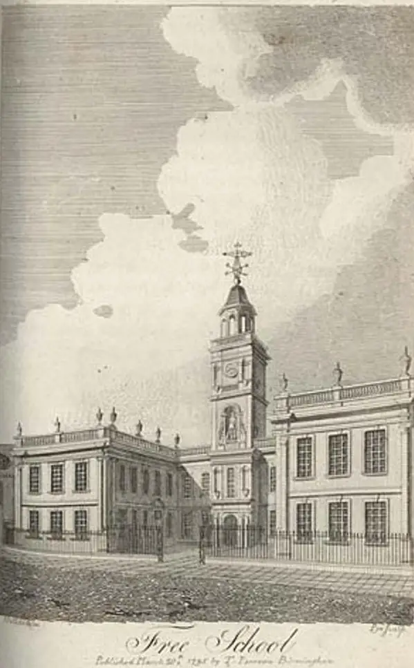
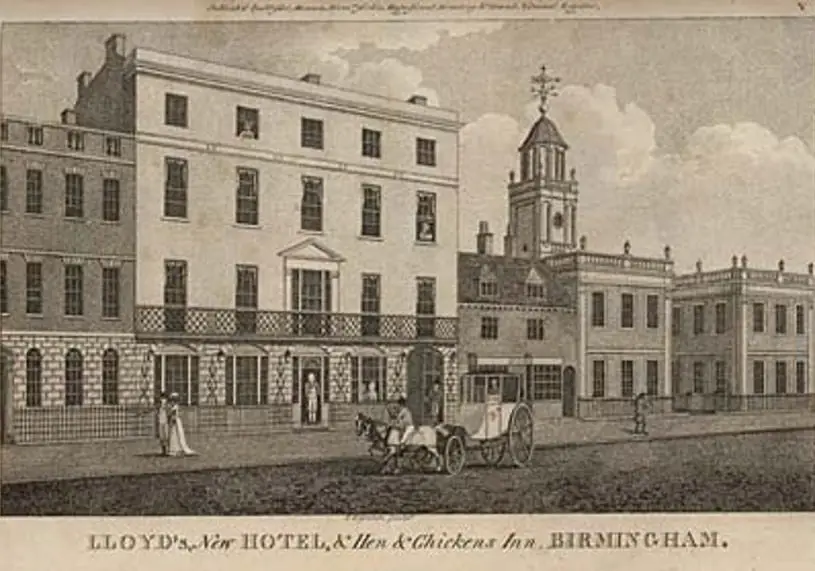
A couple of engravings to add to this thread (can't tell if these were on here before the hacking). Two nice views of the school (pre-Barry, gothic building) in New Street. The first is 1780 and the second is 1808. Viv.


Free_School_1780.jpg

Lloyds_Hotel___Hen___Chickens_1808.jpg
 
Thanks for those, Viv. They are great pictures. I don't recall seeing them before within this thread. Most of the images here were reproduced on my website page dealing with this subject and so I have not reinstated those of them which I posted originally.

Chris
 
I've looked at your web page Chris and it's incredibly interesting. Some excellent photos on there, especially of the interior. I took the liberty of posting the link to your page on the "Birmingham Exchange Buildings" thread, as we were discussing how that stretch of New St developed. Rupert raised some interesting points about the relationship to the Guild of the Holy Cross on there. Thanks. Viv.
 
Last edited by a moderator:
The Free School (pre-Charles Barry building) was obviously a very important and impressive building in 1731 as it actually appeared on Westley's map of that time - lower left on New Street. Viv.

New_Street_Westley_s_1731.JPG
 
I like this map, I have often meant to find out where The Froggary was! (Sorry I'm off topic).
Thanks Vivienne.
rosie.
 
img027~0.jpg
9
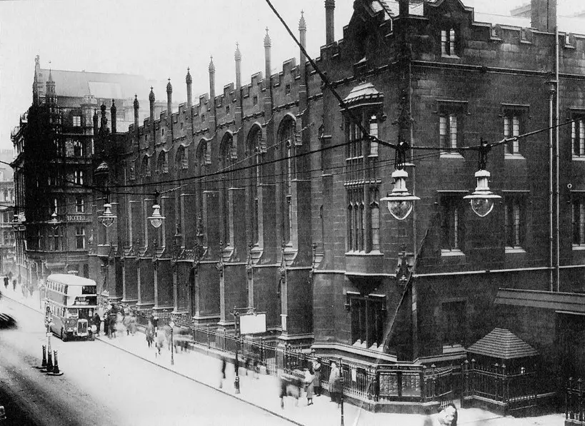
Hello Chris, this picture is only slightly different to one you already have but as you can see I have posted it anyway. The information with it tells us that the photo is from 1934 which was a year before it moved to Edgbaston, and final demolition took place in 1937.
 
Thanks for that, Stitcher. Interesting. The bus could be the same one. The people have moved. I wonder if the two images (this one and the one on my website page) were in the same sequence, taken from a slightly different angle, a few moments apart.

Thanks also for the map, Vivienne. Should like to incorporate it on my page in due course, if you have no objection.

Chris
 
Last edited:
Chris I'll dig out the proper title of the map for you - it's Westley's 1731, but will look up the full title and post it here. Viv.
 
Chris that map extract was from "The Plan of Birmingham Surveyed in the Year 1731 by W. Westley" Viv.
 
img457.jpg
This is from another angle and it says 1934, when this building was demolished the Paramount Cinema was built on part of the site. The Paramount opened in 1937 and after the war it was changed to The Odeon.
 
This link contains some short films about KE. 'New Street Remembered' has interviews with former 'Old Edwardians' and interior shots of the New Street school. The film was made for viewing with 3D glasses, but I watched it without and it seems ok. The David Blissett film is also worth watching. Viv.

https://www.oldeds.kes.org.uk/ns-film.html

And here's a nice view of the earlier KE school from the Blissett film. Sorry don't know the date.

560791fc-ba7a-9467.jpg
 
Some sketches by Samuel Lines Snr of views not usually seen. D686B15A-A002-46F6-9BC7-E1302A1D195B.jpeg
A sketch of the old schoolroom at the Free school by Samuel Lines Snr in 1820
4578CC65-F77D-4784-BCA3-B1AC1408E8AF.jpeg
Pencil drawing from the garden of King Edwards School by Samuel Lines Snr

CE5B4C3A-025B-46A8-8513-19D702350A51.jpeg
Drawing from the garden of King Edwards School by Samuel Lines Snr

Viv.
 
Back
Top