S
-
Welcome to this forum . We are a worldwide group with a common interest in Birmingham and its history. While here, please follow a few simple rules. We ask that you respect other members, thank those who have helped you and please keep your contributions on-topic with the thread.
We do hope you enjoy your visit. BHF Admin Team
You are using an out of date browser. It may not display this or other websites correctly.
You should upgrade or use an alternative browser.
You should upgrade or use an alternative browser.
Just Outside Birmingham by Post Card.
- Thread starter motorman-mike
- Start date
I think the mill buildings are right opposite Warwickshire Cricket Ground on Edgbaston Road. The buildings can be seen on the old 1890 survey map and the mill is named Edgbaston Mill House. There seems to be a lane leading to it and maybe that was called Edgbaston Lane although by convention these lanes are usually called just Mill Lane. The Rea seems to have been divided by wiers there with the original course to the west of the cricket ground but now the river seems to have been all diverted to the east of the ground and the old run abandonned. I have posted the map link for ease of reference and if you Google Earth it you will be able to see the foundation outline of the buildings(I think) but that is all. This may have been covered on the mills of Birmiinham thread but I can't remember it. I think that some of the old river run can be seen and followed a bit by the tree lines. I watched M.J.K. Smith and Swaranjit Singh and Kenny..Ossie et al. play there a few times. Seems like a totally different world now...not better though.
https://www.british-history.ac.uk/m...id=10106&ox=869&oy=237&zm=1&czm=1&x=272&y=408
https://www.british-history.ac.uk/m...id=10106&ox=869&oy=237&zm=1&czm=1&x=272&y=408
S
Stitcher
Guest
That is fascinating rupert, thanks a lot.
Rupert
I don't know if you've downloaded the latest version of google earth, but, if you do then you can go back from the current image (2007) to the image in 1999. Here not so much work has been carried out, and where the mill was seems to be a square of trees
mike
I don't know if you've downloaded the latest version of google earth, but, if you do then you can go back from the current image (2007) to the image in 1999. Here not so much work has been carried out, and where the mill was seems to be a square of trees
mike
rupert
If its the latest edition there should be a little clock in the middle of the symbols at the top of the page, and if you click this ,then you get a sliding bar to alter the picture.Antway here is the view you get. I'm not so keeen on the angled view I can't seem to turn off.
mike
If its the latest edition there should be a little clock in the middle of the symbols at the top of the page, and if you click this ,then you get a sliding bar to alter the picture.Antway here is the view you get. I'm not so keeen on the angled view I can't seem to turn off.
mike
Arkrite
master brummie
Mikejee, I to dislike the tilted view. Try this on Google Earth. Tools > GE Options > Navigation tab > navigation box unclick Auto Tilt while Zooming.
Afterwards go to the TOURING tab and set the Camera Tilt angle slider to the extreme left.. click apply where needed. It Works for me. Cheers.....Arkrite
Afterwards go to the TOURING tab and set the Camera Tilt angle slider to the extreme left.. click apply where needed. It Works for me. Cheers.....Arkrite
S
Stitcher
Guest
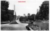
The Agriculture Show at Four oaks in 1898. This event was held close to the railway station.
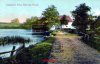
Can't download the b.map picture from G.E. Anyway if you go to Solihull High Street and click on the little blue photo square just NW of the junction with Drury, you will see the present day view of the old photo on post #105. Also Mill Lane used to lead to Olton Mill and it can be followed there on the 1890 survey but Mill Lane seems to end in the town now. However just go north and you will be able to see the old mill pool still there but the mill buildings are gone now. It's on Lode Lane close to Ratcliffe Drive.
I don't seem to have the clock. It says that you have to subscribe. Love these old pictures.
I don't seem to have the clock. It says that you have to subscribe. Love these old pictures.
That's peculiar rupert. At https://earth.google.com/ at the top of the page , to me, it gives a link to the free download, unless the US is making it awkward for canada again.
mike
mike
S
Stitcher
Guest
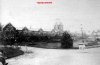
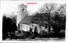
I have had to do a lot of restoration work on this picture because it is on flimsy paper and was rather creased up. Again it was with several others and is supposedly from somewhere near Sutton Coldfield.
Around the end of the 17th century, Sir William Wilson designed Four Oaks Hall. He was commisioned for the work by Lord Ffolliot who was an Irish peer. The Hall had alteration work carried out by Simon Luttrell just prior to this picture. Sadly the hall was demolished in 1898.
Around the end of the 17th century, Sir William Wilson designed Four Oaks Hall. He was commisioned for the work by Lord Ffolliot who was an Irish peer. The Hall had alteration work carried out by Simon Luttrell just prior to this picture. Sadly the hall was demolished in 1898.
Attachments
![four oaks hall[1].jpg](/forum/data/attachments/24/24625-b21af25a6b2d51b69d53b9270ef7eb04.jpg?hash=shryWmstUb)
Last edited by a moderator:
motorman-mike
Brum visitor who stayed.
S
Stitcher
Guest
S
Stitcher
Guest
Thanks Dave.
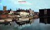
Here is the mill on the 1890 survey
https://www.british-history.ac.uk/m...d=8806&ox=3398&oy=3116&zm=1&czm=1&x=471&y=418
https://www.british-history.ac.uk/m...d=8806&ox=3398&oy=3116&zm=1&czm=1&x=471&y=418
S
Stitcher
Guest
Rupert, thanks again for taking the time to furnish some more information. When I see the location of a picture in relation to todays image of the same area, it somehow adds a bit of meaning to it all, if you can understand what I mean.
I used to fly my model aeroplanes on the hill in the background. There were so many old water mills in the midlands area that, if you stuck a pin in every location, you would have a sea of yellow on your GE screen. Pretty much any pond is suspect and you can still see the outline of filled in ones. In this instance the pond is still there and although the buildings seem to have gone the little area is pretty much as it was 150 years ago. You can still pick out the Roman Road Ryknield Street just to the NW of the pool on GE and it is marked on the old map.
Making a mill pool in that location would have consisted of building a dam on the small stream there and allowing the water to back up. I suspect that the pool is a shallow one on the whole and using the natural topography makes it rather large for a pool. I don't know what the head is but you might be able to get some idea by visiting the road that runs over the dam now. The mill simply sat on the dam; the spindle basement somewhat sunk by an amount depending upon weather it was overshot or undershot or breast shot.
Making a mill pool in that location would have consisted of building a dam on the small stream there and allowing the water to back up. I suspect that the pool is a shallow one on the whole and using the natural topography makes it rather large for a pool. I don't know what the head is but you might be able to get some idea by visiting the road that runs over the dam now. The mill simply sat on the dam; the spindle basement somewhat sunk by an amount depending upon weather it was overshot or undershot or breast shot.
S
Stitcher
Guest
Rupert, you and some of the others never cease to amaze me, if it's not you and pmc with places its Lloyd, M.Mike and John70 with buses and trams. I hope I speak for others when I say we are lucky to have such knowledgeable people on the forum.
S
Stitcher
Guest

S
Stitcher
Guest
I don't know what you mean. Haa Haa
Guys Cliffe mill is north of Warwick on the Avon west of Milverton. I have seen a picture on Windows on Warwickshire site.
https://www.search.windowsonwarwickshire.org.uk/engine/resource/default.asp?theme=123&originator=%2Fengine%2Ftheme%2Fdefault%2Easp&page=4&records=132&direction=2&pointer=9033&text=0&resource=23192
Here is the 1890 ref.
https://www.british-history.ac.uk/m...heetid=8891&ox=0&oy=0&zm=1&czm=10&x=453&y=411
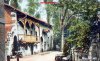
I don't know how the hydraulics worked on this one. There seems to be a leat from the Avon in addition to the river running by it. The ornate balcony would be a fitting stage for Romeo and Juliet I think. Anyway this place looks like a wonderful days outing in the summer. There is a building still which now appears to be a pub and restaurant and just down stream there are the ruins of Guys Cliffe which appears to have been an Abby or such. It looks very nice.
Maybe the leat was to reduce the flow and pressure on the mill when there was flooding. Maybe they could have opened a floodgate to let excess water down to the lower area below the weir.
There are some great pictures on GE of this spot and the ruins below.
https://www.search.windowsonwarwickshire.org.uk/engine/resource/default.asp?theme=123&originator=%2Fengine%2Ftheme%2Fdefault%2Easp&page=4&records=132&direction=2&pointer=9033&text=0&resource=23192
Here is the 1890 ref.
https://www.british-history.ac.uk/m...heetid=8891&ox=0&oy=0&zm=1&czm=10&x=453&y=411
I don't know how the hydraulics worked on this one. There seems to be a leat from the Avon in addition to the river running by it. The ornate balcony would be a fitting stage for Romeo and Juliet I think. Anyway this place looks like a wonderful days outing in the summer. There is a building still which now appears to be a pub and restaurant and just down stream there are the ruins of Guys Cliffe which appears to have been an Abby or such. It looks very nice.
Maybe the leat was to reduce the flow and pressure on the mill when there was flooding. Maybe they could have opened a floodgate to let excess water down to the lower area below the weir.
There are some great pictures on GE of this spot and the ruins below.