-
Welcome to this forum . We are a worldwide group with a common interest in Birmingham and its history. While here, please follow a few simple rules. We ask that you respect other members, thank those who have helped you and please keep your contributions on-topic with the thread.
We do hope you enjoy your visit. BHF Admin Team
You are using an out of date browser. It may not display this or other websites correctly.
You should upgrade or use an alternative browser.
You should upgrade or use an alternative browser.
Hockley Brook floods
- Thread starter Astoness
- Start date


lol barrie...how fascinating that must have been...
mabz..same here...i took a peep going to farm st school and another on the way back...by the way.it still pongs as bad as ever it did...
dad used to live in hunters vale but due to the floodings some years before i think the houses got into a really bad condition so they moved just round the corner to villa st....
lyn")
mabz..same here...i took a peep going to farm st school and another on the way back...by the way.it still pongs as bad as ever it did...
dad used to live in hunters vale but due to the floodings some years before i think the houses got into a really bad condition so they moved just round the corner to villa st....
lyn
Last edited by a moderator:
just following up on the brook...here is an old pic of hunters vale during the floods i think it was in 1918...also a map..if you follow the dotted line thats where it flowed....
lyn
(Replacement)
lyn
(Replacement)
Attachments
Last edited by a moderator:
terryb18
Gone but not forgotten R.I.P.
barrie
master brummie
Thats a great link to an interesting site, thank you for posting it Terry. As I said previously, after heavy rain it got quite noisy in our back kitchen, not surprising considering what the author of that article found in the brook.
Mayfield
Burbury Brummie
mabz..looks like we followed the brook around..id forgotton it also touched paddington st where i was born....you would know this better but dosnt it go though defford road....looks pretty close...
lyn
Yes Lyn - it was underground and crossed the top of Defford Road on its way through to Burbury Park
A link to above and below ground images of Hockley Brook: https://www.28dayslater.co.uk/baptiser-moonwalker-birmingham-feb-2010.t47296
Peg Monkey
master brummie
I was born in Heaton St, a few minutes walk from Hockley Brook, and lived there until I was 10 (1959); the other day I set myself the task of finding out where Hockley Brook rises and outfalls and used Astoness Lyn's mapsite:
https://maps.nls.uk/geo/explore/#zoom=18&lat=52.4959&lon=-1.9081&layers=176&b=6
Sadly I ran out of fried egg sandwiches (a delicacy I had a particular taste for as a pupil at Harry Lucas School, partly because they were cheap (1/-, 5p in new money) usually procured from a cafe in Farm St) before completing the task.
I'm guessing the Brook must rise very near Hockley, somewhere (otherwise it would not be called Hockley Brook), as for the outfall I'm guessing the Tame.
Can anyone throw light on this important topic?
Peg.
https://birminghamhistory.co.uk/forum/index.php?threads/peg-monkey-cartoons.48101/page-4#post-618593
Must View!:
https://birminghamhistory.co.uk/forum/index.php?threads/peg-monkey-cartoons.48101/#post-599477
Last edited:
Radiorails
master brummie
Peg Monkey
master brummie
Fantastic, Alan. Thanks.
Peg.
Peg.
It rises in Smethwick, Its also known in parts of Aston, as Aston BrookI was born in Heaton St, a few minutes walk from Hockley Brook, and lived there until I was 10 (1959); the other day I set myself the task of finding out where Hockley Brook rises and outfalls and used Astoness Lyn's mapsite:
https://maps.nls.uk/geo/explore/#zoom=18&lat=52.4959&lon=-1.9081&layers=176&b=6
Sadly I ran out of fried egg sandwiches (a delicacy I had a particular taste for as a pupil at Harry Lucas School, partly because they were cheap (1/-, 5p in new money) usually procured from a cafe in Farm St) before completing the task.
I'm guessing the Brook must rise very near Hockley, somewhere (otherwise it would not be called Hockley Brook), as for the outfall I'm guessing the Tame.
Can anyone throw light on this important topic?
Peg.
https://birminghamhistory.co.uk/forum/index.php?threads/peg-monkey-cartoons.48101/page-4#post-618593
Just Google Hockley Brook and save on Egg sandwiches LOL
https://en.wikipedia.org/wiki/Hockley_Brook
https://en.wikipedia.org/wiki/Hockley_Brook
Peg Monkey
master brummie
Thanks, Bill. Welcome to the forum. Seems like Smethwick Brook would have been more appropriate.It rises in Smethwick, Its also known in parts of Aston, as Aston Brook
Peg.

Bob Davis
Bob Davis
Interesting that on another thread there has been discussion about m/cycle sidecars and there are two in this postcardA new one on me.View attachment 128520
Bob
Agree, the Palladium would be on the left hand side just back a bitIt looks circa 1920s and the view is towards the city.
I maybe wrong here, but if the photographer is facing town whilst standing on Hockley Brook, then surely The Palladium would have been quite a way behind him ?Agree, the Palladium would be on the left hand side just back a bit
I maybe wrong here, but if the photographer is facing town whilst standing on Hockley Brook, then surely The Palladium would have been quite a way behind him ?
The blue line shows the Palladium and you can see the top of the 'upside down saucer top' with the spire on here which is just down from the Palladium as shown on the Hockley Brook picture. So not far away really.

Radiorails
master brummie
Post 63# of this thread shows a little of what, presumably, is the Palladium. As the photo in the previous posts suggests it is Soho Hill.
https://birminghamhistory.co.uk/forum/index.php?threads/soho-hill.30039/page-4
https://birminghamhistory.co.uk/forum/index.php?threads/soho-hill.30039/page-4
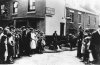
Hockley Brook - no date given with this one. Viv.

mw0njm.
A Brummie Dude
i have already posted some were on this forum with ger22van. about the brook. i used to work for bryants when they done the new sewer in aston brook st. the brook ran along side it .the brook was huge in parts we would walk it first with road lamps then with big lights. if it started to rain run and get out. thanks radiorails for latest pics
Last edited: