-
Welcome to this forum . We are a worldwide group with a common interest in Birmingham and its history. While here, please follow a few simple rules. We ask that you respect other members, thank those who have helped you and please keep your contributions on-topic with the thread.
We do hope you enjoy your visit. BHF Admin Team
You are using an out of date browser. It may not display this or other websites correctly.
You should upgrade or use an alternative browser.
You should upgrade or use an alternative browser.

Pedrocut
Master Barmmie
This may account for the name change...
“From 1869, Aston Manor was governed by Aston Manor Local Board. It became an Urban District in 1903 and was finally absorbed into Birmingham in 1911.”
“From 1869, Aston Manor was governed by Aston Manor Local Board. It became an Urban District in 1903 and was finally absorbed into Birmingham in 1911.”
There’s this one Lyn. Viv.


And the listing details

 historicengland.org.uk
And the listing details
HIGHCROFT HOSPITAL, MAIN BUILDING, Non Civil Parish - 1351967 | Historic England
List entry 1351967. Grade II Listed Building: Highcroft Hospital, Main Building. May include summary, reasons for designation and history.
Last edited:
There is anotger thread about the Aston Union/Highcroft including this one from the Peter Walker Archives. Viv.
 birminghamhistory.co.uk
Birmingham Workhouse -peter Walker
Origin of the first Workhouse of 1734 During the 18th century, as towns grew and more people moved from farm work, the care of the elderly, infirm, for widows and orphans, who otherwise had no means of support, became an increasing problem for parish councils. Parliamentary Acts were passed to...
Last edited:
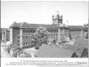
Here are some items from"Highcroft from workhouse to modern mental health service", pub by the highcroft history Group, Ed byMike Hinson,
Some views of the hospital, including a better copy of Vivs aerial view


Here is an artists impression of the previous Erdington workhouse, which had faced Erdington village Green

A guide plan from1939 of Erdington /house, which was what it was named 1912-1942 (I have joined two pages and twisted map so it is north-south as previous maps)

~And finally, in case i is of interest, a listing of the wards and their use in 1914

Some views of the hospital, including a better copy of Vivs aerial view
Here is an artists impression of the previous Erdington workhouse, which had faced Erdington village Green
A guide plan from1939 of Erdington /house, which was what it was named 1912-1942 (I have joined two pages and twisted map so it is north-south as previous maps)
~And finally, in case i is of interest, a listing of the wards and their use in 1914
Last edited:
pjmburns
master brummie
Photos and info on Aston Union workhouse here http://www.workhouses.org.uk/Aston/
pjmburns
master brummie
The caption refers to "the giant water tower" - apparently a feature of many workhouses and hospitals built at that time. I am not sure it means it had to be a well.On Photo 4 I think the artesian well can be seen on the extreme middle right ??
On Photo 4 I think the artesian well can be seen on the extreme middle right ??
i can see what looks like a circle of bricks on the ground middle of the photo not sure what that would be though
lyn
Perhaps the well was located near to the wash house/laundry etc. Viv.

pjmburns
master brummie
That is a possibility. In one article I read it suggested many such premises were built with water towers. I do not think they would all have artesian wells.
If it was artesian it could have been in a basement (as in at least one brewery in Birmingham) and so might not show on maps or plans, only on internal plans.
If it was artesian it could have been in a basement (as in at least one brewery in Birmingham) and so might not show on maps or plans, only on internal plans.
For info, this building was the Bell Lane location - road is now called Orphanage Road. It was where the later Erdington Library was built. Viv.

Have merged three former Aston Union Workhouse threads. So there might be a few snippets of use contained in the merged thread below. (Not had chance to read through entirely yet). Viv.
birminghamhistory.co.uk
Aston Union Workhouse
I discovered that my great uncle's daughter died in that work house, in April, 1917, she didnt even make her second birthday, tragedy of it is that her dad was away on active service, I am wondering how a heavily pregnant mother and a child would have been in a workhouse. The little girl's name...
pjmburns
master brummie
On 1904 map Highcroft Road is labelled Union Road - presumably after Union Workhouse. It is Union Road on 1920 map but Highcroft Road by 1937 map - nothing online in between.Luckcocks Lane could be what is now Highcroft Road. In the Lane in 1876 there was a Mere Cottage, and on the 1880s map there is a Mere House.
Last edited:
Pedrocut
Master Barmmie
In 1844 a sensation at Erdington, when a man attempted to murder his daughter, Luckcocks Lane within a mile of Erdington. He struck her on the head and cut her throat. She was removed to the Queen's Head, and the man found in
Slade Road and taken to the Erdington lock-up. Overnight he strangled himself, and after the inquest it was said that the girl was out of danger.
Slade Road and taken to the Erdington lock-up. Overnight he strangled himself, and after the inquest it was said that the girl was out of danger.

Pedrocut
Master Barmmie
Lyn - can't find a well but the map in #6 shows a "P" and this could indicate the site of a pump to raise water from the well into storage tanks. There is a description of something similar at the Birmingham Union Workhouse'
View attachment 152467
The key for the old map does show P used for pump.
Lyn - can't find a well but the map in #6 shows a "P" and this could indicate the site of a pump to raise water from the well into storage tanks. There is a description of something similar at the Birmingham Union Workhouse'
View attachment 152467
great jan i did look at that but didnt connect it to a well...i wonder if it possible to pin point in today world the exact spot
lyn
Very tricky as I think that part of the building has long gone. I did check basement plans on 2003 conversion planning application but no well and, of course, only main building survives. Laptop off at minute will look later unless someone beats me to it.
thanks jan im a tad busy for the next couple of days so anything you find would be good
lyn