-
Welcome to this forum . We are a worldwide group with a common interest in Birmingham and its history. While here, please follow a few simple rules. We ask that you respect other members, thank those who have helped you and please keep your contributions on-topic with the thread.
We do hope you enjoy your visit. BHF Admin Team
You are using an out of date browser. It may not display this or other websites correctly.
You should upgrade or use an alternative browser.
You should upgrade or use an alternative browser.
Hall Green
- Thread starter Vivienne14
- Start date


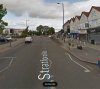


The Hamlets. The first image is dated 1910. Viv.


From Wikipedia - private development, "The Hamlet" built between 1883 and 1893, consisting of villas on Hamlet and Fox Hollies Roads, along with the Friends Meeting House on the Stratford Road. Brick and tile properties with massive chimneys and timbers, leaded casements, and bracketed bays. All the properties probably bore the initials 'MS' and date of construction - few plaques are left. The monogram might refer to Marian Severne whose families land they were built on.
From Wikipedia - private development, "The Hamlet" built between 1883 and 1893, consisting of villas on Hamlet and Fox Hollies Roads, along with the Friends Meeting House on the Stratford Road. Brick and tile properties with massive chimneys and timbers, leaded casements, and bracketed bays. All the properties probably bore the initials 'MS' and date of construction - few plaques are left. The monogram might refer to Marian Severne whose families land they were built on.
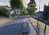
Highfield Road, much like a boulevard, very leafy, with a large central reservation. Looks very similar today. Viv.

The road in 1912.

The road in 1912.
farmerdave
master brummie
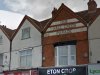
Hall Green Parade in 1987 looking away from town with Cubley Road on the right. Skidmore's the butchers is still there (I remember them from the 1950s and 60s). They have the second set of roller blinds from the left. Next to them and away from us is Paynes shoe repairs, followed by Threshers (wine?) and Kates, which I think was a cake/coffee shop. Dave.
.JPG")
Radiorails
master brummie
Presumably, if it can be proven that warning signs were ignored it is more than likely that your insurance would be void.
Last edited:

Radiorails
master brummie
Paddled there are few times and cleaned my bicycle. ")


A Sparks
master brummie
Looks like a pig to me toomike do i need to go to spec savers...what is that hanging outside the post office..looks like a giant pig to me...i can even see 2 ears
lyn

glad its not just me sparks...and why would the 2 men be wearing aprons to work in a post officeLooks like a pig to me too
lyn
and maybe mike that was the farmer delivering the prize in his horse and carti agree it looks like a pig. Perhaps the post office won it in a raffle
lyn
farmerdave
master brummie
The photograph of the post office with the pig is also shown in Images of England, Hall Green compiled by Michael Byrne, page 19. QUOTE "From 1898 the directories show Caleb Cox now running the post office, with butchers and grocers businesses added". UNQUOTE.
thanks dave that explains the pig hanging upThe photograph of the post office with the pig is also shown in Images of England, Hall Green compiled by Michael Byrne, page 19. QUOTE "From 1898 the directories show Caleb Cox now running the post office, with butchers and grocers businesses added". UNQUOTE.
lyn
pjmburns
master brummie
According to the book referenced in post #19.
Church Lane was the name (until around 1910) of the section of Fox Hollies Road from the Church to Stratford Road. Between 1910 and 1914 it was Church Road and then became Fox Hollies Road.
(It seems to be on 1901 census as Church Road).
Church Lane was the name (until around 1910) of the section of Fox Hollies Road from the Church to Stratford Road. Between 1910 and 1914 it was Church Road and then became Fox Hollies Road.
(It seems to be on 1901 census as Church Road).
The 1904 and 1908 directories list the houses between the Bulls Head (Stratford Road) and the Church of the Ascension (Hall Green Parish Church) as Church Lane and include York House on what became School Road. The 1912 directory omits York House but calls the stretch of road Church Road.According to the book referenced in post #19.
Church Lane was the name (until around 1910) of the section of Fox Hollies Road from the Church to Stratford Road. Between 1910 and 1914 it was Church Road and then became Fox Hollies Road.
(It seems to be on 1901 census as Church Road).

BrummieGeoff
Sparkhill Lad
The building is Cateswell House ..... shown near the bottom left corner of this aerial view dated 16 June 1952.

Some history - and a fair bit of speculation !
Hall Green Hall was originally Hawe Hall, its early origins, like other local Halls, being masked by casing the timber frontage. It was demolished in the 1930s.
The church ("Marston Chapel ") that Job Marston made provision for before his death is now the Church of the Ascension, which still exists today at the junction of Fox Hollies Road and School Road.
Source: British Newspaper Archive
Last edited: