-
Welcome to this forum . We are a worldwide group with a common interest in Birmingham and its history. While here, please follow a few simple rules. We ask that you respect other members, thank those who have helped you and please keep your contributions on-topic with the thread.
We do hope you enjoy your visit. BHF Admin Team
You are using an out of date browser. It may not display this or other websites correctly.
You should upgrade or use an alternative browser.
You should upgrade or use an alternative browser.
Re: guilford street lozells
The photo post #141 is a great shot. Nice sunny morning by the look of it and the shadows, or lack of them in places, outline the roads entering Guildford from the right. I know that the photo is meaningful to those who lived in the area at the time for nostalgia reasons but although I was born not far away in Summer Lane, I was never on this street. The photo is of interest to me for what you can't see, rather than what you can. If the first road on the right, by the Van on the right, is Paddington then the next one further is Kensington and in between the two runs Hockley Brook. At the bottom of the terain. Not visible now because it is down maybe 15 or 20 feet in a bricked culvert, the same system visited by Virus Man from here I think. Any way, further up the hill just past Denmark Street would have been the mill pool for Aston Furnace, located just above Kensington at Porchester in the 1700/1800s. The pool was a longish widened leat that was dug from the Soho Road area I believe. This photo gives some idea of the head available at the water wheel that drove the furnace bellows. Possibly 20 feet approx by the look of it. All gone way before this photo of course but the brook is still down there. Back then this would have been a field and the Brook area a flood plain. There is another very old picture somewhere taken from the top of the huge mound of slag/cinders and looking at this street from about where the Alma Street school used to be and some three storied houses can be seen in that picture dated about 1850 maybe. I am not sure how old the buildings in the photo here are but they seem to be of different eras...probably not as old as 1850. Anyway this picture would make a good addition to the Aston Furnace thread also. Oh and maybe a moderator could add the 'd' to the thread name for indexing purposes.
Link https://www.british-history.ac.uk/m...d=10094&ox=1420&oy=679&zm=1&czm=1&x=325&y=155
Last edited:
Michael_Ingram
gone but not forgotten
Re: guilford street lozells
The first street on the right is Geach Street Rupert, then Paddington Street, etc.,
The first street on the right is Geach Street Rupert, then Paddington Street, etc.,
irene floyd
master brummie
Re: guilford street lozells
Lovely photo's has anyone got any of INKERMAN STREET NECHELLS?
Lovely photo's has anyone got any of INKERMAN STREET NECHELLS?
TOPSYTURVEY
brum
Re: guilford street lozells
#165 How interesting Rupert. According to that the brook would have ran under the back of our garden roughly when we lived in Paddington St.
#165 How interesting Rupert. According to that the brook would have ran under the back of our garden roughly when we lived in Paddington St.
Re: guilford street lozells
You can see the run of the brook on the link map. Follow the dots back from Porchester and Furnace Lane. They are not very clear but sure you will see them. The numbers on the map eg. BM345 or such, (Bench Mark) gives the elevation at that point and from this you can see aproximately how high the pool would have been above the brook at the Furnace. Actually if you watch the bottom numbers on Google Earth you can check the elevations against the OS map. I think you can still find the junction of Porchester and Funace Lane. I would have been a bit wary of having a body of water above my abode but suppose that when the leat and pool was constructed there would not have been any houses below it and when they started to appear the millpool and leat would have been filled in. Actually I think that the old picture from the top of the tip may show the start of the fill in if interpreted with a little intuition. I can't find the old picture ref. right now but maybe it will show up.
There is an Inkerman Street in Nechells and it is close to what used to be the beautiful 19th century Vauxhall Gardens...the subject of another thread. Inkerman Street in Newtown was built upon the levelled out slag/cinder mound.
link..https://www.british-history.ac.uk/m...etid=10099&ox=430&oy=216&zm=1&czm=1&x=73&y=56
Thats the river Rea in the map.
Last edited:
Michael_Ingram
gone but not forgotten
Re: guilford street lozells
I think this will help with the Brook although the resolution isn't good (It is an old image from the forum - I found it in the cave of lost Brummie Photos - a sneaky reference to Richard Brautigan - for those who remember)

I think this will help with the Brook although the resolution isn't good (It is an old image from the forum - I found it in the cave of lost Brummie Photos - a sneaky reference to Richard Brautigan - for those who remember)
Michael_Ingram
gone but not forgotten
Re: guilford street lozells
I've enanced it a bit

I've enanced it a bit
Michael_Ingram
gone but not forgotten
Re: guilford street lozells
Or a larger view here
https://www.flickr.com/photos/69596484@N06/6360233249/sizes/l/in/photostream/
Or a larger view here
https://www.flickr.com/photos/69596484@N06/6360233249/sizes/l/in/photostream/
TOPSYTURVEY
brum
Re: guilford street lozells
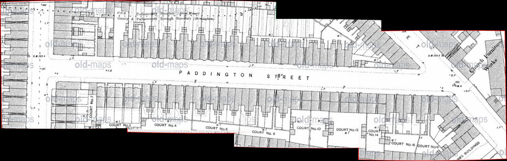
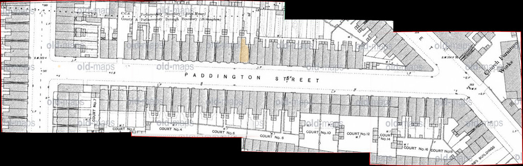
Would anyone know where 39 Padddington would have been on the map please that is where i lived.
Would anyone know where 39 Padddington would have been on the map please that is where i lived.
Re: guilford street lozells
Lyn
I think the red building is back of 12. It is from https://forum.birminghamhistory.co.uk/showthread.php?t=36656 , which I have now reposted, No 7 was the blue house on that thread. (Reason it is different from above is I later added blue house,)
Lyn
I think the red building is back of 12. It is from https://forum.birminghamhistory.co.uk/showthread.php?t=36656 , which I have now reposted, No 7 was the blue house on that thread. (Reason it is different from above is I later added blue house,)
TOPSYTURVEY
brum
Re: guilford street lozells
Thank you so much Mike for marking our house. Never knew we lived above The Brook. Lyn you only lived across the road then.
Thank you so much Mike for marking our house. Never knew we lived above The Brook. Lyn you only lived across the road then.
Michael_Ingram
gone but not forgotten
Re: guilford street lozells
Been searching through my archives and found three maps previously posted relating to Aston Brook (one similar to a recent one but a better resolution)


Been searching through my archives and found three maps previously posted relating to Aston Brook (one similar to a recent one but a better resolution)
TOPSYTURVEY
brum
Re: guilford street lozells

Michael_Ingram
gone but not forgotten
Re: guilford street lozells
I believe my mom and gran attended it when it was a chapel. I knew it as Cowdrill's factory. You could get your bike frame chromium plated there.
I believe my mom and gran attended it when it was a chapel. I knew it as Cowdrill's factory. You could get your bike frame chromium plated there.
Re: guilford street lozells
#187 map 4 is a good one. Oh it's all been on here before but there are new members now and a glance at the map will not reveal much. If you look just above the word Birmingham at the bottom you will see the word Bourne...that is Hockley brook named differently back then. Just above the word Bourne is what looks like another stream and that is the leat to Aston Furnace. The road branching up to the left is Soho Hill and the other fork here is Hunters Road (present names given) Follow the Bourne and the leat above it to the word pastures and where the 'P' is would be Guildford Road. Just to the right of the 'P' would be Aston Iron furnace and Furnace Lane and Porchester. The leat and the Brook carry on downstream to the right and meet up again just below a water mill called Aston Flour Mill (maybe not always flour). Anyway at about the letter 'A' in pastures. If you look up Pye's Travells you will find, if you have the patience to look, a trip he made along the Walsall to Birmingham Road and he mentions, as he went past the furnace at about the word 'and', the huge mound of cinders from the furnace. Huge...like see much of Brum from the top.
There is much more in this little map that has been discovered here but off topic.
Michael_Ingram
gone but not forgotten
Re: guilford street lozells
Thanks Rupert. I knew these had been posted before and was hoping someone would come up with more details. Great stuff
Thanks Rupert. I knew these had been posted before and was hoping someone would come up with more details. Great stuff
TOPSYTURVEY
brum
Re: guilford street lozells
From one of Carl Chinns books ,reminds me so much of when my mom/dad moved .

From one of Carl Chinns books ,reminds me so much of when my mom/dad moved .
TOPSYTURVEY
brum
Re: guilford street lozells
