Hi gang firstly may i say Wow you guys certainly know your local history,,, i love tuning in to this Forum on a daily basis, i dont post a great deal but im always there looking & learning from you guys,,
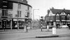
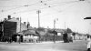
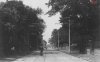
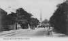
Question to you guys please, i live by the armarda pub once the erdington arms, well my question is where the erdington arms used to stand on the cross roads of gravelly hill & slade road where slade road bends round to go up slade road to the railway bridge, does anyone have any pictures of the view towards the bridge looking up slade road please?
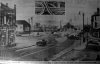
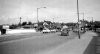
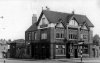
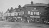
also where spaghetti is now stood to salford bridge where all those streets where bull dosed down roads like Leamingon road Bridge road woodley avenue Broadoakes road top part of copelly hill ect ect im really interested in seeing those old roads how the area used to look i mean especially leamington road to slade road area please!!!! i also gather that the road crew & workmen used to use Burlington house top of copelly hill as there tea room whilst building spaghetti junction? then they boxed it in by the motorway then pulled this fantastic building down CRIMINAL!!!!!!!!!!!
Also guys there was a road called Broadoaks road between Powick road & slade road?????????? if this is the case how could it of fitted between these 2 roads because at the backs of powick & slade road there is a gully way to garages! was this Broadoaks road a mistake on the map? maybe powick & Broadoaks road are the wrong way around!!!
i mean all this is in living memory right!! have any photos been taken by the Spaghetti work crew of the area before work started?????????? photos must of been taken right?? how can we get to see them???? there must be 1000's of photos of this area to be bull dosed down?????? who has them? birmingham city council???????????
i really want to see these photos,
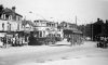
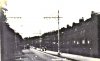
Here pre spaghetti with Broadoaks road??? between powick & slade road,,

many many thanks Ricco,,
Question to you guys please, i live by the armarda pub once the erdington arms, well my question is where the erdington arms used to stand on the cross roads of gravelly hill & slade road where slade road bends round to go up slade road to the railway bridge, does anyone have any pictures of the view towards the bridge looking up slade road please?
also where spaghetti is now stood to salford bridge where all those streets where bull dosed down roads like Leamingon road Bridge road woodley avenue Broadoakes road top part of copelly hill ect ect im really interested in seeing those old roads how the area used to look i mean especially leamington road to slade road area please!!!! i also gather that the road crew & workmen used to use Burlington house top of copelly hill as there tea room whilst building spaghetti junction? then they boxed it in by the motorway then pulled this fantastic building down CRIMINAL!!!!!!!!!!!
Also guys there was a road called Broadoaks road between Powick road & slade road?????????? if this is the case how could it of fitted between these 2 roads because at the backs of powick & slade road there is a gully way to garages! was this Broadoaks road a mistake on the map? maybe powick & Broadoaks road are the wrong way around!!!
i mean all this is in living memory right!! have any photos been taken by the Spaghetti work crew of the area before work started?????????? photos must of been taken right?? how can we get to see them???? there must be 1000's of photos of this area to be bull dosed down?????? who has them? birmingham city council???????????
i really want to see these photos,
Here pre spaghetti with Broadoaks road??? between powick & slade road,,
many many thanks Ricco,,