• Welcome to this forum . We are a worldwide group with a common interest in Birmingham and its history. While here, please follow a few simple rules. We ask that you respect other members, thank those who have helped you and please keep your contributions on-topic with the thread.

    We do hope you enjoy your visit. BHF Admin Team

Gosta Green Through Duddeston

Can someone help me out here. Do you know the location of this photo on Vauxhall Rd. I can't seem to place it, but I would hazard a guess that it was on the opposite side of the road to the dairy. But I would only be guessing. Sorry about the quality of the photo but it was spread across two pages.

Phil

NechellsVauxhallRd.jpg
 
Hi Phil you,ve got a great photo there it,s Mrs Dades shop on the corner of St James St and Vauxhall Rd. Dek
 
Dek

I must have passed by there many hundreds of times, but for some reason it has failed to register with me. Even now you have told me I still cant picture it. All I can remember down that end of Vauxhall Rd is the dairy, the park and maybe one or two shops toward Lawley St. It's amazing what the mind does as we get older.

Phil
 
Yes Phil our memories do us no favours it is so annoying when you can,t recall something this shop is etched into my brain we had a slate there and used the shop most days of the week. There were only two other shops on Vauxhall Rd one was by the old Lamp Pub the other was on the corner of Chickerley St that was an outdoor. Dek
 
Here is a cutting from 1972 when the last fodder business in the city left its old site in duke St
mike

Fodder_business__gosta_green_1972B.jpg
 
Not too good photographs, I will agree. Taken at the wrong time of day.
I shall post where they were taken tomorrow or the next day.
 
Ernie,

Let me have a guess before you put the names to them. The first one I am not too sure of, I thought it might be the end section of what was Ashted Row at first but I settled for the junction of Cromwell St & Rocky Lane. The next one is the top end of Heneage St near to Holt St. Next is Nechells Parkway or the section that used to be Great Lister St by Willis St and St Matthews Church. The last on is Great Lister St again at the junction of Proctor St the building on the corner is CSY Precision Engineering Co.

Phil
 
Lovely Photos
People were poorer then but I bet they were happier and not so lonely .
I remember living in one of those tiny terraces backing on to a courtyard . 72 Willis street . I dont remember the sleeping arrangements because I was tiny .
But I have this vague vision of me having to sleep with my nan . There was mum and dad , 3 kids and nan in 2 bedrooms . I suspect Julie and Sue slept in mum and dads room not very good really . We hadn't got toilets or a bathroom we had to go out to the courtyard where there were 3 loos . A brew house of course.
I sort of remember a brown sink in the kitchen and no cupboards only a high shelf where nan kept things . I suppose it was not that hi but to a 6 year old it was . It was all painted this dark and dinghy green . Mum then decide to get some stuff on the never never and got one of those tall narrow kitchen cupboards with the pull down shelf like think . was it called a Kitchenette . It was all the rage in the 50s . She got a table and 4 chairs to match .
Mum got a job to help pay for this and on her first day at work she came home and our Julie who was about 7 years old had got a razor blade and slashed all the seats of the chairs because she was upset at mum working . The furniture wasn't a week old ! That must have been awful for mum really trying to get some thing nice together .
I also remember playing down the bomb peck I think it was the bit of ground near St Mathews . We found a package all wrapped up . It was always exciting playing on the bomb sites because you never knew what you would find . We brought it home and started to unwrap it in the yard . It was a dead tortoise with maggots crawling through it . We were fascinated .
Mum grabbed us gave us a good hiding an put each one of us standing in the sink and scrubbed us down with a scrubbing brush and carbolic soap .
I am smiling now but I screamed the place down and thought she was cruel . But now as I have grown older I sit and laugh at that . Boy was she mad heh
Oh I love this site it brings back some memories
Jean x
 
Phil. Three out of four is very good, but I knew some would be easy.
Jean, That is a great write up, I loved reading that . Will catch you both later.
 
Not too good photographs, I will agree. Taken at the wrong time of day.
I shall post where they were taken tomorrow or the next day.


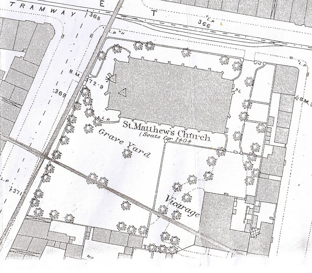
Nice pic with St Mathews in the distance. May be slightly off topic, and I dont want to hijack someone elses thread, but does anyone happen to know where the remains from the Graveyard were removed to, when, and whether the headstones were moved as well.

My G G Grandfather was buried there in the 1850s. I had a look a few years ago and there are only a few graves left, so presumaably it was a lot bigger till the dual carriagway was built. I also had a look at the old stones in the park behind the Ashted Hamlet p.h but its not there either.
 
Col i don,t ever remember St Mathews having much of a graveyard at all Gt Lister St ran along the side where the Dual Carriage is now at the the front was Willis St If at all it must have been behind the church Dek
 
col h,

I can't ever remember any exhumations at St Matthews whilst any of the roadworks were being carried out. Perhaps some of the gravestones have been removed for safety reasons. It was never a very big churchyard and I am not sure that it was ever encroached on.

But hey what do I know, you should try Aston Parish Church as the mother church I think they hold all the records.

Phil
 
Thanks,

Been looking for an old 19th century map on line, but had no luck. The few graves that I did find were round the back, but from memory, and it was a long time ago when I researched it, there were far too many graves for the size of the churchyard as it is now.
 
I could not say what happened to the graves, I agree with Phil that Nechells Expressway did not touch any part of Saint Matthews church or grounds. The boundary with Willis Street seems to be as it was in the 1940 -50's.
 
Thats an interesting map mike i remember the area to the right of the church being a playground in the 50s-60s. Dek
 
Ernie

So where was the first photo of, the trouble is it has probably changed again since then.

Phil
 
I could not say what happened to the graves, I agree with Phil that Nechells Expressway did not touch any part of Saint Matthews church or grounds. The boundary with Willis Street seems to be as it was in the 1940 -50's.

No, my mistake really. I'm dont remember the area prior to the 70s. and made the assumption based on how close the road is I suppose.

Heres a - not very good - map from the 1880s. Does look like the churchyard covered the whole area where there were houses and a Vicarage by 1913. but its not really detailed enough to be conclusive is it ?
 
Mike,

looking at your maps and today on google, I don't think the church or graveyard has been affected by any of the roadworks up to date. In fact St Matthews was always quite close to Great Lister St before the new road was cut through as these two photos show. The first one is in 1900 when the church still had its steeple you can see Great Lister St quite close behind the church. In the second one it looks as if they are just beginning to build the Parkway.

Phil

27/11/11. For some reason I no longer have the c1900 photo so I have substituted a later photo of Great Lister St that shows on the extreme left of the photo the outer edge of the church and its relation to the road.

NechellsGreatListerStNrTaylorSt2.jpg
NechellsAerialViewoverStMathews.jpg
 
Yes Phil the church wall ran adjacent to Gt Lister St there was only the pavement between the wall and the road if i remember right the wall ran all the way round the church perimeter. Dek
 
POST 1802 The first photograph is at the top end of Love Lane looking along ( the old Aston Road ) towards Gosta Green. Where my grandmother was born in 1873.
The second photograph was at the end of Heneage Street by the canal bridge looking across Holt Street up the hill towards Woodcock Street.
Many a walk to the swimming baths both from school and Sunday mornings for a swim and a cup of Horlicks afterwards.
The third photograph is the bus leaving Nechells Parkway and turning on to what was left of Great Lister Street. The clump of trees on the right would have
been about where Lister Terrace once stood. My Great Grandparents lived there in 1881.
The fourth photogaph is looking along Great Lister Street towards Dartmouth Street, The white building on the right used to be 243 and 244 Perks Wltr
( Walter ? ) corn merchants ( I can still see those sacks of seed and the dusty smell of them. ) A lot of people kept pigeons ,poultry ect so
these shops thrived years ago. The other shop was 166 Perkins William corn merchants at the corner of Scoffield Street.
Sorry I took so long as I got timed out yesterday so if you post then type it in Microsoft Word then Cut And Paste (SAVE ) onto the thread you may not get timed out and lose your text.
 
Phil. Looking at your 1816 post i wondered if Willis Street had changed after your pic 2 was taken.
I may take a look next time I am that way, but even then I may be left undecided.
 
Dek. Thanks, such a pity but that's progress once more. At least before I am gone there are still a few reminders that it was not all a dream.
 
Ernie

Yes I fear you would be wasting your time, you would not see much more than these two views from either end. At least you can see from these posts that the original wall is still in place. If somewhat a little smaller in height.

Phil

WillisSt.jpg
StMatthews.jpg
 
Phil. Thank you for posting the photographs, i have only viewed it as I pass on the dual carriageway and wonder if I would find my way around to view it from the other angle. Yes Phil, I would agree about the wall being a little smaller in height.
 
Went and had another look in the churchyard couple of days ago, of the older graves (mid 19th centery)only a few have legible headstones.
The wall doesnt look as old as the church to me though, if the size of the churchyard wasnt reduced when the dualcarriagway was built, I wonder if perhaps it was at some earlier time. Although it doesnt look like it.

Thanks for your help anyway.
 
Back
Top