-
Welcome to this forum . We are a worldwide group with a common interest in Birmingham and its history. While here, please follow a few simple rules. We ask that you respect other members, thank those who have helped you and please keep your contributions on-topic with the thread.
We do hope you enjoy your visit. BHF Admin Team
You are using an out of date browser. It may not display this or other websites correctly.
You should upgrade or use an alternative browser.
You should upgrade or use an alternative browser.
Fisher Street
- Thread starter MikeP
- Start date


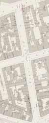
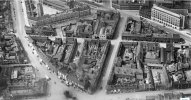
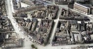
Hi mikejee, I don't know how you do it, but over the years you have been so helpful to me and come up with the goods. I have a family history project intended to try to identify exactly where my ancestors lived. In some cases, with the help of you and Britain by Air, I have been able to identify the houses where they lived. Thank you for this, I know I will be asking more.Below is a photo of the other end of Fisher Street to no 48. Also a map with wome numbering , including 48, and the pub shown in photo marked
View attachment 217145View attachment 217149
also mike not sure if you know this useful map..just move the blue dot to the left map will fade out to show you what is there now..you can move the map around and put in various st names..click on link below i have set the map on fisher st..long gone now..lyn
Hi Astoness, You too have also provided me with invaluable information over the years which is really appreciated. All of my maternal side came from Birmingham and surrounding areas. I do have and use the Georeferenced Maps viewer - Map images - National Library of Scotland and reference it a lot, but the older maps (as far as I can see) don't include house numbers. Fisher Street is somewhere under Aston University along with Colesehill Street, Does Street, Princes Street and many others where my ancestors used to live. It is sad that it was all destroyed in the 1960's
yes mike as my slide map shows it used to be where the uni is now...i have spent many hours having fun with this mapHi Astoness, You too have also provided me with invaluable information over the years which is really appreciated. All of my maternal side came from Birmingham and surrounding areas. I do have and use the Georeferenced Maps viewer - Map images - National Library of Scotland and reference it a lot, but the older maps (as far as I can see) don't include house numbers. Fisher Street is somewhere under Aston University along with Colesehill Street, Does Street, Princes Street and many others where my ancestors used to live. It is sad that it was all destroyed in the 1960's
") should you need any help with researching your family just start a new thread under our surname interests section of the forum
should you need any help with researching your family just start a new thread under our surname interests section of the forumlyn
Below is a photo of the other end of Fisher Street to no 48. Also a map with wome numbering , including 48, and the pub shown in photo marked
View attachment 217145View attachment 217149
Hi Mikejee
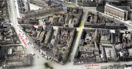
Thank you for providing the house numbers for Fisher Street, it has been really helpful to me. Following on from that I found a photo, courtesy of 'Briton from Above' of Fisher Street and surrounding area taken in 1937. I took your map and turned it around to align with the photo.
I enhanced the photo and colourised it to make it clearer. Others may be interested in it and may be able to add to it or correct me if there is something wrong.
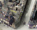
I was able to identify the house (Number 48) where my G. G. Grandparents lived Thomas Bramley (Bromley) and Sarah Bramley nee Carr according to the 1891 census. I have also attached a thumbnail close up of their house.
I hope the images help others interested in the area, if anyone has any more street photos of the area I would love to see them
If there is anyone else related to Bramley/Bromley (there ares spelling differences in the census records) I would love to hear from them
Lastly, I can post the unaltered B/W image if anyone was interested.
Regards
Mike
Attachments
Thank you . That is interesting. I assume the enhancment was done by AI. If so then do remember that the program sometimes (as with the Aston Villa game against West Brom that never happpened) adds things it thinks fit. On another forum today, an aquaintance told how he has asked AI to enhance a rather blurred photo. His comment is copied below:
I have found AI totally hopeless. It needs another decade to get itself sorted. However I have a slightly out of focus photo of a group taken in 1952, so thought AI might be able to focus it. It focused it well but found something wrong with the photo, which it corrected by showing anyone with their head down holding a mobile phone...in 1952!!!
Top
Totally agree with you, I use various software including Photoshop. The enhancements I use include de-speckle and sharpen but the colourising in this case was through MyHeritage which I assume uses AI.Thank you . That is interesting. I assume the enhancment was done by AI. If so then do remember that the program sometimes (as with the Aston Villa game against West Brom that never happpened) adds things it thinks fit. On another forum today, an aquaintance told how he has asked AI to enhance a rather blurred photo. His comment is copied below:
I have found AI totally hopeless. It needs another decade to get itself sorted. However I have a slightly out of focus photo of a group taken in 1952, so thought AI might be able to focus it. It focused it well but found something wrong with the photo, which it corrected by showing anyone with their head down holding a mobile phone...in 1952!!!
Top
It is all part of a family history project I am working on, not all census records have house numbers, but where they do I try to see if I can find the number on a map (you have helped me no end of times in this) then see if I can find a photo and identify the house from there.
It is not everyone's cup of tea to colourise photos but for me it has proved invaluable and brings some images to life. We often think that the world was in black and white in days gone by, the photos can be cold and dreary but in reality the world was in colour.
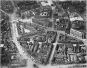
For completeness, attached are the original B/W photo I captured, and enhance one of the section I was interested in and a colourised version without text. Someone may be interested.
Regards
Mike
Attachments
Mark Tooze
master brummie
AI Enhancement looks brilliant!!!
mike 'the stove'
New Member
I am researching Fisher Street as well.! Trying to get information on the Fisher Street works 42-44 Fisher Street They were occupied by Clement West and his wife Sarah Anne West manufacturing hardware. My interest is in Hurricane lamps a patent was issued to Clement in 1920.
The Wests appear to have been in Fisher Street from around 1888 until the mid 1920's when the premises were taken over by AW Sanderson also lamp manufacturers.
Can anyone help with pictures of the works what was actually made there advertisements and which year Sandersons took over?
Maybe old newspapers would have an article on the takeover?
Last edited:
mike 'the stove'
New Member
Can anyone who is knowledgeable about Birmingham or has access to documents help with my question about Fisher Street?I am researching Fisher Street as well.! Trying to get information on the Fisher Street works 42-44 Fisher Street They were occupied by Clement West and his wife Sarah Anne West manufacturing hardware. My interest is in Hurricane lamps a patent was issued to Clement in 1920.
The Wests appear to have been in Fisher Street from around 1888 until the mid 1920's when the premises were taken over by AW Sanderson also lamp manufacturers.
Can anyone help with pictures of the works what was actually made there advertisements and which year Sandersons took over?
Maybe old newspapers would have an article on the takeover?
hi mike very good chance that the takeover would have been reported...are you subscribed to the british newspaper archives its not that expensive i think its £14.99 for a months subs and can prove invaluable when researching.. the link is belowI am researching Fisher Street as well.! Trying to get information on the Fisher Street works 42-44 Fisher Street They were occupied by Clement West and his wife Sarah Anne West manufacturing hardware. My interest is in Hurricane lamps a patent was issued to Clement in 1920.
The Wests appear to have been in Fisher Street from around 1888 until the mid 1920's when the premises were taken over by AW Sanderson also lamp manufacturers.
Can anyone help with pictures of the works what was actually made there advertisements and which year Sandersons took over?
Maybe old newspapers would have an article on the takeover?
lyn
Home | Search the archive | British Newspaper Archive
Whether you are a researcher, historian or you simply want to know more about Britain's history, take this fantastic opportunity to search The British Newspaper Archive - a vast treasure trove of historical newspapers from your own home.

Pedrocut
Master Barmmie
I am researching Fisher Street as well.! Trying to get information on the Fisher Street works 42-44 Fisher Street They were occupied by Clement West and his wife Sarah Anne West manufacturing hardware. My interest is in Hurricane lamps a patent was issued to Clement in 1920.
The Wests appear to have been in Fisher Street from around 1888 until the mid 1920's when the premises were taken over by AW Sanderson also lamp manufacturers.
Can anyone help with pictures of the works what was actually made there advertisements and which year Sandersons took over?
Maybe old newspapers would have an article on the takeover?
I don’t think Sarah Anne West was ever at Fisher Street. In 1891 she was in Handsworth and in 1901 in Erdington.
It was her son Clement and his wife Emma.
mike 'the stove'
New Member
Thanks Lyn I have considered the Newspaper subscription but at £15.00 per month for the little I would use it comes very expensive..!
My interest in hurricane lamps is a hobby which keeps my brain alert, tracking down who made what and where is sometimes like a murder mystery, searching for clues .!
My interest in hurricane lamps is a hobby which keeps my brain alert, tracking down who made what and where is sometimes like a murder mystery, searching for clues .!
mike just to point out that you do not have to continue with monthly subs...as soon as subscribe you just cancel any further subs...having said that as just a hobby i take your point...on the other hand if you are researching your family and any dark secretsThanks Lyn I have considered the Newspaper subscription but at £15.00 per month for the little I would use it comes very expensive..!
My interest in hurricane lamps is a hobby which keeps my brain alert, tracking down who made what and where is sometimes like a murder mystery, searching for clues .!
 they may have had its a great source as i have found out
lyn