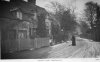
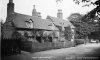
There are many postcards of Church Lane in Handsworth. Below are five pcs of the old cottages on Church Lane. Although they're very picturesque and very photogenic, I wondered if there's another reason why they were photographed so often. There's a sign in a couple of the photos to the left of the cottages, but I can't read the writing. I wonder if that has anything to do with its popularity. Maybe it was a tearoom? Or maybe someone famous stayed there? Perhaps it was a particular attraction for ramblers exploring Handsworth ? Viv.
-
Welcome to this forum . We are a worldwide group with a common interest in Birmingham and its history. While here, please follow a few simple rules. We ask that you respect other members, thank those who have helped you and please keep your contributions on-topic with the thread.
We do hope you enjoy your visit. BHF Admin Team
You are using an out of date browser. It may not display this or other websites correctly.
You should upgrade or use an alternative browser.
You should upgrade or use an alternative browser.
Church Lane Handsworth
- Thread starter Vivienne14
- Start date
A Sparks
master brummie
Gosh I can't imagine whereabouts that would be in Church Lane!
I was wondering if the area where the trees are might be where the school was built as the road bends round like that?
Very difficult to tell as the road looks far more narrow then.
I tried with a magnifying glass but I can't make out the sign either.
Great photos though.
I was wondering if the area where the trees are might be where the school was built as the road bends round like that?
Very difficult to tell as the road looks far more narrow then.
I tried with a magnifying glass but I can't make out the sign either.
Great photos though.
pjmburns
master brummie
I don't know the area well enough to comment but there is a suggestion about the site of these cottages here https://www.search.birminghamimages.org.uk/Details.aspx?&ResourceID=770&SearchType=2&ThemeID=176
Janice
Janice
Very helpful Janice. Looking at present day Google maps there seems to be a slip road (above my blue line) near the College Road/Grove Lane end of Church Lane. I wonder if this was around the site of cottages - the old photos show a sharp bend, so they might well have been somewhere at this point. There's now a row of 1930s houses along there. College Road has obviously been widened considerably/made into the A4040. Maybe the road was widened in the 1930s when the houses were built? Viv.


AS was said in the reference they were demolished after the 1938 map. It is before th 1960 map also (which, bacause the years are publication dates) probably means between about 1935 and 1957, Looking at the c 1890 map I think they can only be the buildings in red, which are one of the few sets of similar buildings and also have two smaller next to another larger oneon the right slightly set back from the other two.
Attachments
So that's on the other side of the road Mike. Looks very like it with the curve in the road on your old map. The road's been radically changed over time. It's much, much wider in several places and the houses now seem to be set further back from the road. Would be interesting to see how the road has changed in relation to the earlier Church Lane.
The other question in my mind is which church does Church Lane relate to? Was it St Mary's with its memorials to Boulton and Watt? It also has some very ancient features. If so, were the cottages cashing in on the visitors to the Church - hence the sign on the cottages? Maybe refreshments? Viv.
The other question in my mind is which church does Church Lane relate to? Was it St Mary's with its memorials to Boulton and Watt? It also has some very ancient features. If so, were the cottages cashing in on the visitors to the Church - hence the sign on the cottages? Maybe refreshments? Viv.
To check the assumption that the cottages in red are the ones, I did an overlay. This makes them just straggling where Wineleigh road joins. In case it is of interest they are below
Attachments
Very helpful Mike. Theres a retaining wall along there by the traffic lights which, I think is the same wall. The cottages would have lined up with that wall. So the modern house in view (1980s ?) was built a little further back from the original lane. The road was been widened and straightened along the opposite side travelling in the direction Hamstead Road. It certainly points to the demolition of the cottages to make way for the wider road. Winleigh Road itself looks like a 1970s/80s road so it wouldn't have been constructed until some 40years after the demolition of the cottages.Viv.

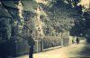
Two more of photos of Church Lane in Handsworth. Think there's a milkman (carrying a milk churn?) in the middle of the road in the second one. Interesting to see that some parts of Church Lane had rows of trees separating the footpath/pavement from the lane. Viv.


pjmburns
master brummie
In Kelly's for 1892 and 1900 the list includes Sunny Bank, The Fieldhouse (both on Mike's map) then The Oaklands and then a market gardener William Smallwood. I think the Smallwoods (can't check as the Handsworth site seems to be down at the moment) are listed as owning the cottages at one time so could the sign be to do with that business?
Janice
Janice
Church Lane Handsworth - probably early 1900s. Very quiet scene. Why did people still walk in the middle of the road when there were pavements?/footpaths ? I suppose there weren't so many hazards. Viv.

Radiorails
master brummie
It is curious why people walked in the road - and still do as far as I see - when there was a pavement especially considering the road hazards, where no self respecting person would fear to tread, ")
I wonder if it is/was because so many folks who lived on the perimeter areas of cities and large towns were used to walking rural roads which did not have pavements.
I wonder if it is/was because so many folks who lived on the perimeter areas of cities and large towns were used to walking rural roads which did not have pavements.
S
Stitcher
Guest

Another one that shows peace and tranquillity without the motor vehicles.
A 1937 Church Lane view with, what I think is, a pub on the right. Anyone know ? The photographer seems to have excluded it from the views in post #1. Viv.


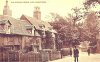
These cottages, photographed in 1955, were opposite Lea Bridge House. Handsworth. The Lane was originally called Field Lane, a bridle path leading to St Mary's Church. These look to me like labourers cottages. Image and info from Birmingham Images.
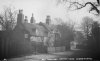
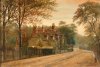
 And this was Lea Bridge House on Church Lane (just inside Handsworth Park grounds) in 1956.
Some details of this Georgian house which no longer exists.
Occupants:
1894 John and Elizabeth Smith (daughter of Richard Poole of Tillington, Stafford)
1906 Frank Hughes
1916 Jack Wasdell, son of Mr and Mrs E C Wasdell of Church Lane, was killed in action 1/7/1916
1931 Charles Wasdell, mudguard and cycle accessories manufacturer
1944 Edwin James Wasdell
Source: British Newspaper Archive


Last edited:
It had several outhouses and greenhouses and its own bowling green and pavillion. A heated garage must have been unusual, even in the 1950s. Wondering if this house had another name in the past.
Is there a map please showing this house ? Thanks.
Is there a map please showing this house ? Thanks.
Last edited:
unusual house to have inside handsworth park...i wonder if there is a map actually showing its location within the parkView attachment 219261And this was Lea Bridge House on Church Lane (just inside Handsworth Park grounds) in 1956.
Some details of this Georgian house which no longer exists.
Occupants:
1894 John and Elizabeth Smith (daughter of Richard Poole of Tillington, Stafford)
1906 Frank Hughes
1916 Jack Wasdell, son of Mr and Mrs E C Wasdell of Church Lane, was killed in action 1/7/1916
1931 Charles Wasdell, mudguard and cycle accessories manufacturer
1944 Edwin James Wasdell
Source: British Newspaper Archive View attachment 219263
View attachment 219265
lyn


Misleading caption Lyn from the library archives. This was the caption:

Thanks, Janice. There seems to have been a number of genteel houses along Church Lane (Field Lane), including Field House (named on map in post #23), home of George Henry Griffith, "father of the jewellery trade". Another was Carlton Cottage, home of Henry Charlton. Hardly what you'd call the usual impression of "a cottage" judging by the sale listing of household effects.


Source: British Newspaper Archive
Thanks, Janice. There seems to have been a number of genteel houses along Church Lane (Field Lane), including Field House (named on map in post #23), home of George Henry Griffith, "father of the jewellery trade". Another was Carlton Cottage, home of Henry Charlton. Hardly what you'd call the usual impression of "a cottage" judging by the sale listing of household effects.
Source: British Newspaper Archive
Last edited:
Field House was a school during the 1920s. Lovely setting for the school.

Source: British Newspaper Archive
Source: British Newspaper Archive
no worries viv we get lots of misleading captions...shame the house has gone though..thanks for the maps janMisleading caption Lyn from the library archives. This was the caption:
View attachment 219271
Thanks, Janice. There seems to have been a number of genteel houses along Church Lane (Field Lane), including Field House (named on map in post #23), home of George Henry Griffith, "father of the jewellery trade". Another was Carlton Cottage, home of Henry Charlton. Hardly what you'd call the usual impression of "a cottage" judging by the sale listing of household effects.
View attachment 219273
View attachment 219275
Source: British Newspaper Archive
lyn
We certainly do Lyn !
Another substantial house marked on the map (post #23) and having a Church Lane address is "Oaklands", it had four acres of land.
There's also a house named "Seabridge House" on Church Lane, near St Mary's Church, once occupied by Richard Southall jnr. It existed from at least 1819.


Source: British Newspaper Archive
There's also a house named "Seabridge House" on Church Lane, near St Mary's Church, once occupied by Richard Southall jnr. It existed from at least 1819.
Source: British Newspaper Archive