-
Welcome to this forum . We are a worldwide group with a common interest in Birmingham and its history. While here, please follow a few simple rules. We ask that you respect other members, thank those who have helped you and please keep your contributions on-topic with the thread.
We do hope you enjoy your visit. BHF Admin Team
You are using an out of date browser. It may not display this or other websites correctly.
You should upgrade or use an alternative browser.
You should upgrade or use an alternative browser.
Cheston Street Aston
- Thread starter Astoness
- Start date
fatfingers
master brummie
Never heard of Cheston St. Do you mean Cheston Rd ?
The building looks familiar, did it used to be Cressalls ?
The building looks familiar, did it used to be Cressalls ?
Frothblower
Lubrication In Moderation
just looked at my map and there is a chester st off rocky lane...
lyn
But yours is Cheston street Lyn
Frothblower
Lubrication In Moderation
oops...so it is froth...a kellys look up for aston paper mill will say if its chester st then..caption could be wrong..
froth..did you see the pic of the ressa pub i posted....
No, but I'll have a butchers
Lyn here's a Kelly's entry (got it from https://www.astonbrook-through-astonmanor.co.uk/inshawgen)
Kellys 1892
Inshaw John and sons paper makers Cheston Road Aston.
Viv.
Kellys 1892
Inshaw John and sons paper makers Cheston Road Aston.
Viv.
hi lynn
there is cheston road and chester street was off rocky lane chester street was the paper mills and the old M.E.B was on the corner of chester street
and then there was box magnetics next door the paper mills was up chester street on the opersite side of the rd just
passing the avenue rd and between white house street and cheston rd was a little 200 yards down rocky lane next rd to tubes foundrys which also went into cheston rd and down there was the post office sorting office of aston my uncle was the post master general there for years until he died
go down there it took you to thimble mill lane best wishes astonian ; alan
sylviasayers
master brummie
Just to confirm what has already been posted, Chester Street ran from 225 Dartmouth Street to Rocky Lane, and Cheston Road ran Rocky Lane to Thimble Mill Lane.
S
Stitcher
Guest
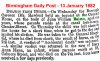
 1926.
1926.An aerial shot of Cheston Road, Aston.

Thats Chester street,and the old M.E.B building going down to,and around the corner of Rocky Lane
thanks for confirming joe
lyn
sospiri
GONE BUT NOT FORGOTTEN
Whilst this topic is current, one of my ancestors, John BAIZON (1817-1895), was lock-keeper at the Lock House, which on one census says it is "Cheston Street" but I assumed it was actually Chester Street. Am I right is assuming it was Chester Street and does the Lock House by any remote chance still exist? I presume there is/was a canal in the vicinity of Chester Street - not familiar with that area at all.
Maurice
Maurice
Phil
Gone, but not forgotten.
Maurice
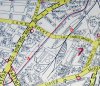
As the majority of the locks on that stretch of the Fazeley & Birmingham Canal are adjacent to Chester Street and the map shows two canal cottages (see attachment) and as Cheston Road does not show any cottages I think we might assume that it might be Chester Street you are looking for. Alas the whole area is today covered by industrial buildings and vacant sites
As the majority of the locks on that stretch of the Fazeley & Birmingham Canal are adjacent to Chester Street and the map shows two canal cottages (see attachment) and as Cheston Road does not show any cottages I think we might assume that it might be Chester Street you are looking for. Alas the whole area is today covered by industrial buildings and vacant sites
Attachments
sospiri
GONE BUT NOT FORGOTTEN
Thanks for the map, Phil, so the cottages are located in the midst of wood turning mills. That might enable me to pinpoint it a little more accurately in the absence of house numbers. Must have a dig in the trade directories. Thanks also to Lyn. No idea of the origin of his surname, but he was born in Basingstoke, perhaps there's some sort of link there.
Maurice
Maurice
Maurice.
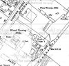
I assume you are talking about the 1881 census. If you look at the original , especially the surrounding houses, it certainly is Chester St.
Following the path of the enumerator he comes down Hubert St to the Corner (1 on the map below). He then goes to one lock-keepers house, then to John Blaize, then to a house attached to the sawmill (4) , then to a house attached to the glassworks (5) and then to house on Chester St Wharf, which must be the Corporation wharf with weighing machine (Weighing machine marked WM, but not clear at magnification here) (6), then he does to houses marked 1-15, where no 9 has a big court containing 9 backhouses, which must be the court marked 7 on the map. Unfortunately, the numbering changes shortly after and Kellys does not show numbers under old system, but this is the only possibility.
Therefore the two lock keepers cottages were enumerated between 1 & 4. Assuming they are marked on the map, then it a seems they are probably either the two buildings at X , which do not look like lock-keepers cottages, or, more likely the two at Y
The locks was at the top end of chester street running behind all tnose industreal premise
And what little of Darthmouth street coming from aston road north and the one time midlands counties dairy
Junction coming up Aston road north heading towards the city passing white house street andpalmers ware house
You would bend to the right hand rd wich was the beging of Darthmouth street
Heading along you would eventual come to the bridge where the cannal runs under the road
If you looked to your Left over looking the canal you would see those locks
And i beleive these locks are still there but no lock keepers house
At the same time you are looking down at the canal you could have seen most of chester street
Well at least white house street in the distance
And thinking of chester streeet and white house street there was the Avenue at his house with car head lamps
And spare bits in apple boxes for 2/6d and in Darhmouth street and about five hundred yards from that bridge
That over looks chester street and there was a big high glass block of offices
Over looking the cannaal
maurice im not great at this but if you look at phils map marking out the cottages no 1 and 2 and then look at this site which i think is brilliant...to the left of of the glass works and towards you a bit i think show the 2 cottages...if you slide the blue dot the old map will dissapear and whats there now takes its place...as you can see there is no sign of the cottages...think ive got that right lol i have spent hours going round brum on this site which i would imagine you already know of
https://maps.nls.uk/geo/explore/#zoom=18&lat=52.4943&lon=-1.8837&layers=176&b=6
https://maps.nls.uk/geo/explore/#zoom=18&lat=52.4943&lon=-1.8837&layers=176&b=6
terryb18
Gone but not forgotten R.I.P.
At the end of 1961 I left school and started work at Cressall Manufacturing in Cheston Rd. I was there all through 1962 and halfway through 1963 when I left to go and work at Bulpitts. I remember at the back of the premises there was a canal where we just had enough room to play football in our dinner hour. Also this was about the time of the big freeze in 1962/63 I think. If you was so inclined you could play football on the iced up canal, I think one or two of the lads had a game, but I can't remember me doing it, but I may have done.
sospiri
GONE BUT NOT FORGOTTEN
Phil, Alan, & Lyn,
If I ever fancy doing a bank job, I would employ you three to reconnoitre the place first! An excellent piece of detective work. You all seem to agree on the position of the Lock Houses, but sadly they are no longer there. A couple of years ago I had a mooch around that area with Google View and found nothing, but it is not an area I have ever visited. Now I can at least pinpoint the spot where they stood.
Not a close relative of mine - John BAIZON's daughter Mary Ann was married to my late wife's great grandfather - but canals have always fascinated me, though I don't like deep water! John had spent his life on canal boats & lockkeeping, but here is how another of his children met his sad end. Once again, many thanks for your help as always.
Maurice