-
Welcome to this forum . We are a worldwide group with a common interest in Birmingham and its history. While here, please follow a few simple rules. We ask that you respect other members, thank those who have helped you and please keep your contributions on-topic with the thread.
We do hope you enjoy your visit. BHF Admin Team
You are using an out of date browser. It may not display this or other websites correctly.
You should upgrade or use an alternative browser.
You should upgrade or use an alternative browser.
Cemetery - nearest to Deritend
- Thread starter wcadby
- Start date
I Can Only Think Of The Possibabilty,And What Comes To My Mine
Would And May be Ash Rd Saltley And Poss ; Key Hill , Ickneild St . But Saying That
I Think There Was Some Sort Of Grave Yard Around The Top End Of Bordesley St
But Saying That I Think This One Is For Wendy To Resolve , She,s The Expert ,
Have A Nice Day , Best Wishes ASTONIAN ,
Would And May be Ash Rd Saltley And Poss ; Key Hill , Ickneild St . But Saying That
I Think There Was Some Sort Of Grave Yard Around The Top End Of Bordesley St
But Saying That I Think This One Is For Wendy To Resolve , She,s The Expert ,
Have A Nice Day , Best Wishes ASTONIAN ,
W
Wendy
Guest
wcadby, If you click on main sites above then go to the Birmingham site on the left hand side there is a list click on burial grounds you can narrow it down by looking at when grounds closed. It could be Warstone Lane, Key Hill or Witton.

I am closing this thread for tidying up. The original request was for information about a cemetery in Deritend.
Edit done. Title made more specific and posts about the Police Station are now on a dedicated thread link below
https://birminghamhistory.co.uk/forum/threads/deritend-digbeth-police-station.59759
Edit done. Title made more specific and posts about the Police Station are now on a dedicated thread link below
https://birminghamhistory.co.uk/forum/threads/deritend-digbeth-police-station.59759
Last edited:
Lady Penelope
master brummie
Hi Viv, I know this is an old thread but I though I'd add my four pennorth. I do know that there was a burial ground opened in 'Cooper's Field' which I believe was near the old windmill owned by Mr Cooper. I think St Martin's was becoming overcrowded even around the late 1700's as grave was piled upon grave, before Park Street was built. I just wondered if anyone else had information on this ground?
Always in favour of reviving old threads Pen. Thanks.
Going on your info, I wonder if this was it ? A burial ground not actually on Deritend, but near to Cooper's Mill House (also known as Heath Mill). It proposes a plan for a Chapel and burial ground and claims it will partly form a beautiful hamlet, dated 1788

Source : Birmingham Newspaper Archive
Going on your info, I wonder if this was it ? A burial ground not actually on Deritend, but near to Cooper's Mill House (also known as Heath Mill). It proposes a plan for a Chapel and burial ground and claims it will partly form a beautiful hamlet, dated 1788
Source : Birmingham Newspaper Archive
Last edited:
Lady Penelope
master brummie
Thanks Viv, It sounds very much as if this is the one. I was tracing one of my 'lines' and came across it some years ago but everything is packed up in boxes in the garage and I keep saying I'll go through them. One Day!
I've lots of those 'One day' tasks too Pen !
I've seen a map with the Chapel marked. Be interesting to see if it has an associated burial ground.
However I can't remember what map it was. Maybe Mike could help, please ?
I've seen a map with the Chapel marked. Be interesting to see if it has an associated burial ground.
However I can't remember what map it was. Maybe Mike could help, please ?
Last edited:

Lady Penelope
master brummie
No sign of the chapel or the 'pleasant little hamlet' mentioned in Viv's cutting. It couldn't have been very salubrious being next to the tannery could it?
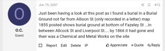
According to these two posts the burial ground opened in 1791 and closed in 1855. Only 46 burials, records were at St John's Church, now probably with the Library of Birmingham.
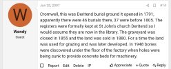
Remains were found beneath the factory later built over the ground.
Remains were found beneath the factory later built over the ground.
Attachments
Have added the above to the Disnternment/Reinternment thread for future reference. Hopefully, the remains were eventually removed from the site in later redevelopment, so at least it's been flagged up on that thread.
Last edited:

So, today, the burial ground must have been approximately by the red marker - alongside Liverpool Street.

Last edited:
It was listed as St John's burial ground, Liverpool Street, Deritend in 1873. In another discussion of the Burial Board Department of the Home Office, the burial ground was reported as one of several Birmingham grounds that had practically discontinued burials.

Source: British Newspaper Archive
Source: British Newspaper Archive
Last edited:
Lady Penelope
master brummie
On the map Mike posted on #15 it looks as though there were some substantial grave stones.
I've been trying to remember the details of the burial I was interested in. It was Eleanor Lowe (can't remember her d.o.d but I thought it was earlier than that mentioned above). I'm trying to connect her to the Lowes of Ravenhurst as I can't think why she should be in that area unless there's a connection. Her daughter married one of the Geast family of Great Barr who were relatives of the Geast's who's address was Deritend Bridge. There was definitely a connection to Mr Cooper too but can't find what it was either. Too many brick walls which need re-visiting.
I've been trying to remember the details of the burial I was interested in. It was Eleanor Lowe (can't remember her d.o.d but I thought it was earlier than that mentioned above). I'm trying to connect her to the Lowes of Ravenhurst as I can't think why she should be in that area unless there's a connection. Her daughter married one of the Geast family of Great Barr who were relatives of the Geast's who's address was Deritend Bridge. There was definitely a connection to Mr Cooper too but can't find what it was either. Too many brick walls which need re-visiting.
Lady Penelope
master brummie
Viv, I wonder if the little patch of grass in your screen shot might be the remains of the burial ground?
Looks like a serious possibly Pen ! Thanks.
A Streetview of the land. I think the building in the background must be partially covering the earlier burial ground.

A Streetview of the land. I think the building in the background must be partially covering the earlier burial ground.
Last edited: