Hi cheeky71 I have many happy memories of Carrington road as in the 1950s it was part of the route we used as kids to race against each other how it worked was we met in the middle of Arthur Street where we all lived your competitor would run left along Arthur St down Dixon Rd along Carrington Rd and back up Bordesley Park Rd to the starting point in Arthur St and the other guy would run it in reverse and the first one back would be the winner it did not cost anything but pretty heavy on your lungs. Regards Acklam19.
That sounds like me with me on the new estate playing “tracking” in the late 1970s until the mid 80s with my friends on the estate, the new estate has loads of alleyways that you could run down, before the A45 extension was build from the railway bridge next to Bolton Road there was a bomb peck which I assume was the old houses from Butler Street South next to the scrap yard (which was there until 1982/3) then it was flattened for regeneration and big huge pipes were put on there for the A45 redevelopment in 1983/4, we played on them too, nothing was out of bounds.
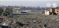
It was the same for Carrington Road, when we moved in 1973 Carrington Road was a bomb peck at the side of Dixon Road School there were these massive humps of rubble bricks and old furniture, it stayed like that until the late 70s when it was eventually levelled out grassed over and became kind of hill and a short cut from Sandfields Avenue up to Dixon Road, I used it when I was at Regents Park School and Dixon Road School nothing was built on the old Carrington Road site from Dixon Road downwards to Sandfields Avenue until about 1998/99 when new houses were built from the bottom of Cooksey Road up into Sandfields Avenue. At the top by Dixon Road where Carrington Road started is now a car park and football field for Regent Park School all built only in the last 30 years.
At the bottom of Cooksey Road where it kind of Bolton Road but in the Dixon Road School Play ground there was a building like an old air raid shelter it had thick roof made of concrete and stone with two entrances bricked up I remember sitting up on there in the summer with my mates with my Radio on listening to the Top 40 we also played rounders and cricket at Dixon Road School until the early 80s, when the council decided they wanted put up a 6ft wire fence from the end of Cooksey Road all the way up into Sandfields Avenue stopping us from playing in these areas, deemed unsafe, the top by Dixon Road was also fenced off too so stopped any short cuts down the hill, the miserable council had nothing better else to do that day, but someone very naughty I’m not naming names here cut a hole in the fence so we kept playing on there no one ever told us to get off, it eventually was got re-fenced by 1986.
Dixon Road closed down completely in 1979 and was left empty for two years when it became The Newlands Centre in early 1982 it stayed as an educational unit for Children that kept wagging and skipping school (Central TV filmed a drama/documentary programme there in the summer of 1982 it was shown on ITV in the summer of 1983 I can remember them filming it on Dixon Road and Cooksey Road all the big lights and cabling for the cameras) but for the life of me I don’t remember the title of the programme I was about 12 at the time.
all these familiar place have long gone now as there are houses that back on to the lower part of Dixon Road School where the fencing was the bottom part of Dixon Road School was converted into flats in the mid 90s but they have also gone now, but I think they have been bought out for redevelopment again into some kind of residential flats, but the last time I looked the big windows were boarded up, the top part of Dixon Road School is now a school for girls, and before it became the girls school it was a second hand furniture shop, i went in to have a look round, and memories came flooding back, the hall still had the painted lines on the floor for PE etc the big strip lights hanging of the chain supports, we had our Silver Jubilee 1977 party in that hall, I was only 6 but I still remember it, all the bunting up all over the estate in the school!
There was so much to explore growing up during that time, as we still had part of the old and new estate, I remember the old derelict houses on Bolton Road just past Small Heath bridge, some were still there and on the top half of Cooksey Road, there were still old houses at the back of the Kingston Bingo Hall by St Andrews Road, Emline Street, Sara Road, Carrison Lane, these house were still standing well into the mid 80s, just empty and derelict, there was also Turners on Regents Park Road which was left empty for a few years and not demolished until 1982/3 along with the Oxford Pub next to it on Coventry Road all these were left empty for what seemed like years, loads of old buildings to explore which for a youngster was a prime adventure exploring these old building I saw no danger in looking in these old houses, with rotting floor boards rickety stairs didn’t give it a thought it could collapse at any time but some your old houses great me and my friends great memories.
All that has sadly gone with time, but listening to your all your fond memories from the 1950s was great to hear I wish I could go back in time to see the youngsters of Carrington Road both Butler Streets, Bordesley Park Road from that post war era making up their own fun, I bet it was such a great time with no cares in the world, even in my era we didn’t have a lot none of us had personal computers or mobile phones back then, I had a bike when I was 12 and that was huge but we still had to make up our own fun, and we did, as we had to we had no choice and I’m talking about the early to mid 80s here…him I did have an orange space hopper in 1978 but I hope that doesn’t count!
Sorry for the long rambling post but I do like and find your memories of the area before the redevelopment of the area fascinating, thank you for sharing.